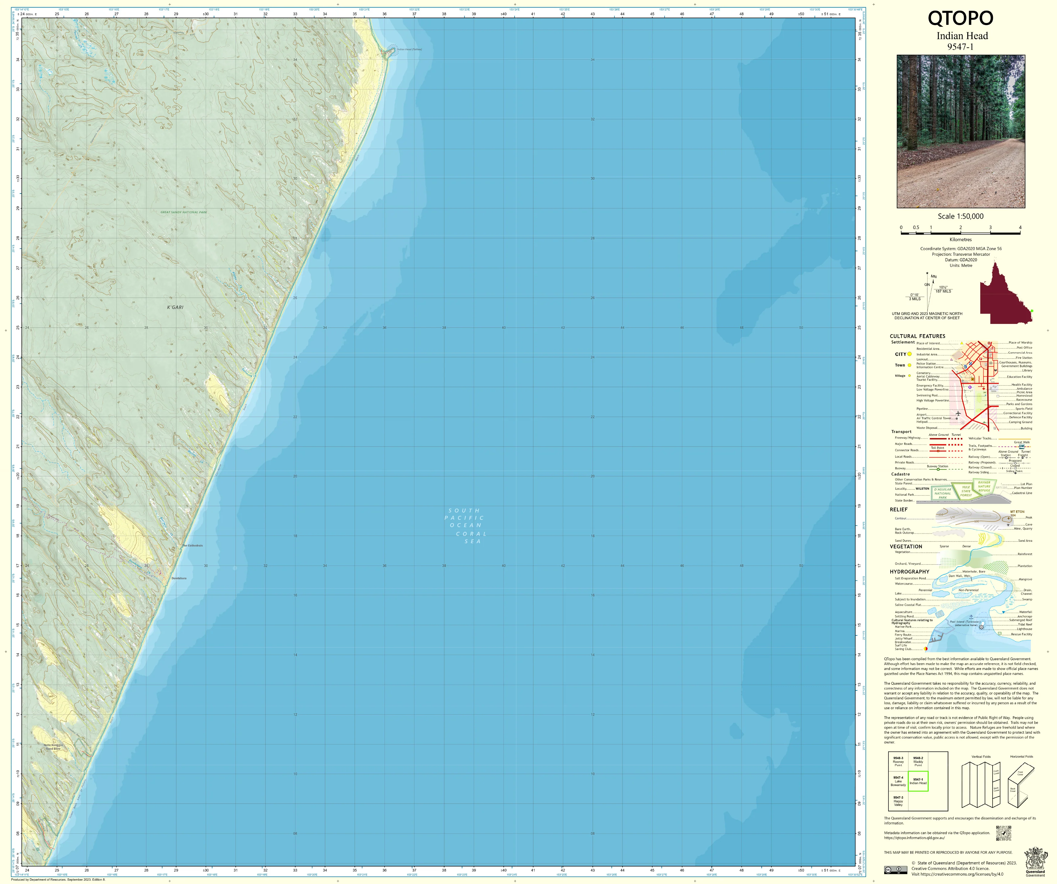
9547-1 Indian Head QTopo 1:50,000 Topographic Map
QTopo 9547-1 — Indian Head
1:50,000 Topographic Map
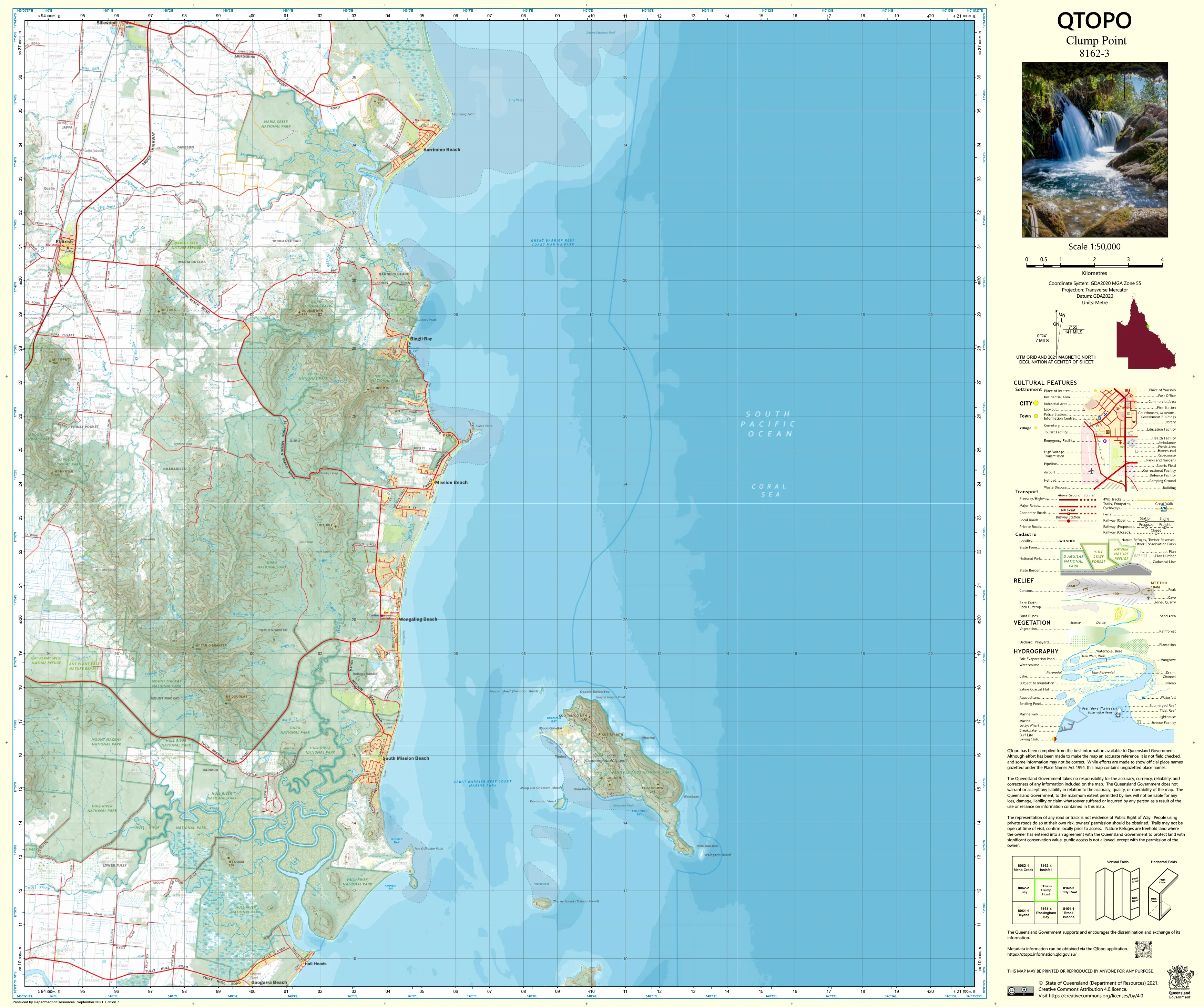
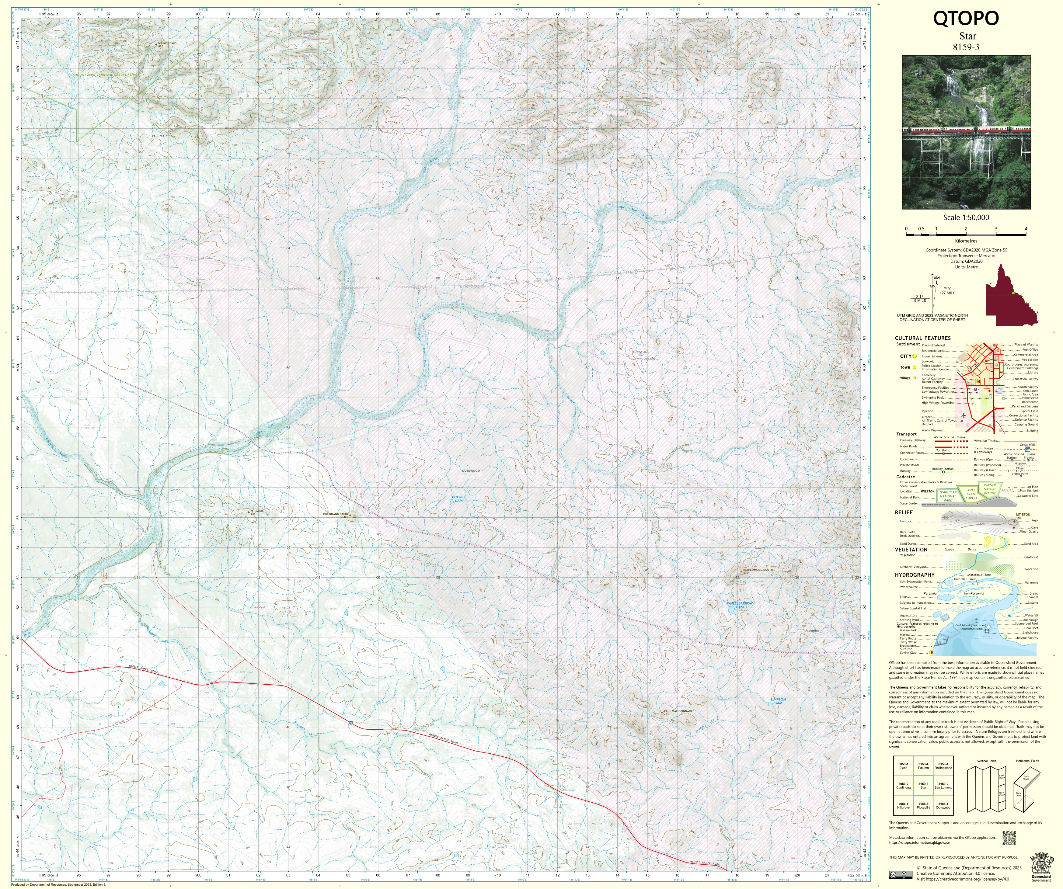
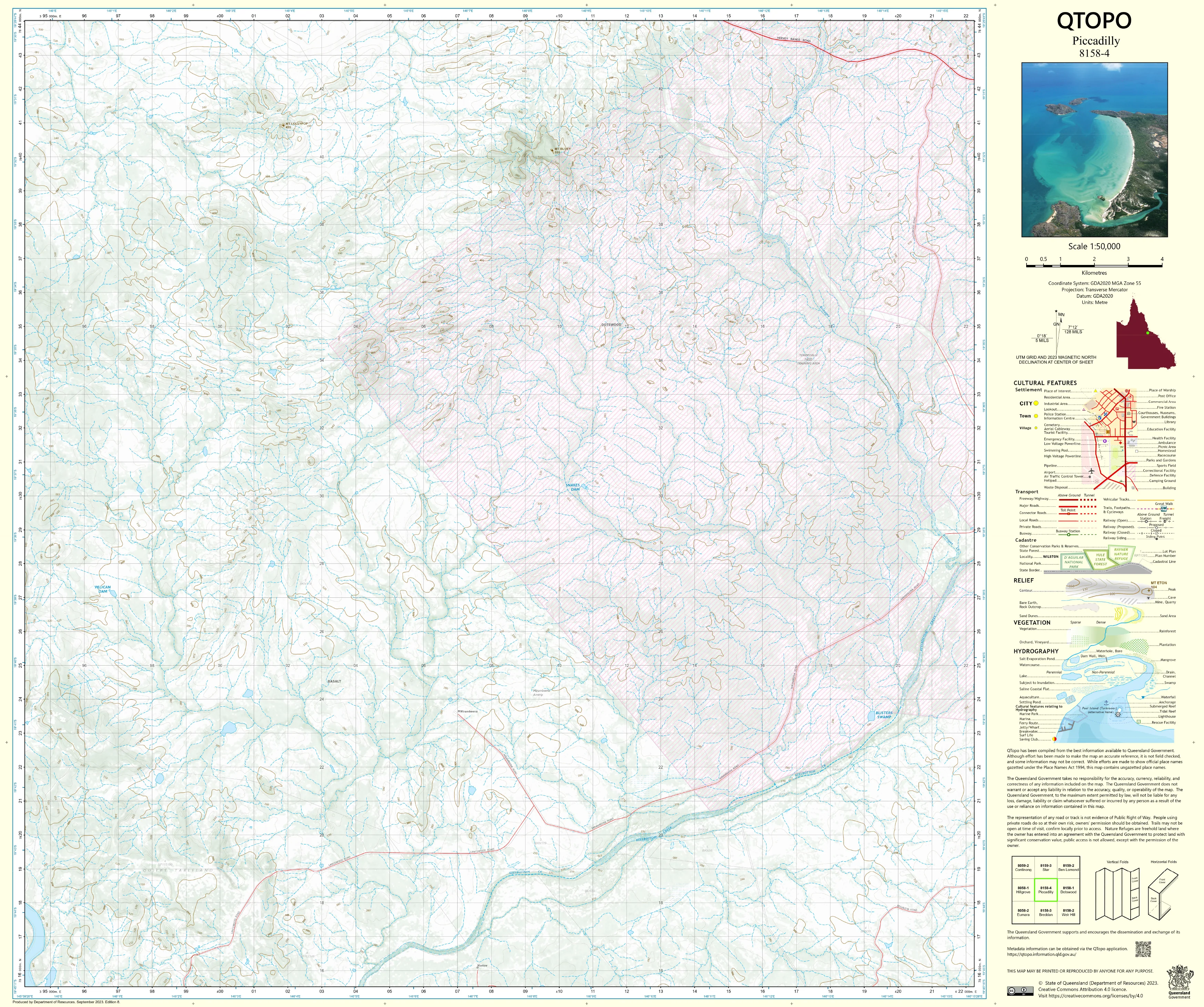
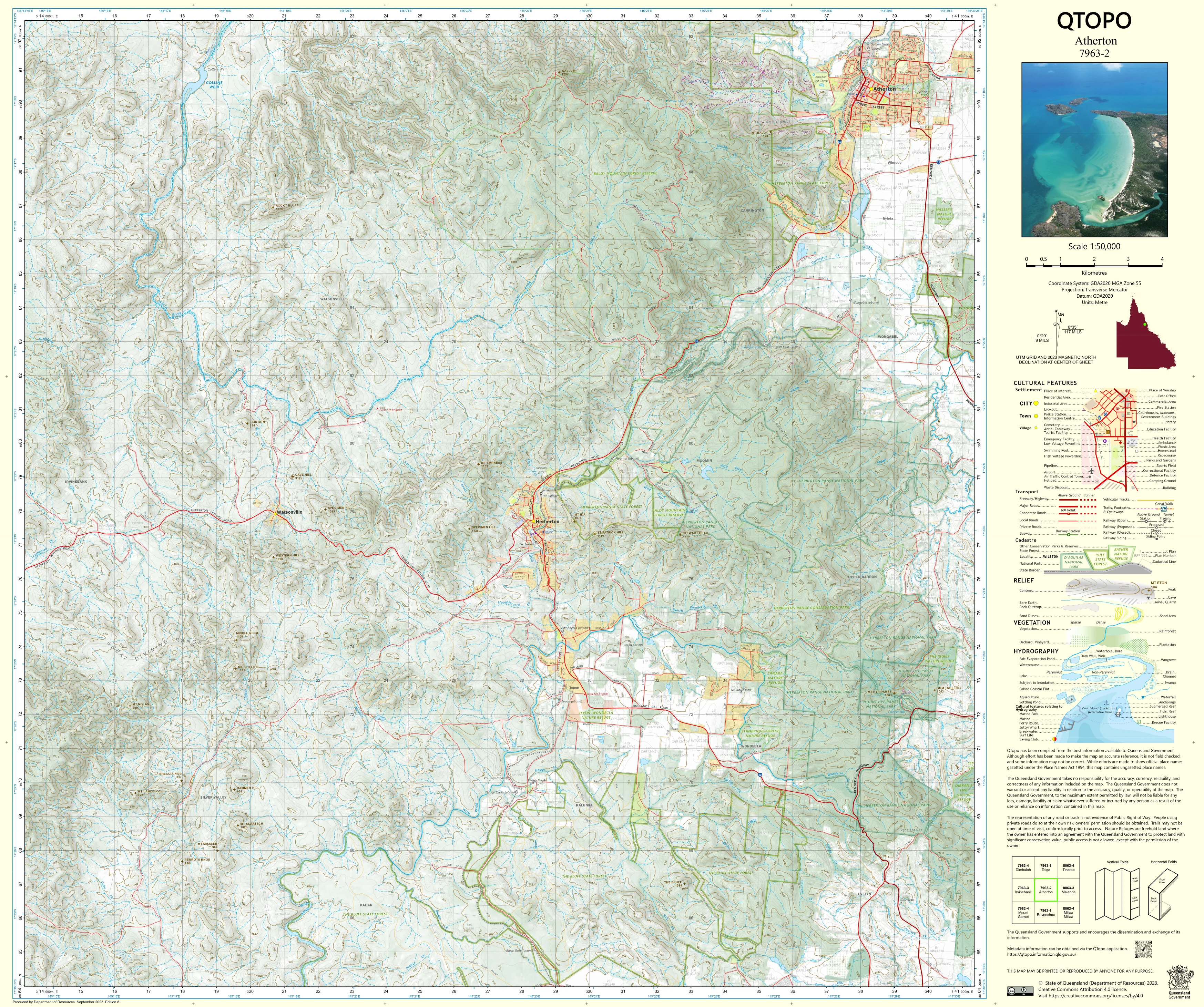
A detailed and authoritative topographic map covering the Indian Head region—one of K’gari (Fraser Island)’s most iconic locations, defined by sweeping sand dunes, freshwater lakes, coastal cliffs, rainforest pockets, and remote 4WD routes. This 1:50,000 QTopo sheet provides the essential clarity required for environmental monitoring, park management, visitor safety, cultural heritage protection, and navigation across this world-renowned sand island.
Produced by the Queensland Department of Resources, the QTopo 9547-1 (Indian Head) map features precise elevation modelling of dune systems, hydrology detail, walking tracks, 4WD access routes, vegetation layers, and land-tenure boundaries. Its mid-scale resolution is ideal for understanding the island’s constantly shifting landscapes, fragile ecosystems, and unique geomorphology.
Whether you're conducting ecological surveys, managing national park operations, mapping dune movement, or exploring the island’s remote beaches and inland tracks, this map provides dependable, high-quality geographic detail.
🗺️ Map Content and Features
At 1:50,000 scale—where 1 cm = 500 m—the map includes:
-
Contour lines depicting dune ridges, escarpments, swales, valleys, and elevated sand plateaus
-
Hydrology features: perched lakes, dune lakes, creeks, swamps, wetlands, and drainage paths
-
Roads & access routes: 4WD beach routes, inland soft-sand tracks, management roads, walking trails, and access points
-
Infrastructure: campgrounds, day-use areas, ranger bases, viewing points, communication sites, and key visitor facilities
-
Vegetation mapping: rainforest pockets, eucalypt woodland, coastal heath, dune vegetation, and wetland ecosystems
-
Land tenure boundaries: national park zones, recreation areas, Indigenous-protected areas, and managed sites
-
Named features: Indian Head, Champagne Pools, Middle Rocks, inland lakes, dune systems, coastal landmarks
-
Points of interest: essential for rangers, researchers, emergency crews, and visitors navigating remote island terrain
All mapping is derived from Queensland’s authoritative geospatial datasets for accuracy and reliability.
🧭 Who Uses This Map?
The Indian Head 9547-1 Topographic Map is essential for:
-
Environmental scientists & ecologists – dune stability studies, species monitoring, habitat mapping
-
National park managers & rangers – operational planning, visitor management, hazard assessment
-
Emergency services & SES – search and rescue, remote-area response, incident planning
-
Researchers & geomorphologists – coastal processes, freshwater lake systems, island geology
-
4WD tour operators & adventurers – safe navigation across beaches and inland tracks
-
Educators & students – conservation studies, field mapping, environmental geography
A critical reference for technical, operational, and recreational use on K’gari.
💧 Field-Ready Print Options
Select the finish that suits your environment:
✅ Waterproof & Tearproof Tyvek®
-
Printed on DuPont™ Tyvek®
-
Completely waterproof and tear-resistant
-
Ideal for beach conditions, salt spray, humidity, and sandy environments
✅ Laminated Edition
-
Encapsulated in 2 × 80-micron gloss laminate
-
Writeable surface for whiteboard markers
-
Resistant to moisture, dirt, salt, and heavy field use
📄 Standard Paper Edition
-
High-resolution printing
-
Perfect for planning, classroom use, and office reference
📐 Map Details
Title: QTopo 9547-1 — Indian Head
Publisher: Queensland Department of Resources
Series: QTopo 1:50,000
Scale: 1:50,000 (1 cm = 500 m)
Dimensions: 710 mm (width) × 594 mm (height)
Coverage: Indian Head, Champagne Pools, dune systems, lakes, rainforest patches, and remote beach/inland routes
Material Options: Paper, laminated, or waterproof Tyvek®
Printed in: Australia
Edition: Latest available
🛒 Ordering & Options
-
Folded paper map – lightweight and easy to pack
-
Waterproof Tyvek® edition – rugged and weatherproof for beach and dune environments
-
Laminated edition – reusable and ideal for planning and operational settings
🎯 Summary
The QTopo 9547-1 — Indian Head Topographic Map offers authoritative mapping of one of K’gari’s most striking and environmentally significant regions. With detailed dune modelling, hydrology mapping, and durable print options, it is indispensable for ecologists, rangers, emergency crews, researchers, and 4WD explorers.
Plan with purpose.
Navigate with confidence.
Explore with clarity.
Original: $14.27
-65%$14.27
$4.99Product Information
Product Information
Shipping & Returns
Shipping & Returns
Description
QTopo 9547-1 — Indian Head
1:50,000 Topographic Map
A detailed and authoritative topographic map covering the Indian Head region—one of K’gari (Fraser Island)’s most iconic locations, defined by sweeping sand dunes, freshwater lakes, coastal cliffs, rainforest pockets, and remote 4WD routes. This 1:50,000 QTopo sheet provides the essential clarity required for environmental monitoring, park management, visitor safety, cultural heritage protection, and navigation across this world-renowned sand island.
Produced by the Queensland Department of Resources, the QTopo 9547-1 (Indian Head) map features precise elevation modelling of dune systems, hydrology detail, walking tracks, 4WD access routes, vegetation layers, and land-tenure boundaries. Its mid-scale resolution is ideal for understanding the island’s constantly shifting landscapes, fragile ecosystems, and unique geomorphology.
Whether you're conducting ecological surveys, managing national park operations, mapping dune movement, or exploring the island’s remote beaches and inland tracks, this map provides dependable, high-quality geographic detail.
🗺️ Map Content and Features
At 1:50,000 scale—where 1 cm = 500 m—the map includes:
-
Contour lines depicting dune ridges, escarpments, swales, valleys, and elevated sand plateaus
-
Hydrology features: perched lakes, dune lakes, creeks, swamps, wetlands, and drainage paths
-
Roads & access routes: 4WD beach routes, inland soft-sand tracks, management roads, walking trails, and access points
-
Infrastructure: campgrounds, day-use areas, ranger bases, viewing points, communication sites, and key visitor facilities
-
Vegetation mapping: rainforest pockets, eucalypt woodland, coastal heath, dune vegetation, and wetland ecosystems
-
Land tenure boundaries: national park zones, recreation areas, Indigenous-protected areas, and managed sites
-
Named features: Indian Head, Champagne Pools, Middle Rocks, inland lakes, dune systems, coastal landmarks
-
Points of interest: essential for rangers, researchers, emergency crews, and visitors navigating remote island terrain
All mapping is derived from Queensland’s authoritative geospatial datasets for accuracy and reliability.
🧭 Who Uses This Map?
The Indian Head 9547-1 Topographic Map is essential for:
-
Environmental scientists & ecologists – dune stability studies, species monitoring, habitat mapping
-
National park managers & rangers – operational planning, visitor management, hazard assessment
-
Emergency services & SES – search and rescue, remote-area response, incident planning
-
Researchers & geomorphologists – coastal processes, freshwater lake systems, island geology
-
4WD tour operators & adventurers – safe navigation across beaches and inland tracks
-
Educators & students – conservation studies, field mapping, environmental geography
A critical reference for technical, operational, and recreational use on K’gari.
💧 Field-Ready Print Options
Select the finish that suits your environment:
✅ Waterproof & Tearproof Tyvek®
-
Printed on DuPont™ Tyvek®
-
Completely waterproof and tear-resistant
-
Ideal for beach conditions, salt spray, humidity, and sandy environments
✅ Laminated Edition
-
Encapsulated in 2 × 80-micron gloss laminate
-
Writeable surface for whiteboard markers
-
Resistant to moisture, dirt, salt, and heavy field use
📄 Standard Paper Edition
-
High-resolution printing
-
Perfect for planning, classroom use, and office reference
📐 Map Details
Title: QTopo 9547-1 — Indian Head
Publisher: Queensland Department of Resources
Series: QTopo 1:50,000
Scale: 1:50,000 (1 cm = 500 m)
Dimensions: 710 mm (width) × 594 mm (height)
Coverage: Indian Head, Champagne Pools, dune systems, lakes, rainforest patches, and remote beach/inland routes
Material Options: Paper, laminated, or waterproof Tyvek®
Printed in: Australia
Edition: Latest available
🛒 Ordering & Options
-
Folded paper map – lightweight and easy to pack
-
Waterproof Tyvek® edition – rugged and weatherproof for beach and dune environments
-
Laminated edition – reusable and ideal for planning and operational settings
🎯 Summary
The QTopo 9547-1 — Indian Head Topographic Map offers authoritative mapping of one of K’gari’s most striking and environmentally significant regions. With detailed dune modelling, hydrology mapping, and durable print options, it is indispensable for ecologists, rangers, emergency crews, researchers, and 4WD explorers.
Plan with purpose.
Navigate with confidence.
Explore with clarity.