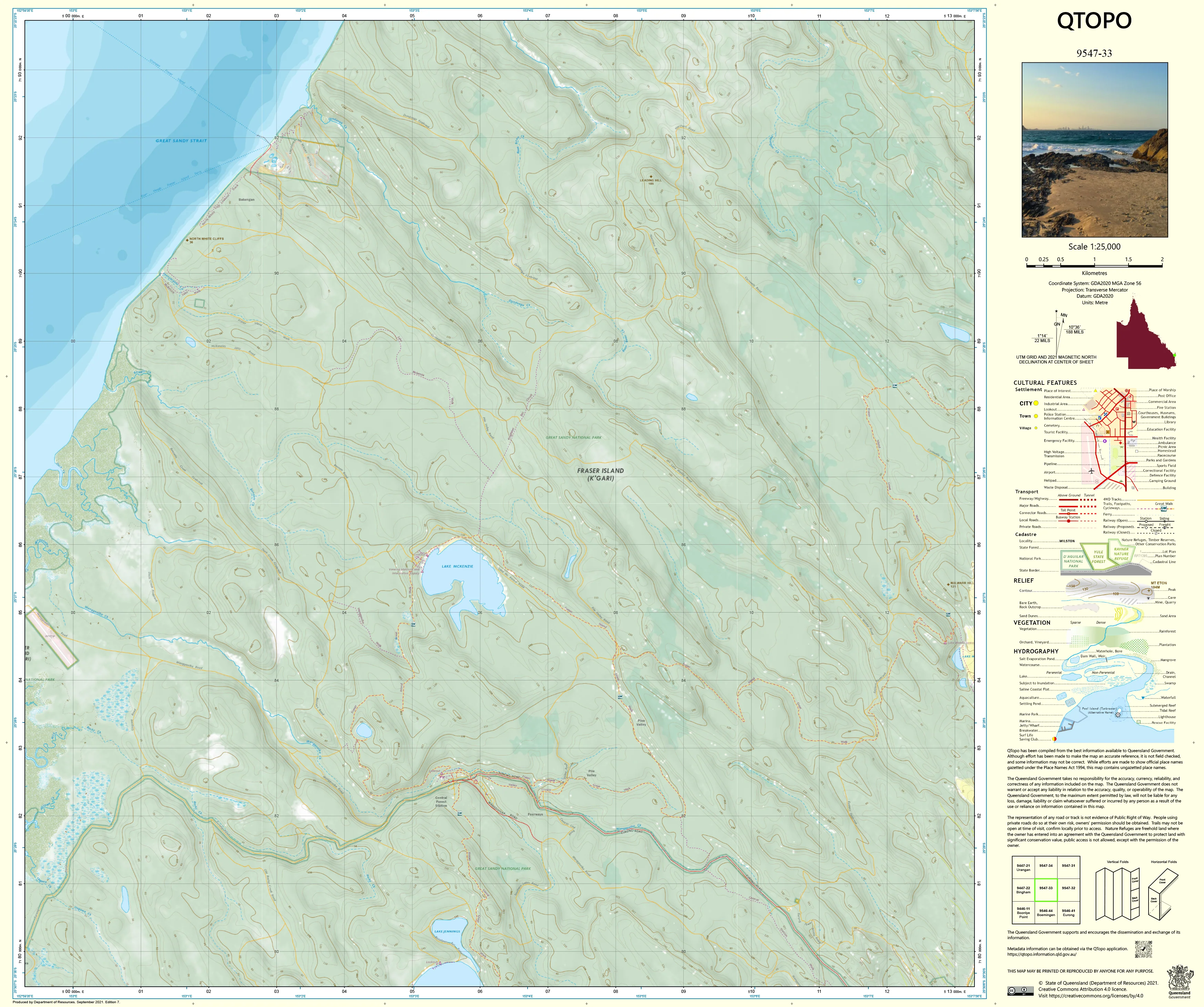
9547-33 QTopo 1:25,000 Topographic Map
QTopo 9547-33 — Topographic Map
1:25,000 Topographic Map
A detailed and authoritative topographic map from the Queensland Government’s QTopo 1:25,000 series, designed for precise navigation, planning, and fieldwork across a diverse mix of terrain. Whether the area includes rural landscapes, forested country, creek systems, agricultural land, or low-density settlements, this sheet delivers the clarity and accuracy needed for professional and recreational users alike.
The QTopo 9547-33 sheet—produced by the Queensland Department of Resources—provides reliable elevation data, hydrology networks, road and track detail, vegetation mapping, and land-tenure boundaries. Ideal for surveying, environmental analysis, land management, emergency operations, and outdoor exploration.
🗺️ Map Content and Features
At 1:25,000 scale—where 1 cm = 250 m—this map includes:
-
Contour lines showing hills, ridges, slopes, and valley floors
-
Hydrology detail: rivers, creeks, drainage lines, dams, wetlands, and catchment features
-
Roads & access routes including highways, rural roads, fire trails, 4WD tracks, and management roads
-
Infrastructure: powerlines, property boundaries, buildings, reservoirs, stockyards, and utility corridors
-
Vegetation mapping identifying forested areas, scrub, open woodland, grasslands, and cleared agricultural land
-
Land tenure boundaries: freehold parcels, state land, reserves, conservation areas, and easements
-
Named features such as hills, watercourses, reserves, rural localities, and geographic landmarks
-
Points of interest for landholders, rangers, surveyors, emergency services, and field researchers
Drawn from Queensland’s authoritative geospatial database for consistent, high-precision mapping.
🧭 Who Uses This Map?
The 9547-33 QTopo Topographic Map is ideal for:
-
Surveyors & planners – terrain assessment, land-use planning, boundary interpretation
-
Environmental & natural resource scientists – vegetation surveys, waterway analysis, ecology studies
-
Emergency services & SES – search & rescue, incident response, access planning
-
Farmers & land managers – property planning, access evaluation, landform understanding
-
Forestry & fire crews – fire trail navigation, hazard assessment, operations coordination
-
Bushwalkers & outdoor users – reliable navigation in remote or semi-remote terrain
-
Educators & students – geography, mapping, and field science
A versatile and essential tool for a wide range of professional and outdoor applications.
💧 Field-Ready Print Options
Choose the finish best suited to your work environment:
✅ Waterproof & Tearproof Tyvek®
-
Printed on DuPont™ Tyvek®
-
Fully waterproof, durable, and tear-resistant
-
Ideal for rugged, wet, or high-humidity fieldwork
✅ Laminated Edition
-
Encapsulated in 2 × 80-micron gloss laminate
-
Writeable surface for whiteboard markers
-
Resistant to moisture, mud, oils, and heavy handling
📄 Standard Paper Edition
-
Crisp, high-resolution print
-
Ideal for office reference, planning, and education
📐 Map Details
Title: QTopo 9547-33 — Topographic Map
Publisher: Queensland Department of Resources
Series: QTopo 1:25,000
Scale: 1:25,000 (1 cm = 250 m)
Dimensions: 710 mm (width) × 594 mm (height)
Coverage: Regional terrain including waterways, access routes, land parcels, vegetation, and natural features (specific locality varies by sheet)
Material Options: Paper, laminated, or waterproof Tyvek®
Printed in: Australia
Edition: Latest available
📥 QTopo Map Index
Need to find adjoining sheets?
➡️ Provide surrounding sheet numbers and I’ll identify all adjacent maps instantly.
🛒 Ordering & Options
-
Folded paper map – ideal for everyday reference
-
Waterproof Tyvek® edition – best for rugged outdoor conditions
-
Laminated edition – durable and reusable
-
Flat (unfolded) maps – for wall mounting or planning boards
🎯 Summary
The QTopo 9547-33 Topographic Map provides reliable, detailed information on terrain, hydrology, vegetation, infrastructure, and land use. With its authoritative 1:25,000 scale and durable print options, it is indispensable for surveyors, planners, ecologists, emergency crews, land managers, and outdoor enthusiasts.
Plan with purpose.
Navigate with confidence.
Explore with clarity.
Choose your preferred finish today and put Queensland’s most trusted topographic map to work.
Product Information
Product Information
Shipping & Returns
Shipping & Returns
Description
QTopo 9547-33 — Topographic Map
1:25,000 Topographic Map
A detailed and authoritative topographic map from the Queensland Government’s QTopo 1:25,000 series, designed for precise navigation, planning, and fieldwork across a diverse mix of terrain. Whether the area includes rural landscapes, forested country, creek systems, agricultural land, or low-density settlements, this sheet delivers the clarity and accuracy needed for professional and recreational users alike.
The QTopo 9547-33 sheet—produced by the Queensland Department of Resources—provides reliable elevation data, hydrology networks, road and track detail, vegetation mapping, and land-tenure boundaries. Ideal for surveying, environmental analysis, land management, emergency operations, and outdoor exploration.
🗺️ Map Content and Features
At 1:25,000 scale—where 1 cm = 250 m—this map includes:
-
Contour lines showing hills, ridges, slopes, and valley floors
-
Hydrology detail: rivers, creeks, drainage lines, dams, wetlands, and catchment features
-
Roads & access routes including highways, rural roads, fire trails, 4WD tracks, and management roads
-
Infrastructure: powerlines, property boundaries, buildings, reservoirs, stockyards, and utility corridors
-
Vegetation mapping identifying forested areas, scrub, open woodland, grasslands, and cleared agricultural land
-
Land tenure boundaries: freehold parcels, state land, reserves, conservation areas, and easements
-
Named features such as hills, watercourses, reserves, rural localities, and geographic landmarks
-
Points of interest for landholders, rangers, surveyors, emergency services, and field researchers
Drawn from Queensland’s authoritative geospatial database for consistent, high-precision mapping.
🧭 Who Uses This Map?
The 9547-33 QTopo Topographic Map is ideal for:
-
Surveyors & planners – terrain assessment, land-use planning, boundary interpretation
-
Environmental & natural resource scientists – vegetation surveys, waterway analysis, ecology studies
-
Emergency services & SES – search & rescue, incident response, access planning
-
Farmers & land managers – property planning, access evaluation, landform understanding
-
Forestry & fire crews – fire trail navigation, hazard assessment, operations coordination
-
Bushwalkers & outdoor users – reliable navigation in remote or semi-remote terrain
-
Educators & students – geography, mapping, and field science
A versatile and essential tool for a wide range of professional and outdoor applications.
💧 Field-Ready Print Options
Choose the finish best suited to your work environment:
✅ Waterproof & Tearproof Tyvek®
-
Printed on DuPont™ Tyvek®
-
Fully waterproof, durable, and tear-resistant
-
Ideal for rugged, wet, or high-humidity fieldwork
✅ Laminated Edition
-
Encapsulated in 2 × 80-micron gloss laminate
-
Writeable surface for whiteboard markers
-
Resistant to moisture, mud, oils, and heavy handling
📄 Standard Paper Edition
-
Crisp, high-resolution print
-
Ideal for office reference, planning, and education
📐 Map Details
Title: QTopo 9547-33 — Topographic Map
Publisher: Queensland Department of Resources
Series: QTopo 1:25,000
Scale: 1:25,000 (1 cm = 250 m)
Dimensions: 710 mm (width) × 594 mm (height)
Coverage: Regional terrain including waterways, access routes, land parcels, vegetation, and natural features (specific locality varies by sheet)
Material Options: Paper, laminated, or waterproof Tyvek®
Printed in: Australia
Edition: Latest available
📥 QTopo Map Index
Need to find adjoining sheets?
➡️ Provide surrounding sheet numbers and I’ll identify all adjacent maps instantly.
🛒 Ordering & Options
-
Folded paper map – ideal for everyday reference
-
Waterproof Tyvek® edition – best for rugged outdoor conditions
-
Laminated edition – durable and reusable
-
Flat (unfolded) maps – for wall mounting or planning boards
🎯 Summary
The QTopo 9547-33 Topographic Map provides reliable, detailed information on terrain, hydrology, vegetation, infrastructure, and land use. With its authoritative 1:25,000 scale and durable print options, it is indispensable for surveyors, planners, ecologists, emergency crews, land managers, and outdoor enthusiasts.
Plan with purpose.
Navigate with confidence.
Explore with clarity.
Choose your preferred finish today and put Queensland’s most trusted topographic map to work.


