A Traveler's Map of the Alps - Published 1985 by National Geographic
A Traveler’s Map of the Alps (1985)
Publisher: National Geographic
Published: 1985
Size: 570 mm (W) × 912 mm (H)
Orientation: Portrait
Map Type: Historical Thematic Travel Map
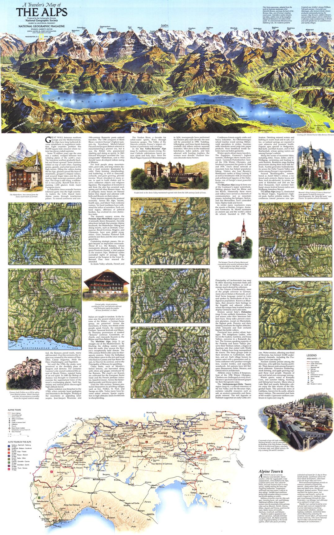
Published in 1985, A Traveler’s Map of the Alps is a richly layered travel and thematic map celebrating Europe’s most iconic mountain range. Designed for explorers, planners, and armchair travellers alike, it combines practical touring information with dramatic alpine artistry, capturing National Geographic’s late-20th-century cartography at its finest.
The upper portion of the map is dominated by a sweeping Swiss alpine panorama, adapted from the work of renowned Austrian landscape artist Heinrich Berann. Centred on the Bernese Alps, the illustration conveys elevation, scale, and grandeur in a way few maps can — blending scientific geography with painterly relief.
Issued as one half of a two-map set, this sheet focuses on travel routes, touring distances, and regional detail, while its companion map presents a dedicated relief view of the Alps.
🏔️ What This Map Shows
-
Alpine auto touring routes across multiple countries
-
Distances between key alpine destinations
-
Points of interest for travellers and explorers
-
Seven detailed inset maps of specific alpine regions
-
A panoramic illustration highlighting the heart of the Bernese Alps
The result is a map that balances big-picture alpine geography with region-by-region clarity.
🧭 Designed for Travellers
This is not a purely physical or political map — it was created for movement and discovery:
-
Emphasises road access and touring corridors
-
Highlights resort regions and alpine passes
-
Supports cross-border travel planning
-
Reflects the golden era of pre-digital, map-led travel
It captures a time when unfolding a map was the first step of any great journey.
🎨 Materials, Print Quality & Hanging Options
📄 Paper (Classic Framing Option)
-
Printed on high-quality matte paper for crisp detail and accurate colour
-
Smooth, low-glare surface — ideal for framing under glass
-
A traditional choice for studies, libraries, and travel-inspired interiors
🔒 Laminated (Write-On / Wipe-Off)
-
Printed on quality paper and encapsulated in protective laminate
-
Durable, waterproof, and tear-resistant
-
Write-on / wipe-off surface compatible with whiteboard markers and map dots
-
Ideal for planning trips, teaching, and interactive use
🪵 Optional Timber Hang Rails — Laminated
-
Top and bottom natural timber rails provide structure and balance
-
Bottom rail adds weight so the map hangs flat and straight
-
Prevents edge curl and long-term sagging
-
Supplied with hanging cord — ready to mount on a single hook
Please allow up to 10 working days for laminated maps with hang rails.
🎨 Archival Canvas (Premium Display Option)
-
Printed on 395 gsm HP Professional Matte Canvas
-
Subtle canvas texture enhances colour depth while retaining fine line detail
-
Matte surface reduces reflections compared with glass-framed prints
Archival Pigment Inks
-
Produced using Hewlett-Packard archival, fade-resistant pigment inks
-
Ensures crisp typography, stable colour, and long-term durability
-
Designed to remain vibrant and legible for many years
🪵 Optional Timber Hang Rails — Canvas
-
Top and bottom timber rails create a clean, gallery-style presentation
-
Bottom rail adds weight for a perfectly straight hang
-
Prevents edge curl and sag over time
-
Supplied with hanging cord — ready to mount
Please allow up to 10 working days for canvas maps with hang rails.
Canvas editions are intended for display and reference and are not write-on / wipe-off like laminated versions.
📐 Size & Format
-
Size: 570 mm × 912 mm
-
Orientation: Portrait
A wall-friendly size that allows both the alpine panorama and regional insets to be appreciated without overwhelming the space.
📊 Specifications
| Attribute | Details |
|---|---|
| Title | A Traveler’s Map of the Alps |
| Publisher | National Geographic |
| Year | 1985 |
| Coverage | The European Alps |
| Map Type | Thematic travel map |
| Features | Touring routes, distances, points of interest, regional insets |
| Artwork | Alpine panorama adapted from Heinrich Berann |
| Available Formats | Paper • Laminated • Laminated + Hang Rails • Canvas • Canvas + Hang Rails |
| Canvas Weight | 395 gsm HP Professional Matte |
| Inks (Canvas) | Hewlett-Packard archival, fade-resistant pigment inks |
| Size | 570 mm × 912 mm |
| Collections | Europe • Historical • Regional • Thematic Maps |
🎯 Who It’s For
-
🏔️ Alpine and European travel enthusiasts
-
🗺️ Collectors of National Geographic maps
-
🎓 Educators & libraries — travel geography and alpine studies
-
🏠 Homes & studies — refined, travel-inspired wall décor
-
🎁 Gift buyers — evocative, intelligent, and timeless
🤝 Our Commitment
This classic National Geographic map is reproduced and printed in Australia with careful attention to colour, clarity, and finish. Each map is checked and packed with care, ensuring it arrives ready to inspire exploration.
🛒 Plan the Alps the classic way — choose Paper, Laminated, or Canvas, with optional timber hang rails, and order A Traveler’s Map of the Alps (1985) today.
Product Information
Product Information
Shipping & Returns
Shipping & Returns
Description
A Traveler’s Map of the Alps (1985)
Publisher: National Geographic
Published: 1985
Size: 570 mm (W) × 912 mm (H)
Orientation: Portrait
Map Type: Historical Thematic Travel Map
Published in 1985, A Traveler’s Map of the Alps is a richly layered travel and thematic map celebrating Europe’s most iconic mountain range. Designed for explorers, planners, and armchair travellers alike, it combines practical touring information with dramatic alpine artistry, capturing National Geographic’s late-20th-century cartography at its finest.
The upper portion of the map is dominated by a sweeping Swiss alpine panorama, adapted from the work of renowned Austrian landscape artist Heinrich Berann. Centred on the Bernese Alps, the illustration conveys elevation, scale, and grandeur in a way few maps can — blending scientific geography with painterly relief.
Issued as one half of a two-map set, this sheet focuses on travel routes, touring distances, and regional detail, while its companion map presents a dedicated relief view of the Alps.
🏔️ What This Map Shows
-
Alpine auto touring routes across multiple countries
-
Distances between key alpine destinations
-
Points of interest for travellers and explorers
-
Seven detailed inset maps of specific alpine regions
-
A panoramic illustration highlighting the heart of the Bernese Alps
The result is a map that balances big-picture alpine geography with region-by-region clarity.
🧭 Designed for Travellers
This is not a purely physical or political map — it was created for movement and discovery:
-
Emphasises road access and touring corridors
-
Highlights resort regions and alpine passes
-
Supports cross-border travel planning
-
Reflects the golden era of pre-digital, map-led travel
It captures a time when unfolding a map was the first step of any great journey.
🎨 Materials, Print Quality & Hanging Options
📄 Paper (Classic Framing Option)
-
Printed on high-quality matte paper for crisp detail and accurate colour
-
Smooth, low-glare surface — ideal for framing under glass
-
A traditional choice for studies, libraries, and travel-inspired interiors
🔒 Laminated (Write-On / Wipe-Off)
-
Printed on quality paper and encapsulated in protective laminate
-
Durable, waterproof, and tear-resistant
-
Write-on / wipe-off surface compatible with whiteboard markers and map dots
-
Ideal for planning trips, teaching, and interactive use
🪵 Optional Timber Hang Rails — Laminated
-
Top and bottom natural timber rails provide structure and balance
-
Bottom rail adds weight so the map hangs flat and straight
-
Prevents edge curl and long-term sagging
-
Supplied with hanging cord — ready to mount on a single hook
Please allow up to 10 working days for laminated maps with hang rails.
🎨 Archival Canvas (Premium Display Option)
-
Printed on 395 gsm HP Professional Matte Canvas
-
Subtle canvas texture enhances colour depth while retaining fine line detail
-
Matte surface reduces reflections compared with glass-framed prints
Archival Pigment Inks
-
Produced using Hewlett-Packard archival, fade-resistant pigment inks
-
Ensures crisp typography, stable colour, and long-term durability
-
Designed to remain vibrant and legible for many years
🪵 Optional Timber Hang Rails — Canvas
-
Top and bottom timber rails create a clean, gallery-style presentation
-
Bottom rail adds weight for a perfectly straight hang
-
Prevents edge curl and sag over time
-
Supplied with hanging cord — ready to mount
Please allow up to 10 working days for canvas maps with hang rails.
Canvas editions are intended for display and reference and are not write-on / wipe-off like laminated versions.
📐 Size & Format
-
Size: 570 mm × 912 mm
-
Orientation: Portrait
A wall-friendly size that allows both the alpine panorama and regional insets to be appreciated without overwhelming the space.
📊 Specifications
| Attribute | Details |
|---|---|
| Title | A Traveler’s Map of the Alps |
| Publisher | National Geographic |
| Year | 1985 |
| Coverage | The European Alps |
| Map Type | Thematic travel map |
| Features | Touring routes, distances, points of interest, regional insets |
| Artwork | Alpine panorama adapted from Heinrich Berann |
| Available Formats | Paper • Laminated • Laminated + Hang Rails • Canvas • Canvas + Hang Rails |
| Canvas Weight | 395 gsm HP Professional Matte |
| Inks (Canvas) | Hewlett-Packard archival, fade-resistant pigment inks |
| Size | 570 mm × 912 mm |
| Collections | Europe • Historical • Regional • Thematic Maps |
🎯 Who It’s For
-
🏔️ Alpine and European travel enthusiasts
-
🗺️ Collectors of National Geographic maps
-
🎓 Educators & libraries — travel geography and alpine studies
-
🏠 Homes & studies — refined, travel-inspired wall décor
-
🎁 Gift buyers — evocative, intelligent, and timeless
🤝 Our Commitment
This classic National Geographic map is reproduced and printed in Australia with careful attention to colour, clarity, and finish. Each map is checked and packed with care, ensuring it arrives ready to inspire exploration.
🛒 Plan the Alps the classic way — choose Paper, Laminated, or Canvas, with optional timber hang rails, and order A Traveler’s Map of the Alps (1985) today.


