A World Transformed — Eastern North America (2007)
Publisher: National Geographic
Published: May 2007
Scale: 1 : 4,560,000
Size: 511 mm (W) × 790 mm (H)
Orientation: Portrait
Map Type: Historical & Thematic Comparison Map
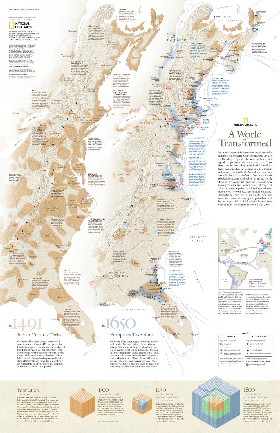
A World Transformed is a powerful, visually driven thematic map that reveals the profound demographic changes that reshaped eastern North America following European contact. Presented as a pair of comparative maps, it contrasts Native American and European populations along the Atlantic seaboard in 1491 and 1650, offering a stark visual narrative of transformation, displacement, and expansion.
Published in 2007, this map uses National Geographic’s signature blend of cartographic authority and graphic storytelling to make complex historical change immediately understandable. Population graphics further trace demographic shifts from 1500 to 1800, placing early contact within a broader, long-term historical context.
This sheet forms one half of a two-map set. Its companion map, 1607: When Cultures Collide, explores the moment of first sustained contact in greater detail and is available separately.
🗺️ What This Map Shows
-
Comparative population maps of eastern North America in 1491 and 1650
-
Visual contrast between Native American and European population distributions
-
Population graphics illustrating demographic change from 1500 to 1800
-
Coastal regions, river systems, and early colonial centres for geographic context
The side-by-side comparison makes the scale and speed of change unmistakable.
🕰️ Historical Context
-
1491 — A continent shaped by thousands of years of Indigenous settlement and land management
-
1650 — A rapidly changing landscape influenced by European colonisation, disease, and migration
-
Highlights the demographic consequences of contact rather than focusing solely on political events
-
Encourages a deeper understanding of North American history through population and place
This is a map designed not just to inform, but to provoke reflection.
🎨 Cartography & Graphic Storytelling
-
Clear, restrained base mapping ensures focus remains on the population data
-
Thoughtful colour and symbol use distinguishes cultures without visual clutter
-
A hallmark example of National Geographic’s late-20th / early-21st century thematic cartography
The result is a map that works equally well in classrooms, libraries, museums, and thoughtful home collections.
🎨 Materials, Print Quality & Hanging Options
📄 Paper (Classic Framing Option)
-
Printed on high-quality matte paper for crisp graphics and legible typography
-
Smooth, low-glare surface — ideal for framing under glass
-
A traditional option for libraries, studies, and educational spaces
🔒 Laminated (Write-On / Wipe-Off)
-
Printed on quality paper and encapsulated in protective laminate
-
Durable, waterproof, and tear-resistant
-
Write-on / wipe-off surface compatible with whiteboard markers and map dots
-
Ideal for classrooms, teaching, and discussion-based use
🪵 Optional Timber Hang Rails — Laminated
-
Top and bottom natural timber rails provide structure and balance
-
Bottom rail adds weight so the map hangs flat and straight
-
Prevents edge curl and long-term sagging
-
Supplied with hanging cord — ready to mount on a single hook
Please allow up to 10 working days for laminated maps with hang rails.
🎨 Archival Canvas (Premium Display Option)
-
Printed on 395 gsm HP Professional Matte Canvas
-
Subtle canvas texture adds depth while preserving fine graphic detail
-
Matte surface reduces reflections compared with glass-framed prints
Archival Pigment Inks
-
Produced using Hewlett-Packard archival, fade-resistant pigment inks
-
Ensures stable colour, crisp graphics, and long-term durability
🪵 Optional Timber Hang Rails — Canvas
-
Top and bottom timber rails create a clean, gallery-style presentation
-
Bottom rail adds weight for a perfectly straight hang
-
Prevents edge curl and sag over time
-
Supplied with hanging cord — ready to mount
Please allow up to 10 working days for canvas maps with hang rails.
Canvas editions are intended for display and reference and are not write-on / wipe-off like laminated versions.
📐 Size & Scale
-
Size: 511 mm × 790 mm
-
Scale: 1 : 4,560,000
A balanced, wall-friendly size that suits classrooms, libraries, and thoughtful home displays.
📊 Specifications
| Attribute | Details |
|---|---|
| Title | A World Transformed |
| Publisher | National Geographic |
| Year | 2007 |
| Coverage | Eastern North America |
| Map Type | Historical & thematic |
| Features | Comparative population maps (1491 & 1650), population change graphics (1500–1800) |
| Companion Map | 1607: When Cultures Collide |
| Scale | 1 : 4,560,000 |
| Available Formats | Paper • Laminated • Laminated + Hang Rails • Canvas • Canvas + Hang Rails |
| Canvas Weight | 395 gsm HP Professional Matte |
| Inks (Canvas) | Hewlett-Packard archival, fade-resistant pigment inks |
| Size | 511 mm × 790 mm |
| Orientation | Portrait |
🎯 Who It’s For
-
🏛️ Educators & historians — teaching contact-era North American history
-
🎓 Universities & libraries — thematic and demographic analysis
-
🗺️ National Geographic collectors — a standout modern historical map
-
🏠 Thoughtful home displays — intellectually engaging wall art
-
🎁 Gift buyers — meaningful, conversation-starting cartography
🤝 Our Commitment
This National Geographic map is reproduced and printed in Australia with careful attention to clarity, colour, and finish. Each copy is checked and packed with care, ensuring it arrives ready to inform, challenge, and endure.
🛒 See history through change, not just dates — choose Paper, Laminated, or Canvas, with optional timber hang rails, and order A World Transformed (2007) today.


