Above the Rockies - Published 1995 by National Geographic
Satellite Map | Rocky Mountains from Space | Large Wall Format (792 × 513 mm) | Premium Finishes
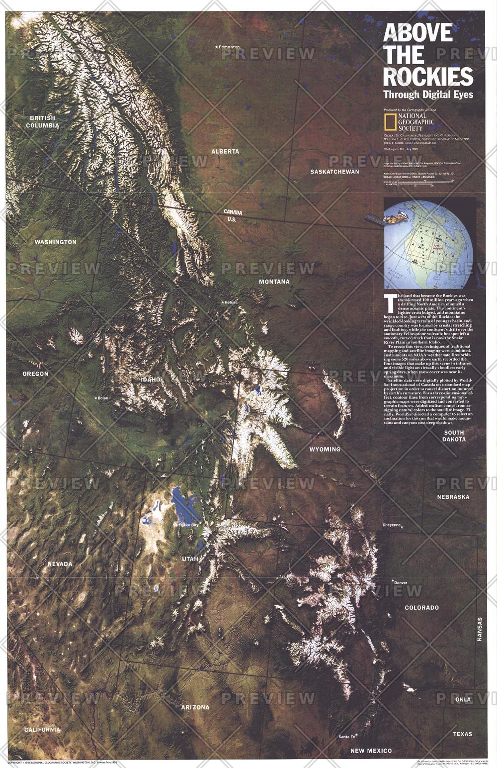
A breathtaking view of North America’s great mountain backbone, Above the Rockies presents the Rocky Mountains as seen from space. Published by National Geographic in July 1995, this striking map is based on NOAA satellite imagery, enhanced using advanced processing by WorldSat International.
Created as a companion to Heart of the Rockies, it transforms raw satellite data into a vivid and highly detailed portrait of one of the world’s most iconic mountain systems—revealing terrain, scale, and structure in a way traditional maps cannot.
Why This Map Stands Out
A true satellite perspective
Built from NOAA imagery, offering an authentic view of the Rockies from above.
Enhanced for clarity and impact
Digitally refined to highlight terrain, elevation, and landscape features.
A different way to see mountains
Moves beyond contour lines to show the Rockies as a continuous, living system.
National Geographic authority
Combines scientific accuracy with striking visual presentation.
A dramatic wall display
Perfect as both an educational reference and a bold decorative piece.
🗺️ What the Map Shows
- The full sweep of the Rocky Mountain range across North America
- Natural colour satellite imagery revealing mountains, valleys, and plateaus
- Major geographic features including rivers, forests, and alpine regions
- The relationship between elevation, terrain, and landscape patterns
- A visual sense of the Rockies as a continuous continental spine
- Subtle variations in land cover and geology visible from space
📐 Size & Format
792 mm (W) × 513 mm (H)
Landscape orientation
A balanced, visually striking format ideal for:
- Home offices and studies
- Classrooms and geography departments
- Adventure and outdoor-themed interiors
- Feature walls celebrating natural landscapes
✨ Premium Finishes
| Format | Description |
|---|---|
| 📜 Paper (160 gsm) | Heavyweight matte-coated paper—ideal for framing. Preserves fine satellite detail and colour variation. |
| 🧼 Laminated (Encapsulated) | Sealed in 2 × 80-micron gloss laminate. Durable, wipe-clean, and ideal for regular reference. |
| 🪵 Laminated + Timber Hang Rails | Laminated map mounted with lacquered natural timber rails and hanging cord—ready to display. |
| 🖼️ Canvas (395 gsm HP Professional Matte) | Printed with archival pigment inks. Rich texture enhances depth and visual presence. |
| 🪵 Canvas + Timber Hang Rails | Canvas paired with timber rails for a refined, gallery-style presentation. |
🔨 Please allow up to 10 working days for professionally mounted hang-railed finishes.
📊 Specifications
| Feature | Detail |
|---|---|
| Title | Above the Rockies |
| Publisher | National Geographic |
| Published | 1995 |
| Dimensions | 792 mm × 513 mm |
| Orientation | Landscape |
| Map Type | Satellite / Physical |
| Coverage | Rocky Mountains, North America |
| Collections | North America, Historical |
| Materials | 160 gsm matte paper / 2 × 80-micron laminate / 395 gsm HP Professional Matte Canvas |
| Printing | Pigment-based, fade-resistant inks |
| Origin | Printed in Australia |
🎯 Ideal For
- Outdoor enthusiasts and lovers of mountain landscapes
- Students and educators of geography and earth science
- Collectors of National Geographic satellite maps
- Interiors inspired by nature and exploration
- Gift buyers seeking a visually striking and educational map
🏔️ A Continental Spine from Above
Seen from space, the Rockies reveal their true scale:
- A vast mountain chain stretching across continents
- Valleys, ridges, and plateaus forming intricate patterns
- Landscapes shaped by uplift, erosion, and time
- A natural system that defines the geography of North America
This map captures that perspective—offering a view that is both scientific and awe-inspiring.
🤝 Our Commitment
- Printed in Australia using archival-quality production
- Faithfully reproduced to preserve clarity and satellite detail
- Premium materials selected for durability and long-term display
- Each map is hand-checked before dispatch
- Carefully packaged for safe delivery
🚚 Delivery
- Paper, Laminated, Canvas (rolled): Dispatch within 1–2 business days
- Hang-Railed Maps: Made to order—allow up to 10 working days
- Packaging: Securely rolled in protective tubing
See the Rockies as few ever do—
a map that brings mountains into breathtaking perspective.
👉 Order now and elevate your wall with a view from space.
Original: $57.20
-65%$57.20
$20.02Product Information
Product Information
Shipping & Returns
Shipping & Returns
Description
Satellite Map | Rocky Mountains from Space | Large Wall Format (792 × 513 mm) | Premium Finishes
A breathtaking view of North America’s great mountain backbone, Above the Rockies presents the Rocky Mountains as seen from space. Published by National Geographic in July 1995, this striking map is based on NOAA satellite imagery, enhanced using advanced processing by WorldSat International.
Created as a companion to Heart of the Rockies, it transforms raw satellite data into a vivid and highly detailed portrait of one of the world’s most iconic mountain systems—revealing terrain, scale, and structure in a way traditional maps cannot.
Why This Map Stands Out
A true satellite perspective
Built from NOAA imagery, offering an authentic view of the Rockies from above.
Enhanced for clarity and impact
Digitally refined to highlight terrain, elevation, and landscape features.
A different way to see mountains
Moves beyond contour lines to show the Rockies as a continuous, living system.
National Geographic authority
Combines scientific accuracy with striking visual presentation.
A dramatic wall display
Perfect as both an educational reference and a bold decorative piece.
🗺️ What the Map Shows
- The full sweep of the Rocky Mountain range across North America
- Natural colour satellite imagery revealing mountains, valleys, and plateaus
- Major geographic features including rivers, forests, and alpine regions
- The relationship between elevation, terrain, and landscape patterns
- A visual sense of the Rockies as a continuous continental spine
- Subtle variations in land cover and geology visible from space
📐 Size & Format
792 mm (W) × 513 mm (H)
Landscape orientation
A balanced, visually striking format ideal for:
- Home offices and studies
- Classrooms and geography departments
- Adventure and outdoor-themed interiors
- Feature walls celebrating natural landscapes
✨ Premium Finishes
| Format | Description |
|---|---|
| 📜 Paper (160 gsm) | Heavyweight matte-coated paper—ideal for framing. Preserves fine satellite detail and colour variation. |
| 🧼 Laminated (Encapsulated) | Sealed in 2 × 80-micron gloss laminate. Durable, wipe-clean, and ideal for regular reference. |
| 🪵 Laminated + Timber Hang Rails | Laminated map mounted with lacquered natural timber rails and hanging cord—ready to display. |
| 🖼️ Canvas (395 gsm HP Professional Matte) | Printed with archival pigment inks. Rich texture enhances depth and visual presence. |
| 🪵 Canvas + Timber Hang Rails | Canvas paired with timber rails for a refined, gallery-style presentation. |
🔨 Please allow up to 10 working days for professionally mounted hang-railed finishes.
📊 Specifications
| Feature | Detail |
|---|---|
| Title | Above the Rockies |
| Publisher | National Geographic |
| Published | 1995 |
| Dimensions | 792 mm × 513 mm |
| Orientation | Landscape |
| Map Type | Satellite / Physical |
| Coverage | Rocky Mountains, North America |
| Collections | North America, Historical |
| Materials | 160 gsm matte paper / 2 × 80-micron laminate / 395 gsm HP Professional Matte Canvas |
| Printing | Pigment-based, fade-resistant inks |
| Origin | Printed in Australia |
🎯 Ideal For
- Outdoor enthusiasts and lovers of mountain landscapes
- Students and educators of geography and earth science
- Collectors of National Geographic satellite maps
- Interiors inspired by nature and exploration
- Gift buyers seeking a visually striking and educational map
🏔️ A Continental Spine from Above
Seen from space, the Rockies reveal their true scale:
- A vast mountain chain stretching across continents
- Valleys, ridges, and plateaus forming intricate patterns
- Landscapes shaped by uplift, erosion, and time
- A natural system that defines the geography of North America
This map captures that perspective—offering a view that is both scientific and awe-inspiring.
🤝 Our Commitment
- Printed in Australia using archival-quality production
- Faithfully reproduced to preserve clarity and satellite detail
- Premium materials selected for durability and long-term display
- Each map is hand-checked before dispatch
- Carefully packaged for safe delivery
🚚 Delivery
- Paper, Laminated, Canvas (rolled): Dispatch within 1–2 business days
- Hang-Railed Maps: Made to order—allow up to 10 working days
- Packaging: Securely rolled in protective tubing
See the Rockies as few ever do—
a map that brings mountains into breathtaking perspective.
👉 Order now and elevate your wall with a view from space.


