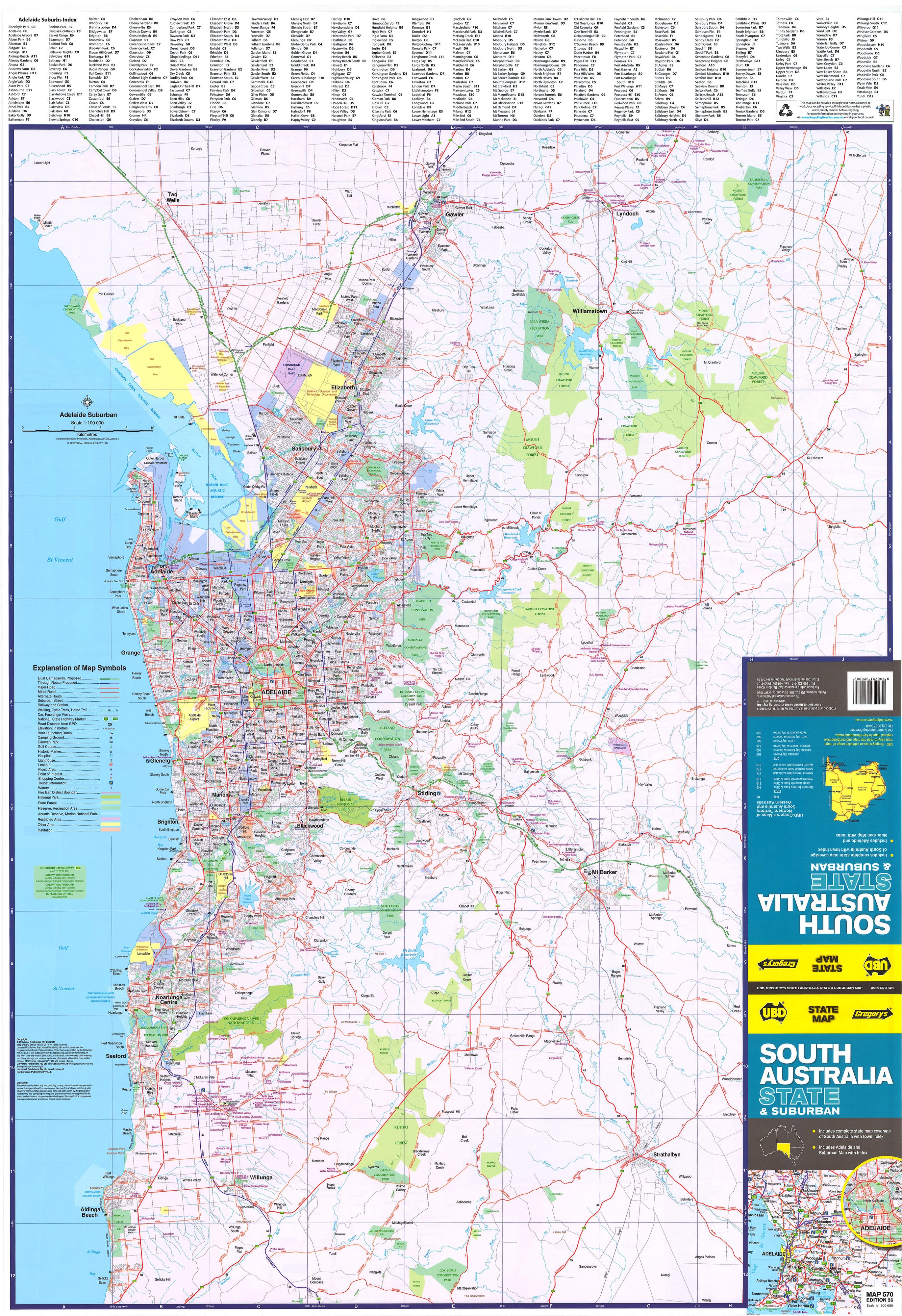
Adelaide & Region Hema 700 x 1000mm Paper Wall Map
Greater Adelaide Coverage • Postcode Boundaries • Urban Planning Utility
Scale: 1:80,000 | Size: 700 × 1000 mm
Premium matte-coated paper – perfect for framing or pinboard use
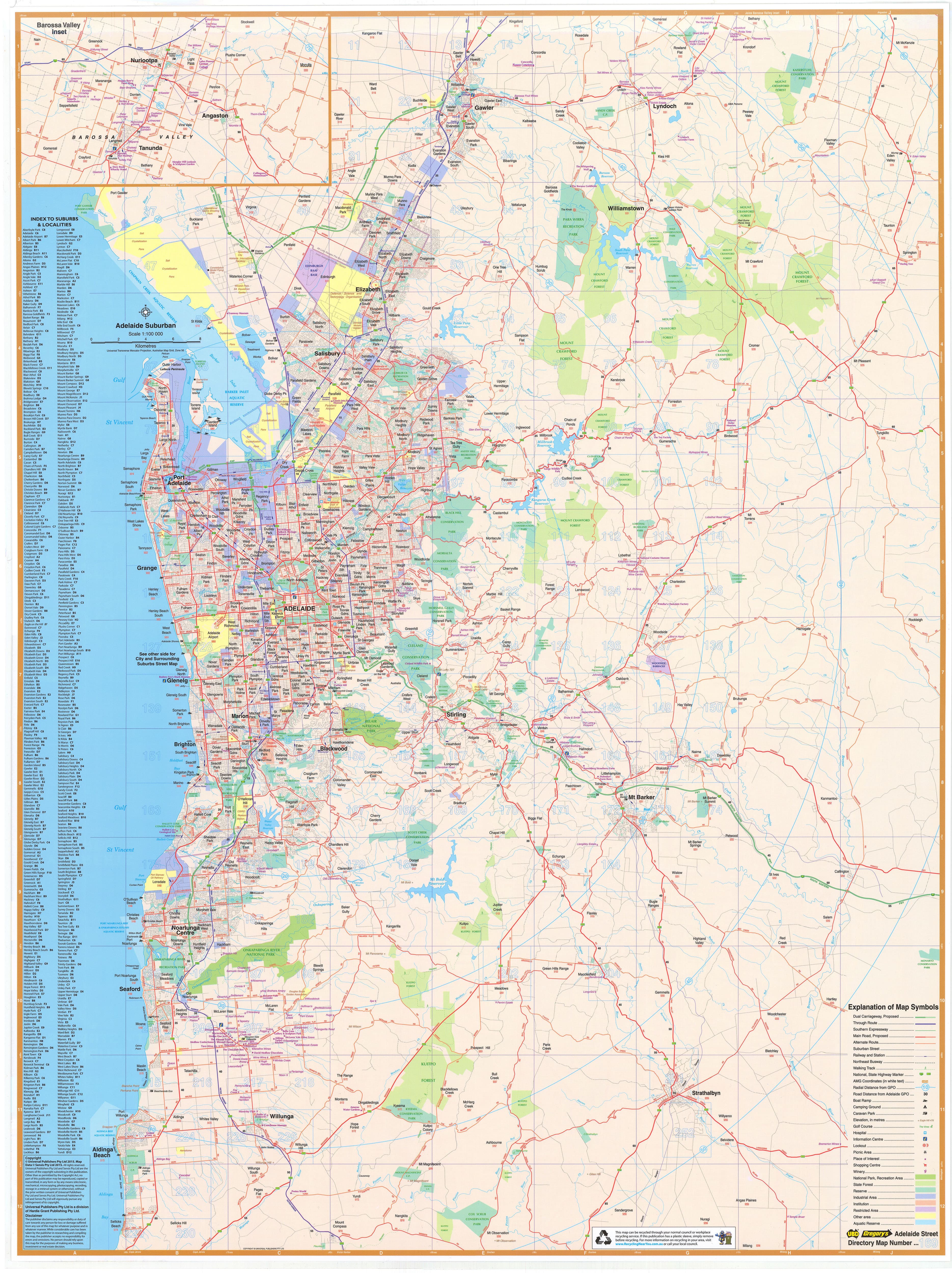
Bring clarity to your planning, business operations, or wall display with the Adelaide & Region Wall Map by trusted Australian mapmaker Hema Maps. Designed with a balance of accuracy and readability, this large-format map presents the entire Greater Adelaide region at an accessible scale — making it a smart choice for professionals, students, and geography enthusiasts alike.
🧭 Regional Coverage at a Glance
This map offers detailed coverage of Greater Adelaide, extending:
-
North to Gawler Belt
-
South to Willunga
-
East to Charleston
-
West to the coastal fringe and Gulf St Vincent
It includes the Adelaide CBD, all major suburbs, road corridors, industrial zones, and surrounding peri-urban areas — ideal for urban navigation and infrastructure planning.
🧩 Key Features & Highlights
| ✔️ Feature | 🔎 Description |
|---|---|
| 🛣️ Road Network | Clearly marked primary and secondary roads, arterial routes, and local connectors |
| 🚦 Route Numbers | Full coverage of Metropolitan, State, and National route numbers, including freeway labels |
| 🛤️ Freeway Detail | Includes existing and proposed freeways, with major upgrades already integrated |
| 🏙️ Suburban Coverage | Every suburb across the region is labelled for ease of reference |
| 🧾 Postcode Boundaries | Ideal for sales territories, franchise areas, and logistics — all postcode zones clearly marked |
| 🧭 Map Scale | 1:80,000 — strikes the perfect balance between local detail and regional overview |
| 📍 Planning-Grade Detail | Used in business, government, education, and real estate for zoning, delivery areas, and infrastructure projects |
📐 Specifications
| Property | Detail |
|---|---|
| Title | Adelaide & Region Wall Map |
| Publisher | Hema Maps |
| Scale | 1:80,000 |
| Size | 700 mm (W) × 1000 mm (H) |
| Format | Flat wall map (unfolded) |
| Paper Stock | 170 gsm matte-coated paper |
| Framing Suitability | ✔️ Ideal for framing under glass or mounting on a pinboard |
| Printing Location | Printed in Australia |
🧳 Who This Map Is For
This is not just a map — it's a practical planning tool. Perfect for:
-
🏢 Businesses: Use for sales regions, delivery zones, or service coverage
-
🚚 Logistics & Courier Companies: Plan efficient routes and highlight customer areas
-
🏫 Schools & Education: A geography reference for South Australian curriculum
-
📊 Local Government & Planning: Ideal for council offices, urban development, and infrastructure planning
-
📍 Real Estate Professionals: Great for display boards in agencies or auction houses
-
📌 Home Offices: For anyone who loves visualising their home city in detail
📦 Custom Display Options Available
Want to elevate your display? This map is also available by request in:
-
✅ Laminated Flat Wall Map – whiteboard marker-friendly
-
✅ Canvas Print with Wooden Hang Rails – premium display finish with a rustic edge
-
✅ Laminated with Timber Hang Rails – ready to hang, durable, and ideal for shared spaces
🛒 Add to Cart – Plan Greater Adelaide with Clarity & Style
Whether you're mapping your delivery runs, assigning team zones, teaching local geography, or simply looking for a reliable wall map of Adelaide, this Hema paper edition is a functional and attractive solution.
✔️ Printed on durable 170 gsm matte paper
✔️ Packed flat and rolled for safe delivery
✔️ Suitable for framing, mounting, or planning pinboards
Looking for more South Australian mapping? Pair this with:
-
Adelaide Hills & Barossa Touring Map
-
Mid North South Australia (Heysen Trail) Map
-
South Australia Handy State Map
Product Information
Product Information
Shipping & Returns
Shipping & Returns
Description
Greater Adelaide Coverage • Postcode Boundaries • Urban Planning Utility
Scale: 1:80,000 | Size: 700 × 1000 mm
Premium matte-coated paper – perfect for framing or pinboard use
Bring clarity to your planning, business operations, or wall display with the Adelaide & Region Wall Map by trusted Australian mapmaker Hema Maps. Designed with a balance of accuracy and readability, this large-format map presents the entire Greater Adelaide region at an accessible scale — making it a smart choice for professionals, students, and geography enthusiasts alike.
🧭 Regional Coverage at a Glance
This map offers detailed coverage of Greater Adelaide, extending:
-
North to Gawler Belt
-
South to Willunga
-
East to Charleston
-
West to the coastal fringe and Gulf St Vincent
It includes the Adelaide CBD, all major suburbs, road corridors, industrial zones, and surrounding peri-urban areas — ideal for urban navigation and infrastructure planning.
🧩 Key Features & Highlights
| ✔️ Feature | 🔎 Description |
|---|---|
| 🛣️ Road Network | Clearly marked primary and secondary roads, arterial routes, and local connectors |
| 🚦 Route Numbers | Full coverage of Metropolitan, State, and National route numbers, including freeway labels |
| 🛤️ Freeway Detail | Includes existing and proposed freeways, with major upgrades already integrated |
| 🏙️ Suburban Coverage | Every suburb across the region is labelled for ease of reference |
| 🧾 Postcode Boundaries | Ideal for sales territories, franchise areas, and logistics — all postcode zones clearly marked |
| 🧭 Map Scale | 1:80,000 — strikes the perfect balance between local detail and regional overview |
| 📍 Planning-Grade Detail | Used in business, government, education, and real estate for zoning, delivery areas, and infrastructure projects |
📐 Specifications
| Property | Detail |
|---|---|
| Title | Adelaide & Region Wall Map |
| Publisher | Hema Maps |
| Scale | 1:80,000 |
| Size | 700 mm (W) × 1000 mm (H) |
| Format | Flat wall map (unfolded) |
| Paper Stock | 170 gsm matte-coated paper |
| Framing Suitability | ✔️ Ideal for framing under glass or mounting on a pinboard |
| Printing Location | Printed in Australia |
🧳 Who This Map Is For
This is not just a map — it's a practical planning tool. Perfect for:
-
🏢 Businesses: Use for sales regions, delivery zones, or service coverage
-
🚚 Logistics & Courier Companies: Plan efficient routes and highlight customer areas
-
🏫 Schools & Education: A geography reference for South Australian curriculum
-
📊 Local Government & Planning: Ideal for council offices, urban development, and infrastructure planning
-
📍 Real Estate Professionals: Great for display boards in agencies or auction houses
-
📌 Home Offices: For anyone who loves visualising their home city in detail
📦 Custom Display Options Available
Want to elevate your display? This map is also available by request in:
-
✅ Laminated Flat Wall Map – whiteboard marker-friendly
-
✅ Canvas Print with Wooden Hang Rails – premium display finish with a rustic edge
-
✅ Laminated with Timber Hang Rails – ready to hang, durable, and ideal for shared spaces
🛒 Add to Cart – Plan Greater Adelaide with Clarity & Style
Whether you're mapping your delivery runs, assigning team zones, teaching local geography, or simply looking for a reliable wall map of Adelaide, this Hema paper edition is a functional and attractive solution.
✔️ Printed on durable 170 gsm matte paper
✔️ Packed flat and rolled for safe delivery
✔️ Suitable for framing, mounting, or planning pinboards
Looking for more South Australian mapping? Pair this with:
-
Adelaide Hills & Barossa Touring Map
-
Mid North South Australia (Heysen Trail) Map
-
South Australia Handy State Map