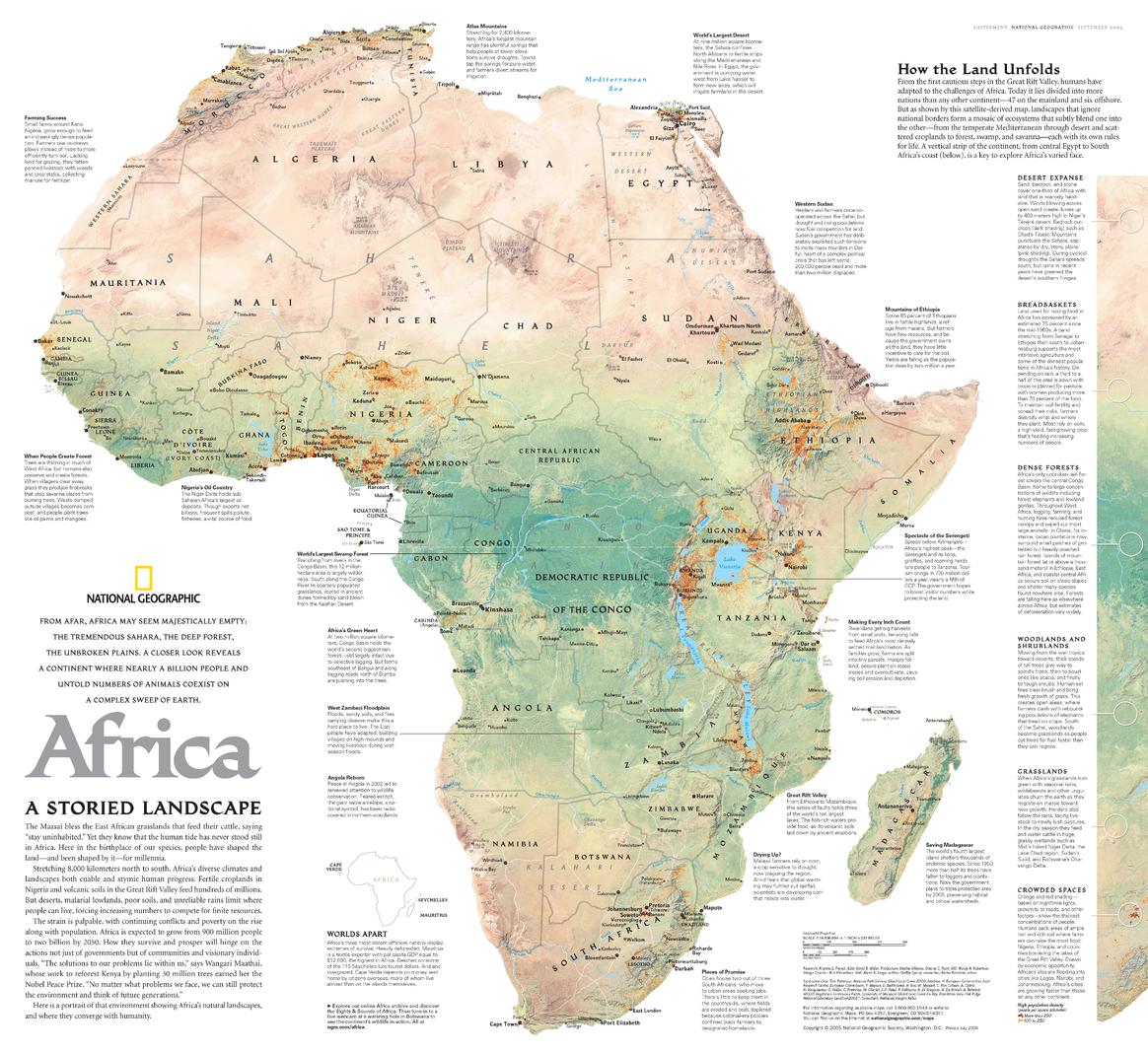
Africa, A Storied Landscape - Published 2005 by National Geographic
Africa, A Storied Landscape (2005)
Publisher: National Geographic
Published: September 2005
Scale: 1 : 14,636,000
Size: 616 mm (W) × 565 mm (H)
Orientation: Landscape
Map Type: Historical & Scientific Thematic Map
Africa, A Storied Landscape presents the African continent through the lens of deep time, ecology, and human adaptation. From humanity’s earliest steps in the Great Rift Valley to the complex environmental patterns that shape the continent today, this satellite-derived map reveals Africa not as a patchwork of political borders, but as a living mosaic of landscapes.
Published in 2005, the map highlights how Africa’s environments — from the Mediterranean fringe through deserts and croplands, and onward to forests, wetlands, and savannas — blend gradually into one another, each governed by its own ecological rules. These natural systems transcend national boundaries, offering a powerful counterpoint to modern political divisions.
This map forms one half of a two-map set, paired with Africa: The Human Footprint, which explores how people have shaped and altered these landscapes over time.
🌍 What This Map Shows
-
Satellite-derived depiction of Africa’s major landscapes
-
A continent-wide mosaic of ecosystems, not political states
-
Gradual transitions between climate zones and land types
-
Context for understanding human evolution, settlement, and adaptation
-
Natural regions that cut across modern national borders
The emphasis is on landscape continuity, revealing Africa as an interconnected environmental system.
🕰️ Africa Through Deep Time
-
Highlights the Great Rift Valley, cradle of early human evolution
-
Illustrates how geography shaped migration, survival, and culture
-
Shows Africa as the most ecologically diverse continent
-
Encourages thinking beyond borders toward long-term environmental patterns
This is a map that connects history, science, and geography in a single, compelling visual narrative.
🎨 Cartography & Scientific Storytelling
-
Derived from satellite imagery for accuracy and realism
-
Subtle colour gradients convey ecological transitions
-
Minimal political distraction keeps focus on land and life
-
A hallmark of National Geographic’s science-forward thematic cartography
The result is a map that is as intellectually engaging as it is visually striking.
🎨 Materials, Print Quality & Hanging Options
📄 Paper (Classic Framing Option)
-
Printed on high-quality matte paper for crisp detail and accurate colour
-
Smooth, low-glare surface — ideal for framing under glass
-
A refined option for studies, libraries, and educational spaces
🔒 Laminated (Write-On / Wipe-Off)
-
Printed on quality paper and encapsulated in protective laminate
-
Durable, waterproof, and tear-resistant
-
Write-on / wipe-off surface compatible with whiteboard markers and map dots
-
Ideal for classrooms, teaching, and interactive discussion
🪵 Optional Timber Hang Rails — Laminated
-
Top and bottom natural timber rails provide structure and balance
-
Bottom rail adds weight so the map hangs flat and straight
-
Prevents edge curl and long-term sagging
-
Supplied with hanging cord — ready to mount on a single hook
Please allow up to 10 working days for laminated maps with hang rails.
🎨 Archival Canvas (Premium Display Option)
-
Printed on 395 gsm HP Professional Matte Canvas
-
Subtle canvas texture enhances depth while preserving fine detail
-
Matte surface reduces reflections compared with glass-framed prints
Archival Pigment Inks
-
Produced using Hewlett-Packard archival, fade-resistant pigment inks
-
Ensures stable colour, sharp detail, and long-term durability
🪵 Optional Timber Hang Rails — Canvas
-
Top and bottom timber rails create a clean, gallery-style presentation
-
Bottom rail adds weight for a perfectly straight hang
-
Prevents edge curl and sag over time
-
Supplied with hanging cord — ready to mount
Please allow up to 10 working days for canvas maps with hang rails.
Canvas editions are intended for display and reference and are not write-on / wipe-off like laminated versions.
📐 Size & Scale
-
Size: 616 mm × 565 mm
-
Scale: 1 : 14,636,000
A balanced wall size that suits classrooms, libraries, offices, and thoughtful home displays.
📊 Specifications
| Attribute | Details |
|---|---|
| Title | Africa, A Storied Landscape |
| Publisher | National Geographic |
| Year | 2005 |
| Coverage | Africa |
| Map Type | Historical & scientific thematic map |
| Focus | Ecosystems, landscapes, environmental continuity |
| Companion Map | Africa: The Human Footprint |
| Scale | 1 : 14,636,000 |
| Available Formats | Paper • Laminated • Laminated + Hang Rails • Canvas • Canvas + Hang Rails |
| Canvas Weight | 395 gsm HP Professional Matte |
| Inks (Canvas) | Hewlett-Packard archival, fade-resistant pigment inks |
| Size | 616 mm × 565 mm |
| Orientation | Landscape |
| Tags | Continents • History & Science |
🎯 Who It’s For
-
🌍 Educators & students — geography, ecology, and human evolution
-
🧪 Science-focused libraries & institutions
-
🗺️ National Geographic collectors — standout thematic cartography
-
🏠 Homes & studies — intellectually rich wall art
-
🎁 Gift buyers — thoughtful and conversation-starting
🤝 Our Commitment
This National Geographic map is reproduced and printed in Australia with careful attention to colour, clarity, and finish. Each copy is checked and packed with care, ensuring it arrives ready to inform, inspire, and endure.
🛒 See Africa beyond borders — choose Paper, Laminated, or Canvas, with optional timber hang rails, and order Africa, A Storied Landscape (2005) today.
Product Information
Product Information
Shipping & Returns
Shipping & Returns
Description
Africa, A Storied Landscape (2005)
Publisher: National Geographic
Published: September 2005
Scale: 1 : 14,636,000
Size: 616 mm (W) × 565 mm (H)
Orientation: Landscape
Map Type: Historical & Scientific Thematic Map
Africa, A Storied Landscape presents the African continent through the lens of deep time, ecology, and human adaptation. From humanity’s earliest steps in the Great Rift Valley to the complex environmental patterns that shape the continent today, this satellite-derived map reveals Africa not as a patchwork of political borders, but as a living mosaic of landscapes.
Published in 2005, the map highlights how Africa’s environments — from the Mediterranean fringe through deserts and croplands, and onward to forests, wetlands, and savannas — blend gradually into one another, each governed by its own ecological rules. These natural systems transcend national boundaries, offering a powerful counterpoint to modern political divisions.
This map forms one half of a two-map set, paired with Africa: The Human Footprint, which explores how people have shaped and altered these landscapes over time.
🌍 What This Map Shows
-
Satellite-derived depiction of Africa’s major landscapes
-
A continent-wide mosaic of ecosystems, not political states
-
Gradual transitions between climate zones and land types
-
Context for understanding human evolution, settlement, and adaptation
-
Natural regions that cut across modern national borders
The emphasis is on landscape continuity, revealing Africa as an interconnected environmental system.
🕰️ Africa Through Deep Time
-
Highlights the Great Rift Valley, cradle of early human evolution
-
Illustrates how geography shaped migration, survival, and culture
-
Shows Africa as the most ecologically diverse continent
-
Encourages thinking beyond borders toward long-term environmental patterns
This is a map that connects history, science, and geography in a single, compelling visual narrative.
🎨 Cartography & Scientific Storytelling
-
Derived from satellite imagery for accuracy and realism
-
Subtle colour gradients convey ecological transitions
-
Minimal political distraction keeps focus on land and life
-
A hallmark of National Geographic’s science-forward thematic cartography
The result is a map that is as intellectually engaging as it is visually striking.
🎨 Materials, Print Quality & Hanging Options
📄 Paper (Classic Framing Option)
-
Printed on high-quality matte paper for crisp detail and accurate colour
-
Smooth, low-glare surface — ideal for framing under glass
-
A refined option for studies, libraries, and educational spaces
🔒 Laminated (Write-On / Wipe-Off)
-
Printed on quality paper and encapsulated in protective laminate
-
Durable, waterproof, and tear-resistant
-
Write-on / wipe-off surface compatible with whiteboard markers and map dots
-
Ideal for classrooms, teaching, and interactive discussion
🪵 Optional Timber Hang Rails — Laminated
-
Top and bottom natural timber rails provide structure and balance
-
Bottom rail adds weight so the map hangs flat and straight
-
Prevents edge curl and long-term sagging
-
Supplied with hanging cord — ready to mount on a single hook
Please allow up to 10 working days for laminated maps with hang rails.
🎨 Archival Canvas (Premium Display Option)
-
Printed on 395 gsm HP Professional Matte Canvas
-
Subtle canvas texture enhances depth while preserving fine detail
-
Matte surface reduces reflections compared with glass-framed prints
Archival Pigment Inks
-
Produced using Hewlett-Packard archival, fade-resistant pigment inks
-
Ensures stable colour, sharp detail, and long-term durability
🪵 Optional Timber Hang Rails — Canvas
-
Top and bottom timber rails create a clean, gallery-style presentation
-
Bottom rail adds weight for a perfectly straight hang
-
Prevents edge curl and sag over time
-
Supplied with hanging cord — ready to mount
Please allow up to 10 working days for canvas maps with hang rails.
Canvas editions are intended for display and reference and are not write-on / wipe-off like laminated versions.
📐 Size & Scale
-
Size: 616 mm × 565 mm
-
Scale: 1 : 14,636,000
A balanced wall size that suits classrooms, libraries, offices, and thoughtful home displays.
📊 Specifications
| Attribute | Details |
|---|---|
| Title | Africa, A Storied Landscape |
| Publisher | National Geographic |
| Year | 2005 |
| Coverage | Africa |
| Map Type | Historical & scientific thematic map |
| Focus | Ecosystems, landscapes, environmental continuity |
| Companion Map | Africa: The Human Footprint |
| Scale | 1 : 14,636,000 |
| Available Formats | Paper • Laminated • Laminated + Hang Rails • Canvas • Canvas + Hang Rails |
| Canvas Weight | 395 gsm HP Professional Matte |
| Inks (Canvas) | Hewlett-Packard archival, fade-resistant pigment inks |
| Size | 616 mm × 565 mm |
| Orientation | Landscape |
| Tags | Continents • History & Science |
🎯 Who It’s For
-
🌍 Educators & students — geography, ecology, and human evolution
-
🧪 Science-focused libraries & institutions
-
🗺️ National Geographic collectors — standout thematic cartography
-
🏠 Homes & studies — intellectually rich wall art
-
🎁 Gift buyers — thoughtful and conversation-starting
🤝 Our Commitment
This National Geographic map is reproduced and printed in Australia with careful attention to colour, clarity, and finish. Each copy is checked and packed with care, ensuring it arrives ready to inform, inspire, and endure.
🛒 See Africa beyond borders — choose Paper, Laminated, or Canvas, with optional timber hang rails, and order Africa, A Storied Landscape (2005) today.


