Africa Political & Physical Continent Map
Dual-View Reference | Political & Topographic Detail | Large Wall Format (1000 × 627 mm)
A beautifully balanced, large-format map that brings Africa into clear focus from two essential perspectives—political structure and physical landscape—presented in one cohesive, easy-to-read design.
Published by Globe Turner, this map transforms the vast complexity of Africa into a format that is both intuitive and visually engaging. From national borders and major cities to elevation, terrain, and landforms, it offers a complete continental overview at a glance.
At this expanded wall size, every detail is given room to breathe—making it ideal for education, planning, and display.
Why This Map Stands Out
Two complementary views in one
Combines a detailed political map with a richly coloured physical map—delivering both structure and landscape in a single sheet.
Clarity at larger scale
Now presented at 1000 mm wide, the map offers improved readability and stronger wall presence.
Topography made visual
Colour and relief shading highlight Africa’s diverse terrain—from highlands to deserts and river basins.
Educational depth built in
Includes a fact panel and elevation profile—ideal for teaching and quick reference.
A versatile wall map
Equally suited to classrooms, offices, and home study environments.
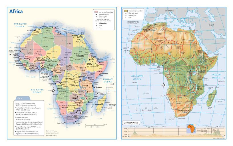
🗺️ What the Map Shows
- A full political view of Africa with countries, capitals, and major cities clearly labelled
- A detailed physical map showing:
- Mountain ranges such as the Atlas and Ethiopian Highlands
- Deserts including the Sahara, Namib, and Kalahari
- Major rivers like the Nile, Congo, and Niger
- Lakes and basins across the continent
- A cross-continent elevation profile, illustrating terrain changes from coast to interior
- A reference panel with key facts and insights about Africa
This dual presentation allows you to understand both how Africa is organised—and how it is formed.
📐 Size & Format
1000 mm (W) × 627 mm (H)
Landscape orientation
A substantial wall format that enhances both legibility and visual impact, ideal for:
- Classrooms and lecture spaces
- Offices and meeting rooms
- Home studies and libraries
- Educational displays and reference walls
✨ Premium Finishes
| Format | Description |
|---|---|
| 📜 Paper (160 gsm) | Heavyweight matte-coated paper—ideal for framing. Crisp detail with a refined, low-glare finish. |
| 🧼 Laminated (Encapsulated) | Sealed in 2 × 80-micron gloss laminate. Durable, wipe-clean, and perfect for annotation. |
| 🪵 Laminated + Timber Hang Rails | Laminated map mounted with lacquered natural timber rails and hanging cord—ready to display. |
| 🖼️ Canvas (395 gsm HP Professional Matte) | Printed with archival pigment inks. Rich texture and gallery-quality presentation. |
| 🪵 Canvas + Timber Hang Rails | Canvas paired with timber rails for a refined, frame-free display solution. |
🔨 Please allow up to 10 working days for professionally mounted hang-railed finishes.
📊 Specifications
| Feature | Detail |
|---|---|
| Title | Africa — Political & Physical Continent Map |
| Publisher | Globe Turner |
| Published | 2019 |
| Dimensions | 1000 mm × 627 mm |
| Orientation | Landscape |
| Map Type | Political & Physical (Dual Map) |
| Features | Countries, cities, terrain, elevation profile, fact panel |
| Materials | 160 gsm matte paper / 2 × 80-micron laminate / 395 gsm HP Professional Matte Canvas |
| Printing | Pigment-based, fade-resistant inks |
| Origin | Printed in Australia |
🎯 Ideal For
- Educators and students needing a clear continental overview
- Classrooms and learning environments
- Offices requiring a large, readable Africa reference map
- Travellers and geography enthusiasts
- Gift buyers seeking an educational yet decorative map
🌍 Two Perspectives, One Continent
This map’s strength lies in its dual perspective:
- The political map explains borders, nations, and cities
- The physical map reveals terrain, elevation, and natural systems
Together, they provide a deeper understanding of Africa—showing how landforms shape cultures, economies, and movement.
🤝 Our Commitment
- Printed in Australia using archival-quality processes
- Premium materials selected for clarity and durability
- Colour-managed for consistent readability at scale
- Each map is hand-checked before dispatch
- Carefully packed for safe delivery
🚚 Delivery
- Paper, Laminated, Canvas (rolled): Dispatch within 1–2 business days
- Hang-Railed Maps: Made to order—allow up to 10 working days
- Packaging: Securely rolled in protective tubing
A continent brought into focus—clear, structured, and visually compelling.
👉 Order now and explore Africa from both a political and physical perspective.
Original: $57.20
-65%$57.20
$20.02Product Information
Product Information
Shipping & Returns
Shipping & Returns
Description
Dual-View Reference | Political & Topographic Detail | Large Wall Format (1000 × 627 mm)
A beautifully balanced, large-format map that brings Africa into clear focus from two essential perspectives—political structure and physical landscape—presented in one cohesive, easy-to-read design.
Published by Globe Turner, this map transforms the vast complexity of Africa into a format that is both intuitive and visually engaging. From national borders and major cities to elevation, terrain, and landforms, it offers a complete continental overview at a glance.
At this expanded wall size, every detail is given room to breathe—making it ideal for education, planning, and display.
Why This Map Stands Out
Two complementary views in one
Combines a detailed political map with a richly coloured physical map—delivering both structure and landscape in a single sheet.
Clarity at larger scale
Now presented at 1000 mm wide, the map offers improved readability and stronger wall presence.
Topography made visual
Colour and relief shading highlight Africa’s diverse terrain—from highlands to deserts and river basins.
Educational depth built in
Includes a fact panel and elevation profile—ideal for teaching and quick reference.
A versatile wall map
Equally suited to classrooms, offices, and home study environments.
🗺️ What the Map Shows
- A full political view of Africa with countries, capitals, and major cities clearly labelled
- A detailed physical map showing:
- Mountain ranges such as the Atlas and Ethiopian Highlands
- Deserts including the Sahara, Namib, and Kalahari
- Major rivers like the Nile, Congo, and Niger
- Lakes and basins across the continent
- A cross-continent elevation profile, illustrating terrain changes from coast to interior
- A reference panel with key facts and insights about Africa
This dual presentation allows you to understand both how Africa is organised—and how it is formed.
📐 Size & Format
1000 mm (W) × 627 mm (H)
Landscape orientation
A substantial wall format that enhances both legibility and visual impact, ideal for:
- Classrooms and lecture spaces
- Offices and meeting rooms
- Home studies and libraries
- Educational displays and reference walls
✨ Premium Finishes
| Format | Description |
|---|---|
| 📜 Paper (160 gsm) | Heavyweight matte-coated paper—ideal for framing. Crisp detail with a refined, low-glare finish. |
| 🧼 Laminated (Encapsulated) | Sealed in 2 × 80-micron gloss laminate. Durable, wipe-clean, and perfect for annotation. |
| 🪵 Laminated + Timber Hang Rails | Laminated map mounted with lacquered natural timber rails and hanging cord—ready to display. |
| 🖼️ Canvas (395 gsm HP Professional Matte) | Printed with archival pigment inks. Rich texture and gallery-quality presentation. |
| 🪵 Canvas + Timber Hang Rails | Canvas paired with timber rails for a refined, frame-free display solution. |
🔨 Please allow up to 10 working days for professionally mounted hang-railed finishes.
📊 Specifications
| Feature | Detail |
|---|---|
| Title | Africa — Political & Physical Continent Map |
| Publisher | Globe Turner |
| Published | 2019 |
| Dimensions | 1000 mm × 627 mm |
| Orientation | Landscape |
| Map Type | Political & Physical (Dual Map) |
| Features | Countries, cities, terrain, elevation profile, fact panel |
| Materials | 160 gsm matte paper / 2 × 80-micron laminate / 395 gsm HP Professional Matte Canvas |
| Printing | Pigment-based, fade-resistant inks |
| Origin | Printed in Australia |
🎯 Ideal For
- Educators and students needing a clear continental overview
- Classrooms and learning environments
- Offices requiring a large, readable Africa reference map
- Travellers and geography enthusiasts
- Gift buyers seeking an educational yet decorative map
🌍 Two Perspectives, One Continent
This map’s strength lies in its dual perspective:
- The political map explains borders, nations, and cities
- The physical map reveals terrain, elevation, and natural systems
Together, they provide a deeper understanding of Africa—showing how landforms shape cultures, economies, and movement.
🤝 Our Commitment
- Printed in Australia using archival-quality processes
- Premium materials selected for clarity and durability
- Colour-managed for consistent readability at scale
- Each map is hand-checked before dispatch
- Carefully packed for safe delivery
🚚 Delivery
- Paper, Laminated, Canvas (rolled): Dispatch within 1–2 business days
- Hang-Railed Maps: Made to order—allow up to 10 working days
- Packaging: Securely rolled in protective tubing
A continent brought into focus—clear, structured, and visually compelling.
👉 Order now and explore Africa from both a political and physical perspective.


