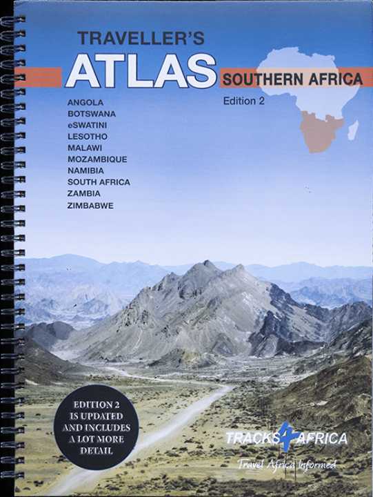
Africa Southern Travellers Atlas - Traks4Africa
Africa Southern Traveller’s Atlas — Tracks4Africa
A3 Hard-Cover | Spiral Bound | Multi-Scale Overland Mapping | 10 Countries
🌍 Angola • Botswana • Lesotho • Malawi • Mozambique • Namibia • South Africa • Eswatini • Zambia • Zimbabwe
If you are planning a serious self-drive journey through Southern Africa, this is the atlas built for it.
The Africa Southern Traveller’s Atlas is not a lightweight tourist book — it is a substantial, field-ready navigation reference designed specifically for overlanders. Weighing approximately 2.75 kg, printed in large A3 format, spiral bound and finished with a hard laminated cover, it is built to lie flat on a table, dashboard or camp bench while you plan the next stage of your journey.
This second edition is significantly expanded — thicker, more detailed, and more comprehensive than the first.
🗺️ Multi-Scale Mapping — From Continental Strategy to Local Detail
One of the greatest strengths of this atlas is its layered scale system:
🌍 1 : 4,000,000 — Southern & Eastern Africa Overview
Perfect for macro planning.
Visualise cross-border routes, regional corridors and multi-country expeditions at a glance.
🧭 1 : 1,000,000 — National Coverage
Detailed mapping for all ten countries included:
-
Angola
-
Botswana
-
Lesotho
-
Malawi
-
Mozambique
-
Namibia
-
South Africa
-
Eswatini
-
Zambia
-
Zimbabwe
These pages allow country-wide route comparison and long-distance stage planning.
🚙 1 : 500,000 — High-Detail Mapping
Included for:
-
South Africa
-
Malawi
-
Much of Zambia
-
Moremi / Chobe region in Botswana
These pages are ideal for navigating wildlife reserves, remote gravel corridors and complex regional networks.
🛣️ Built from Real Overland Data
This atlas is compiled from the same trusted data used in Tracks4Africa GPS maps.
It includes:
-
Over 518,000 km of major roads and off-road tracks
-
Distances and travel times between towns (on 1:1M and 1:500K maps)
-
Travel-time tables for major routes per country
-
Comprehensive national and park road coverage
You can plan your days realistically — whether travelling on tar, gravel or sand.
And if you’re using a Tracks4Africa GPS, the data aligns seamlessly between paper and digital.
🧭 Essential Cross-Border & Vehicle Information
Southern Africa is a region of borders, paperwork and practical considerations. This atlas includes:
✔️ Legal vehicle requirements per country
✔️ Traffic rules and local driving conditions
✔️ Road condition guidance
✔️ Fuel availability insights
✔️ Cross-border procedures
✔️ 127 border posts listed with opening times
For long expeditions, this kind of preparation is invaluable.
🏕️ On-the-Road Intelligence
The atlas is packed with practical travel detail:
⛽ Fuel stations
🏧 Banks & ATMs
🛒 Shopping facilities
🏥 Hospitals
🔧 Auto repair services
🏕️ Camping & lodging
🌿 Protected areas
⭐ Major and minor tourist attractions
✈️ International airports (with IATA/ICAO codes)
Each town page shows which services are available — making logistical planning straightforward.
📘 Physical Construction — Built for the Journey
📄 A3 page size — large and highly legible
📚 223 map pages — substantial, detailed coverage
💪 Thicker-than-normal paper stock — durable for field use
🔒 Hard laminated cover — robust protection
🌀 Spiral binding — lies flat for easy consultation
This is an atlas you can actually use on the road — not one that closes itself mid-route.
🎯 Who This Atlas Is For
🚙 Overlanders planning multi-country expeditions
🌍 Self-drive travellers exploring Southern Africa
🏕️ Safari enthusiasts mapping park-to-park routes
📍 Long-distance tour planners
🧭 Travellers who want a comprehensive offline reference
If you are travelling beyond one country — this atlas becomes your command centre.
📦 Ordering Information
This is an Order-on-Demand Atlas.
🕒 Please allow up to 10 working days for delivery.
⭐ The Strategic Planning Tool for Southern Africa
Southern Africa rewards preparation. Distances are vast. Borders are numerous. Road surfaces vary dramatically.
The Africa Southern Traveller’s Atlas gives you:
✔️ Big-picture regional clarity
✔️ National and high-detail mapping
✔️ Realistic travel-time data
✔️ Cross-border intelligence
✔️ Durable construction for expedition conditions
It is not just an atlas — it is the foundation for a serious overland journey.
Open it. Compare routes. Mark your stages.
And set out across Southern Africa with confidence.
Original: $135.90
-65%$135.90
$47.56Product Information
Product Information
Shipping & Returns
Shipping & Returns
Description
Africa Southern Traveller’s Atlas — Tracks4Africa
A3 Hard-Cover | Spiral Bound | Multi-Scale Overland Mapping | 10 Countries
🌍 Angola • Botswana • Lesotho • Malawi • Mozambique • Namibia • South Africa • Eswatini • Zambia • Zimbabwe
If you are planning a serious self-drive journey through Southern Africa, this is the atlas built for it.
The Africa Southern Traveller’s Atlas is not a lightweight tourist book — it is a substantial, field-ready navigation reference designed specifically for overlanders. Weighing approximately 2.75 kg, printed in large A3 format, spiral bound and finished with a hard laminated cover, it is built to lie flat on a table, dashboard or camp bench while you plan the next stage of your journey.
This second edition is significantly expanded — thicker, more detailed, and more comprehensive than the first.
🗺️ Multi-Scale Mapping — From Continental Strategy to Local Detail
One of the greatest strengths of this atlas is its layered scale system:
🌍 1 : 4,000,000 — Southern & Eastern Africa Overview
Perfect for macro planning.
Visualise cross-border routes, regional corridors and multi-country expeditions at a glance.
🧭 1 : 1,000,000 — National Coverage
Detailed mapping for all ten countries included:
-
Angola
-
Botswana
-
Lesotho
-
Malawi
-
Mozambique
-
Namibia
-
South Africa
-
Eswatini
-
Zambia
-
Zimbabwe
These pages allow country-wide route comparison and long-distance stage planning.
🚙 1 : 500,000 — High-Detail Mapping
Included for:
-
South Africa
-
Malawi
-
Much of Zambia
-
Moremi / Chobe region in Botswana
These pages are ideal for navigating wildlife reserves, remote gravel corridors and complex regional networks.
🛣️ Built from Real Overland Data
This atlas is compiled from the same trusted data used in Tracks4Africa GPS maps.
It includes:
-
Over 518,000 km of major roads and off-road tracks
-
Distances and travel times between towns (on 1:1M and 1:500K maps)
-
Travel-time tables for major routes per country
-
Comprehensive national and park road coverage
You can plan your days realistically — whether travelling on tar, gravel or sand.
And if you’re using a Tracks4Africa GPS, the data aligns seamlessly between paper and digital.
🧭 Essential Cross-Border & Vehicle Information
Southern Africa is a region of borders, paperwork and practical considerations. This atlas includes:
✔️ Legal vehicle requirements per country
✔️ Traffic rules and local driving conditions
✔️ Road condition guidance
✔️ Fuel availability insights
✔️ Cross-border procedures
✔️ 127 border posts listed with opening times
For long expeditions, this kind of preparation is invaluable.
🏕️ On-the-Road Intelligence
The atlas is packed with practical travel detail:
⛽ Fuel stations
🏧 Banks & ATMs
🛒 Shopping facilities
🏥 Hospitals
🔧 Auto repair services
🏕️ Camping & lodging
🌿 Protected areas
⭐ Major and minor tourist attractions
✈️ International airports (with IATA/ICAO codes)
Each town page shows which services are available — making logistical planning straightforward.
📘 Physical Construction — Built for the Journey
📄 A3 page size — large and highly legible
📚 223 map pages — substantial, detailed coverage
💪 Thicker-than-normal paper stock — durable for field use
🔒 Hard laminated cover — robust protection
🌀 Spiral binding — lies flat for easy consultation
This is an atlas you can actually use on the road — not one that closes itself mid-route.
🎯 Who This Atlas Is For
🚙 Overlanders planning multi-country expeditions
🌍 Self-drive travellers exploring Southern Africa
🏕️ Safari enthusiasts mapping park-to-park routes
📍 Long-distance tour planners
🧭 Travellers who want a comprehensive offline reference
If you are travelling beyond one country — this atlas becomes your command centre.
📦 Ordering Information
This is an Order-on-Demand Atlas.
🕒 Please allow up to 10 working days for delivery.
⭐ The Strategic Planning Tool for Southern Africa
Southern Africa rewards preparation. Distances are vast. Borders are numerous. Road surfaces vary dramatically.
The Africa Southern Traveller’s Atlas gives you:
✔️ Big-picture regional clarity
✔️ National and high-detail mapping
✔️ Realistic travel-time data
✔️ Cross-border intelligence
✔️ Durable construction for expedition conditions
It is not just an atlas — it is the foundation for a serious overland journey.
Open it. Compare routes. Mark your stages.
And set out across Southern Africa with confidence.