Africa Threatened - Published 1990 by National Geographic
Environmental & Wildlife Map | Conservation, Habitat & Species at Risk | Large Wall Format (726 × 560 mm) | Premium Finishes
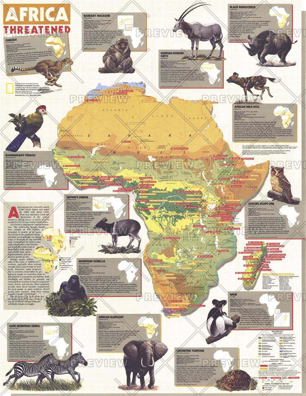
A powerful and sobering look at the pressures facing one of the world’s most biodiverse continents, Africa Threatened reveals the scale of environmental change and its impact on wildlife. Published by National Geographic in December 1990, this map was created as a companion to the Africa map and a series of feature articles including “A Gathering of Waters and Wildlife.”
At its heart lies a stark reality: Africa’s ecosystems—once vast and abundant—are increasingly under threat. The dramatic decline of the black rhinoceros, from tens of thousands in the 1970s to only a few thousand by the late 1980s, stands as one of the most striking examples of the challenges explored in this map.
Why This Map Stands Out
A critical conservation perspective
Highlights the growing threats to Africa’s wildlife and ecosystems.
Data-driven and visually engaging
Combines geographic mapping with environmental and species information.
Focus on real-world impact
Illustrates population decline, habitat loss, and human pressures.
National Geographic authority
Balances scientific accuracy with clear, compelling design.
A meaningful and thought-provoking display
Ideal for those interested in conservation, ecology, and global change.
🗺️ What the Map Shows
- Distribution of wildlife species across Africa
- Regions experiencing habitat loss and environmental stress
- Key conservation areas and ecological zones
- Pressures from human activity, land use, and resource demand
- Case studies such as the decline of the Black Rhinoceros
- A broader view of how ecosystems are being altered across the continent
📐 Size & Format
726 mm (H) × 560 mm (W)
Portrait orientation
A strong, display-ready format ideal for:
- Classrooms and environmental studies
- Offices and conservation organisations
- Home studies and educational spaces
- Interiors focused on nature and global awareness
✨ Premium Finishes
| Format | Description |
|---|---|
| 📜 Paper (160 gsm) | Heavyweight matte-coated paper—ideal for framing. Preserves clarity and colour detail. |
| 🧼 Laminated (Encapsulated) | Sealed in 2 × 80-micron gloss laminate. Durable, wipe-clean, and suitable for regular reference. |
| 🪵 Laminated + Timber Hang Rails | Laminated map mounted with lacquered natural timber rails and hanging cord—ready to display. |
| 🖼️ Canvas (395 gsm HP Professional Matte) | Printed with archival pigment inks. Rich texture enhances depth and visual presence. |
| 🪵 Canvas + Timber Hang Rails | Canvas paired with timber rails for a refined, gallery-style presentation. |
🔨 Please allow up to 10 working days for professionally mounted hang-railed finishes.
📊 Specifications
| Feature | Detail |
|---|---|
| Title | Africa Threatened |
| Publisher | National Geographic |
| Published | 1990 |
| Dimensions | 726 mm × 560 mm |
| Orientation | Landscape |
| Map Type | Thematic / Environmental |
| Focus | Wildlife, conservation, habitat pressure |
| Collections | Africa, Historical |
| Materials | 160 gsm matte paper / 2 × 80-micron laminate / 395 gsm HP Professional Matte Canvas |
| Printing | Pigment-based, fade-resistant inks |
| Origin | Printed in Australia |
🎯 Ideal For
- Students and educators of environmental science and ecology
- Conservationists and wildlife enthusiasts
- Organisations focused on sustainability and biodiversity
- Interiors seeking a meaningful, conversation-starting piece
- Gift buyers looking for a thoughtful and impactful map
🐘 A Continent at a Crossroads
Africa’s landscapes are rich—but increasingly fragile:
- Wildlife populations under pressure from human expansion
- Habitats shrinking and ecosystems shifting
- Conservation efforts striving to protect what remains
- A delicate balance between development and preservation
This map captures that moment—revealing both the beauty of Africa’s natural world and the urgency of protecting it.
🤝 Our Commitment
- Printed in Australia using archival-quality production
- Faithfully reproduced to preserve clarity and detail
- Premium materials selected for durability and longevity
- Each map is hand-checked before dispatch
- Carefully packaged for safe delivery
🚚 Delivery
- Paper, Laminated, Canvas (rolled): Dispatch within 1–2 business days
- Hang-Railed Maps: Made to order—allow up to 10 working days
- Packaging: Securely rolled in protective tubing
See Africa through the lens of conservation—
a map that brings wildlife, risk, and responsibility into focus.
👉 Order now and add a powerful environmental statement to your wall.
Original: $57.20
-65%$57.20
$20.02Product Information
Product Information
Shipping & Returns
Shipping & Returns
Description
Environmental & Wildlife Map | Conservation, Habitat & Species at Risk | Large Wall Format (726 × 560 mm) | Premium Finishes
A powerful and sobering look at the pressures facing one of the world’s most biodiverse continents, Africa Threatened reveals the scale of environmental change and its impact on wildlife. Published by National Geographic in December 1990, this map was created as a companion to the Africa map and a series of feature articles including “A Gathering of Waters and Wildlife.”
At its heart lies a stark reality: Africa’s ecosystems—once vast and abundant—are increasingly under threat. The dramatic decline of the black rhinoceros, from tens of thousands in the 1970s to only a few thousand by the late 1980s, stands as one of the most striking examples of the challenges explored in this map.
Why This Map Stands Out
A critical conservation perspective
Highlights the growing threats to Africa’s wildlife and ecosystems.
Data-driven and visually engaging
Combines geographic mapping with environmental and species information.
Focus on real-world impact
Illustrates population decline, habitat loss, and human pressures.
National Geographic authority
Balances scientific accuracy with clear, compelling design.
A meaningful and thought-provoking display
Ideal for those interested in conservation, ecology, and global change.
🗺️ What the Map Shows
- Distribution of wildlife species across Africa
- Regions experiencing habitat loss and environmental stress
- Key conservation areas and ecological zones
- Pressures from human activity, land use, and resource demand
- Case studies such as the decline of the Black Rhinoceros
- A broader view of how ecosystems are being altered across the continent
📐 Size & Format
726 mm (H) × 560 mm (W)
Portrait orientation
A strong, display-ready format ideal for:
- Classrooms and environmental studies
- Offices and conservation organisations
- Home studies and educational spaces
- Interiors focused on nature and global awareness
✨ Premium Finishes
| Format | Description |
|---|---|
| 📜 Paper (160 gsm) | Heavyweight matte-coated paper—ideal for framing. Preserves clarity and colour detail. |
| 🧼 Laminated (Encapsulated) | Sealed in 2 × 80-micron gloss laminate. Durable, wipe-clean, and suitable for regular reference. |
| 🪵 Laminated + Timber Hang Rails | Laminated map mounted with lacquered natural timber rails and hanging cord—ready to display. |
| 🖼️ Canvas (395 gsm HP Professional Matte) | Printed with archival pigment inks. Rich texture enhances depth and visual presence. |
| 🪵 Canvas + Timber Hang Rails | Canvas paired with timber rails for a refined, gallery-style presentation. |
🔨 Please allow up to 10 working days for professionally mounted hang-railed finishes.
📊 Specifications
| Feature | Detail |
|---|---|
| Title | Africa Threatened |
| Publisher | National Geographic |
| Published | 1990 |
| Dimensions | 726 mm × 560 mm |
| Orientation | Landscape |
| Map Type | Thematic / Environmental |
| Focus | Wildlife, conservation, habitat pressure |
| Collections | Africa, Historical |
| Materials | 160 gsm matte paper / 2 × 80-micron laminate / 395 gsm HP Professional Matte Canvas |
| Printing | Pigment-based, fade-resistant inks |
| Origin | Printed in Australia |
🎯 Ideal For
- Students and educators of environmental science and ecology
- Conservationists and wildlife enthusiasts
- Organisations focused on sustainability and biodiversity
- Interiors seeking a meaningful, conversation-starting piece
- Gift buyers looking for a thoughtful and impactful map
🐘 A Continent at a Crossroads
Africa’s landscapes are rich—but increasingly fragile:
- Wildlife populations under pressure from human expansion
- Habitats shrinking and ecosystems shifting
- Conservation efforts striving to protect what remains
- A delicate balance between development and preservation
This map captures that moment—revealing both the beauty of Africa’s natural world and the urgency of protecting it.
🤝 Our Commitment
- Printed in Australia using archival-quality production
- Faithfully reproduced to preserve clarity and detail
- Premium materials selected for durability and longevity
- Each map is hand-checked before dispatch
- Carefully packaged for safe delivery
🚚 Delivery
- Paper, Laminated, Canvas (rolled): Dispatch within 1–2 business days
- Hang-Railed Maps: Made to order—allow up to 10 working days
- Packaging: Securely rolled in protective tubing
See Africa through the lens of conservation—
a map that brings wildlife, risk, and responsibility into focus.
👉 Order now and add a powerful environmental statement to your wall.


