Agriculture: Struggling to Feed the Planet by National Geographic
Agriculture: Struggling to Feed the Planet (2015)
Publisher: National Geographic
Published: 25 February 2015
Size: 711 mm (W) × 559 mm (H)
Orientation: Landscape
Map Type: Global Thematic Map
Source: Atlas of the World, 10th Edition — Plate 17
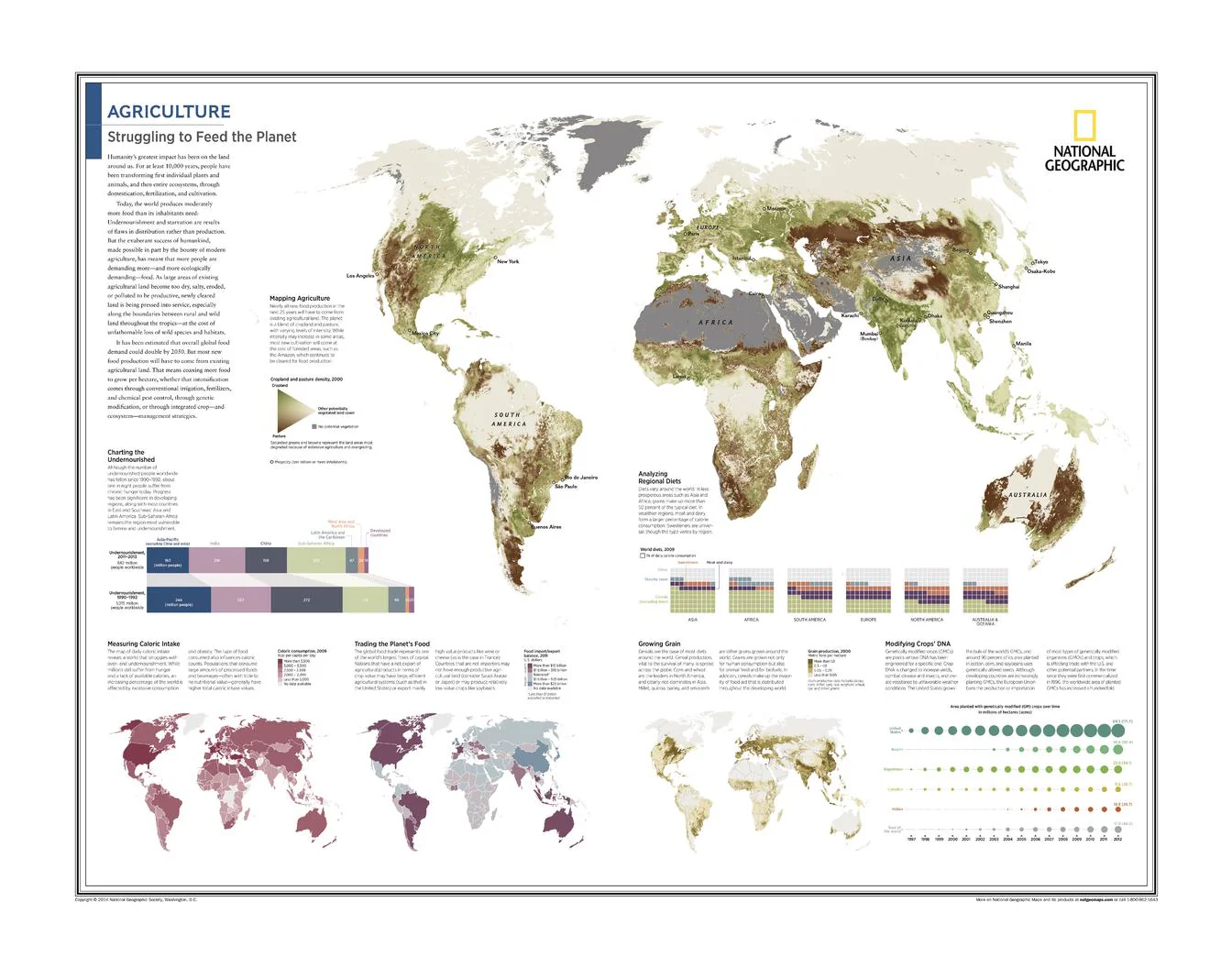
Agriculture: Struggling to Feed the Planet is a powerful, data-driven thematic map that explores one of the defining challenges of the modern world: how humanity produces, distributes, and consumes food. Drawing on National Geographic’s renowned cartographic clarity and scientific research, this map brings together multiple global datasets to reveal the pressures, inequalities, and innovations shaping the world’s food systems.
Rather than focusing on a single issue, the map presents a layered global analysis — from hunger and caloric intake to grain production, trade flows, and genetically modified crops — offering a comprehensive snapshot of agriculture in the early 21st century.
This map is part of National Geographic’s Atlas of the World (10th Edition) and represents thematic cartography at its most informative and thought-provoking.
🌍 What This Map Shows
A series of coordinated global map panels and graphics covering:
-
Mapping Agriculture — where and how food is produced
-
Charting the Undernourished — global patterns of hunger and food insecurity
-
Measuring Caloric Intake — regional differences in daily energy consumption
-
Trading the Planet’s Food — international flows of agricultural products
-
Analyzing Regional Diets — what the world eats, and where
-
Growing Grain — major cereal crops and production regions
-
Modifying Crops’ DNA — the global footprint of genetically modified agriculture
Together, these layers reveal the complex, interconnected nature of global food systems.
🧠 Why This Map Matters
-
Highlights the contrast between abundance and scarcity
-
Shows how trade links food security across continents
-
Illustrates the role of technology, including GM crops, in boosting yields
-
Encourages informed discussion about sustainability, equity, and resilience
This is a map designed not just to inform, but to spark critical thinking and conversation.
🎨 Cartography & Data Storytelling
-
Clear thematic symbology and restrained colour palettes
-
Carefully balanced layouts that make complex data readable
-
A hallmark of National Geographic’s modern atlas-style visual journalism
The design ensures that even dense information remains accessible in classrooms, libraries, and offices.
🎨 Materials, Print Quality & Hanging Options
📄 Paper (Classic Framing Option)
-
Printed on high-quality matte paper for crisp text and graphics
-
Smooth, low-glare surface — ideal for framing under glass
-
A refined option for studies, libraries, and educational spaces
🔒 Laminated (Write-On / Wipe-Off)
-
Printed on quality paper and encapsulated in protective laminate
-
Durable, waterproof, and tear-resistant
-
Write-on / wipe-off surface compatible with whiteboard markers and map dots
-
Ideal for classrooms, teaching, and facilitated discussion
🪵 Optional Timber Hang Rails — Laminated
-
Top and bottom natural timber rails provide structure and balance
-
Bottom rail adds weight so the map hangs flat and straight
-
Prevents edge curl and long-term sagging
-
Supplied with hanging cord — ready to mount on a single hook
Please allow up to 10 working days for laminated maps with hang rails.
🎨 Archival Canvas (Premium Display Option)
-
Printed on 395 gsm HP Professional Matte Canvas
-
Subtle canvas texture adds depth while preserving fine graphic detail
-
Matte surface reduces reflections compared with glass-framed prints
Archival Pigment Inks
-
Produced using Hewlett-Packard archival, fade-resistant pigment inks
-
Ensures crisp graphics, stable colour, and long-term durability
🪵 Optional Timber Hang Rails — Canvas
-
Top and bottom timber rails create a clean, gallery-style presentation
-
Bottom rail adds weight for a perfectly straight hang
-
Prevents edge curl and sag over time
-
Supplied with hanging cord — ready to mount
Please allow up to 10 working days for canvas maps with hang rails.
Canvas editions are intended for display and reference and are not write-on / wipe-off like laminated versions.
📐 Size & Format
-
Size: 711 mm × 559 mm
-
Orientation: Landscape
A wall-friendly size that balances readability with ease of display in classrooms, libraries, and home offices.
📊 Specifications
| Attribute | Details |
|---|---|
| Title | Agriculture: Struggling to Feed the Planet |
| Publisher | National Geographic |
| Year | 2015 |
| Map Type | Global thematic |
| Coverage | World |
| Themes | Agriculture, hunger, caloric intake, food trade, diets, grain, GM crops |
| Source | Atlas of the World (10th Edition), Plate 17 |
| Available Formats | Paper • Laminated • Laminated + Hang Rails • Canvas • Canvas + Hang Rails |
| Canvas Weight | 395 gsm HP Professional Matte |
| Inks (Canvas) | Hewlett-Packard archival, fade-resistant pigment inks |
| Size | 711 mm × 559 mm |
| Collections | World • Thematic Maps |
🎯 Who It’s For
-
🌍 Educators & students — geography, economics, and sustainability
-
🧪 Universities & research institutions
-
🗺️ National Geographic collectors — modern thematic cartography
-
🏠 Thoughtful home displays — data-driven wall art
-
🎁 Gift buyers — intellectually engaging and globally relevant
🤝 Our Commitment
This National Geographic thematic map is reproduced and printed in Australia with careful attention to clarity, colour accuracy, and finish. Each copy is checked and packed with care, ensuring it arrives ready to inform and endure.
🛒 Understand the world through food — choose Paper, Laminated, or Canvas, with optional timber hang rails, and order Agriculture: Struggling to Feed the Planet (2015) today.
Product Information
Product Information
Shipping & Returns
Shipping & Returns
Description
Agriculture: Struggling to Feed the Planet (2015)
Publisher: National Geographic
Published: 25 February 2015
Size: 711 mm (W) × 559 mm (H)
Orientation: Landscape
Map Type: Global Thematic Map
Source: Atlas of the World, 10th Edition — Plate 17
Agriculture: Struggling to Feed the Planet is a powerful, data-driven thematic map that explores one of the defining challenges of the modern world: how humanity produces, distributes, and consumes food. Drawing on National Geographic’s renowned cartographic clarity and scientific research, this map brings together multiple global datasets to reveal the pressures, inequalities, and innovations shaping the world’s food systems.
Rather than focusing on a single issue, the map presents a layered global analysis — from hunger and caloric intake to grain production, trade flows, and genetically modified crops — offering a comprehensive snapshot of agriculture in the early 21st century.
This map is part of National Geographic’s Atlas of the World (10th Edition) and represents thematic cartography at its most informative and thought-provoking.
🌍 What This Map Shows
A series of coordinated global map panels and graphics covering:
-
Mapping Agriculture — where and how food is produced
-
Charting the Undernourished — global patterns of hunger and food insecurity
-
Measuring Caloric Intake — regional differences in daily energy consumption
-
Trading the Planet’s Food — international flows of agricultural products
-
Analyzing Regional Diets — what the world eats, and where
-
Growing Grain — major cereal crops and production regions
-
Modifying Crops’ DNA — the global footprint of genetically modified agriculture
Together, these layers reveal the complex, interconnected nature of global food systems.
🧠 Why This Map Matters
-
Highlights the contrast between abundance and scarcity
-
Shows how trade links food security across continents
-
Illustrates the role of technology, including GM crops, in boosting yields
-
Encourages informed discussion about sustainability, equity, and resilience
This is a map designed not just to inform, but to spark critical thinking and conversation.
🎨 Cartography & Data Storytelling
-
Clear thematic symbology and restrained colour palettes
-
Carefully balanced layouts that make complex data readable
-
A hallmark of National Geographic’s modern atlas-style visual journalism
The design ensures that even dense information remains accessible in classrooms, libraries, and offices.
🎨 Materials, Print Quality & Hanging Options
📄 Paper (Classic Framing Option)
-
Printed on high-quality matte paper for crisp text and graphics
-
Smooth, low-glare surface — ideal for framing under glass
-
A refined option for studies, libraries, and educational spaces
🔒 Laminated (Write-On / Wipe-Off)
-
Printed on quality paper and encapsulated in protective laminate
-
Durable, waterproof, and tear-resistant
-
Write-on / wipe-off surface compatible with whiteboard markers and map dots
-
Ideal for classrooms, teaching, and facilitated discussion
🪵 Optional Timber Hang Rails — Laminated
-
Top and bottom natural timber rails provide structure and balance
-
Bottom rail adds weight so the map hangs flat and straight
-
Prevents edge curl and long-term sagging
-
Supplied with hanging cord — ready to mount on a single hook
Please allow up to 10 working days for laminated maps with hang rails.
🎨 Archival Canvas (Premium Display Option)
-
Printed on 395 gsm HP Professional Matte Canvas
-
Subtle canvas texture adds depth while preserving fine graphic detail
-
Matte surface reduces reflections compared with glass-framed prints
Archival Pigment Inks
-
Produced using Hewlett-Packard archival, fade-resistant pigment inks
-
Ensures crisp graphics, stable colour, and long-term durability
🪵 Optional Timber Hang Rails — Canvas
-
Top and bottom timber rails create a clean, gallery-style presentation
-
Bottom rail adds weight for a perfectly straight hang
-
Prevents edge curl and sag over time
-
Supplied with hanging cord — ready to mount
Please allow up to 10 working days for canvas maps with hang rails.
Canvas editions are intended for display and reference and are not write-on / wipe-off like laminated versions.
📐 Size & Format
-
Size: 711 mm × 559 mm
-
Orientation: Landscape
A wall-friendly size that balances readability with ease of display in classrooms, libraries, and home offices.
📊 Specifications
| Attribute | Details |
|---|---|
| Title | Agriculture: Struggling to Feed the Planet |
| Publisher | National Geographic |
| Year | 2015 |
| Map Type | Global thematic |
| Coverage | World |
| Themes | Agriculture, hunger, caloric intake, food trade, diets, grain, GM crops |
| Source | Atlas of the World (10th Edition), Plate 17 |
| Available Formats | Paper • Laminated • Laminated + Hang Rails • Canvas • Canvas + Hang Rails |
| Canvas Weight | 395 gsm HP Professional Matte |
| Inks (Canvas) | Hewlett-Packard archival, fade-resistant pigment inks |
| Size | 711 mm × 559 mm |
| Collections | World • Thematic Maps |
🎯 Who It’s For
-
🌍 Educators & students — geography, economics, and sustainability
-
🧪 Universities & research institutions
-
🗺️ National Geographic collectors — modern thematic cartography
-
🏠 Thoughtful home displays — data-driven wall art
-
🎁 Gift buyers — intellectually engaging and globally relevant
🤝 Our Commitment
This National Geographic thematic map is reproduced and printed in Australia with careful attention to clarity, colour accuracy, and finish. Each copy is checked and packed with care, ensuring it arrives ready to inform and endure.
🛒 Understand the world through food — choose Paper, Laminated, or Canvas, with optional timber hang rails, and order Agriculture: Struggling to Feed the Planet (2015) today.


