Alps, Europes Backbone - Published 1965 by National Geographic
Relief Map | The Alpine Arc Across Europe | Wall Format (631 × 478 mm) | Premium Finishes
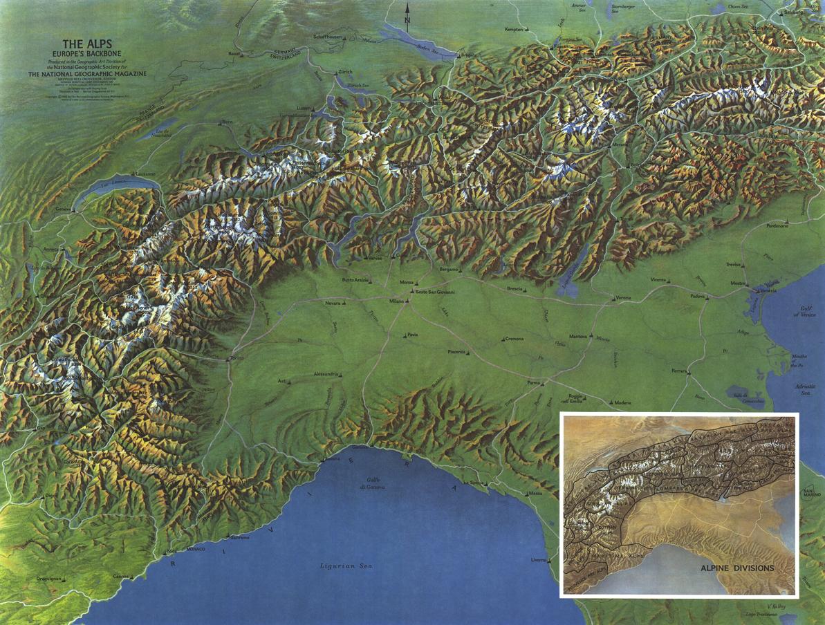
A beautifully rendered relief map capturing the dramatic sweep of Europe’s great mountain chain, Alps — Europe’s Backbone brings the Alpine landscape into vivid, tactile focus. Published by National Geographic in September 1965, this classic piece showcases the topography, structure, and scale of the Alps with remarkable clarity.
Released alongside a regional map of Switzerland, Austria, and northern Italy—and in the same year as The Sound of Music—this map reflects a moment when global fascination with the Alpine landscape surged, capturing both its natural grandeur and cultural resonance.
Why This Map Stands Out
A classic relief depiction
Elevated terrain shading brings mountains, valleys, and passes to life.
The spine of Europe revealed
Shows the full arc of the Alps across multiple countries.
A mid-century National Geographic classic
Elegant, timeless cartography from a golden era of mapmaking.
Cultural and geographic significance
Captures a region central to European history, travel, and identity.
A refined wall display
Compact yet richly detailed—ideal for both study and décor.
🗺️ What the Map Shows
- The full extent of the Alpine mountain range across Europe
- Major regions including parts of Switzerland, Austria, northern Italy, and surrounding areas
- Detailed relief shading highlighting peaks, ridges, and valleys
- Key geographic features shaping the Alpine landscape
- The structure of the Alps as Europe’s natural “backbone”
- A visual sense of elevation, terrain, and mountain continuity
📐 Size & Format
631 mm (W) × 478 mm (H)
Landscape orientation
A compact, elegant format ideal for:
- Home offices and studies
- Classrooms and geography departments
- Libraries and travel-inspired interiors
- Feature walls celebrating European landscapes
✨ Premium Finishes
| Format | Description |
|---|---|
| 📜 Paper (160 gsm) | Heavyweight matte-coated paper—ideal for framing. Preserves fine relief detail and tonal depth. |
| 🧼 Laminated (Encapsulated) | Sealed in 2 × 80-micron gloss laminate. Durable, wipe-clean, and suitable for regular reference. |
| 🪵 Laminated + Timber Hang Rails | Laminated map mounted with lacquered natural timber rails and hanging cord—ready to display. |
| 🖼️ Canvas (395 gsm HP Professional Matte) | Printed with archival pigment inks. Rich texture enhances depth and visual presence. |
| 🪵 Canvas + Timber Hang Rails | Canvas paired with timber rails for a refined, gallery-style presentation. |
🔨 Please allow up to 10 working days for professionally mounted hang-railed finishes.
📊 Specifications
| Feature | Detail |
|---|---|
| Title | Alps — Europe’s Backbone |
| Publisher | National Geographic |
| Published | 1965 |
| Dimensions | 631 mm × 478 mm |
| Orientation | Landscape |
| Map Type | Physical / Relief |
| Coverage | Alpine region, Europe |
| Collections | Europe, Historical, Regional, Physical |
| Materials | 160 gsm matte paper / 2 × 80-micron laminate / 395 gsm HP Professional Matte Canvas |
| Printing | Pigment-based, fade-resistant inks |
| Origin | Printed in Australia |
🎯 Ideal For
- Lovers of European landscapes and mountain regions
- Students and educators of physical geography
- Collectors of classic National Geographic maps
- Interiors inspired by travel, nature, and alpine culture
- Gift buyers seeking a timeless and elegant map
🏔️ The Backbone of a Continent
The Alps define Europe’s geography:
- A vast mountain chain shaping climate, culture, and travel
- Valleys and passes connecting regions across borders
- Peaks that have inspired exploration, art, and storytelling
- A landscape both formidable and deeply beautiful
This map captures that essence—revealing the Alps as both a natural barrier and a unifying feature of Europe.
🤝 Our Commitment
- Printed in Australia using archival-quality production
- Faithfully reproduced to preserve relief detail and tonal clarity
- Premium materials selected for durability and longevity
- Each map is hand-checked before dispatch
- Carefully packaged for safe delivery
🚚 Delivery
- Paper, Laminated, Canvas (rolled): Dispatch within 1–2 business days
- Hang-Railed Maps: Made to order—allow up to 10 working days
- Packaging: Securely rolled in protective tubing
Bring Europe’s great mountain range to your wall—
a map that captures the Alps in timeless relief and detail.
👉 Order now and experience the backbone of Europe.
Original: $57.20
-65%$57.20
$20.02Product Information
Product Information
Shipping & Returns
Shipping & Returns
Description
Relief Map | The Alpine Arc Across Europe | Wall Format (631 × 478 mm) | Premium Finishes
A beautifully rendered relief map capturing the dramatic sweep of Europe’s great mountain chain, Alps — Europe’s Backbone brings the Alpine landscape into vivid, tactile focus. Published by National Geographic in September 1965, this classic piece showcases the topography, structure, and scale of the Alps with remarkable clarity.
Released alongside a regional map of Switzerland, Austria, and northern Italy—and in the same year as The Sound of Music—this map reflects a moment when global fascination with the Alpine landscape surged, capturing both its natural grandeur and cultural resonance.
Why This Map Stands Out
A classic relief depiction
Elevated terrain shading brings mountains, valleys, and passes to life.
The spine of Europe revealed
Shows the full arc of the Alps across multiple countries.
A mid-century National Geographic classic
Elegant, timeless cartography from a golden era of mapmaking.
Cultural and geographic significance
Captures a region central to European history, travel, and identity.
A refined wall display
Compact yet richly detailed—ideal for both study and décor.
🗺️ What the Map Shows
- The full extent of the Alpine mountain range across Europe
- Major regions including parts of Switzerland, Austria, northern Italy, and surrounding areas
- Detailed relief shading highlighting peaks, ridges, and valleys
- Key geographic features shaping the Alpine landscape
- The structure of the Alps as Europe’s natural “backbone”
- A visual sense of elevation, terrain, and mountain continuity
📐 Size & Format
631 mm (W) × 478 mm (H)
Landscape orientation
A compact, elegant format ideal for:
- Home offices and studies
- Classrooms and geography departments
- Libraries and travel-inspired interiors
- Feature walls celebrating European landscapes
✨ Premium Finishes
| Format | Description |
|---|---|
| 📜 Paper (160 gsm) | Heavyweight matte-coated paper—ideal for framing. Preserves fine relief detail and tonal depth. |
| 🧼 Laminated (Encapsulated) | Sealed in 2 × 80-micron gloss laminate. Durable, wipe-clean, and suitable for regular reference. |
| 🪵 Laminated + Timber Hang Rails | Laminated map mounted with lacquered natural timber rails and hanging cord—ready to display. |
| 🖼️ Canvas (395 gsm HP Professional Matte) | Printed with archival pigment inks. Rich texture enhances depth and visual presence. |
| 🪵 Canvas + Timber Hang Rails | Canvas paired with timber rails for a refined, gallery-style presentation. |
🔨 Please allow up to 10 working days for professionally mounted hang-railed finishes.
📊 Specifications
| Feature | Detail |
|---|---|
| Title | Alps — Europe’s Backbone |
| Publisher | National Geographic |
| Published | 1965 |
| Dimensions | 631 mm × 478 mm |
| Orientation | Landscape |
| Map Type | Physical / Relief |
| Coverage | Alpine region, Europe |
| Collections | Europe, Historical, Regional, Physical |
| Materials | 160 gsm matte paper / 2 × 80-micron laminate / 395 gsm HP Professional Matte Canvas |
| Printing | Pigment-based, fade-resistant inks |
| Origin | Printed in Australia |
🎯 Ideal For
- Lovers of European landscapes and mountain regions
- Students and educators of physical geography
- Collectors of classic National Geographic maps
- Interiors inspired by travel, nature, and alpine culture
- Gift buyers seeking a timeless and elegant map
🏔️ The Backbone of a Continent
The Alps define Europe’s geography:
- A vast mountain chain shaping climate, culture, and travel
- Valleys and passes connecting regions across borders
- Peaks that have inspired exploration, art, and storytelling
- A landscape both formidable and deeply beautiful
This map captures that essence—revealing the Alps as both a natural barrier and a unifying feature of Europe.
🤝 Our Commitment
- Printed in Australia using archival-quality production
- Faithfully reproduced to preserve relief detail and tonal clarity
- Premium materials selected for durability and longevity
- Each map is hand-checked before dispatch
- Carefully packaged for safe delivery
🚚 Delivery
- Paper, Laminated, Canvas (rolled): Dispatch within 1–2 business days
- Hang-Railed Maps: Made to order—allow up to 10 working days
- Packaging: Securely rolled in protective tubing
Bring Europe’s great mountain range to your wall—
a map that captures the Alps in timeless relief and detail.
👉 Order now and experience the backbone of Europe.


