Amazonia, a World Resource At Risk - Published 1992 by National Geographic
Physical & Environmental Map | Amazon Basin, Rainforest & Global Impact | Large Wall Format (707 × 512 mm) | Premium Finishes
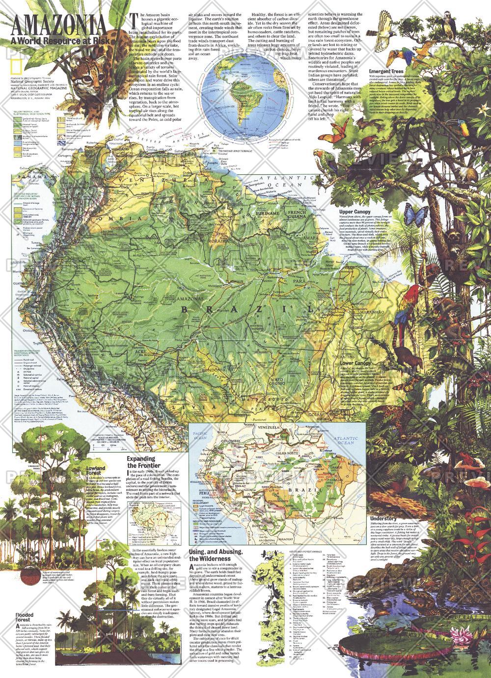
A powerful exploration of one of Earth’s most vital ecosystems, Amazonia — A World Resource at Risk reveals the scale, beauty, and fragility of the Amazon Basin. Published by National Geographic in August 1992, this map combines detailed physical mapping with rich illustration and insight—showing why the Amazon matters not just regionally, but globally.
More than a map, it is a visual narrative of a rainforest that plays a critical role in regulating climate, supporting biodiversity, and sustaining life far beyond South America.
Why This Map Stands Out
A globally significant ecosystem
Explores the Amazon Basin—one of the most important environmental regions on Earth.
Blends science and storytelling
Combines physical geography with illustrations and educational insights.
Focus on environmental impact
Highlights the connection between the Amazon’s health and the planet’s wellbeing.
National Geographic authority
Clear, engaging cartography supported by trusted research.
A meaningful and visually rich display
Ideal for both learning and creating a powerful wall statement.
🗺️ What the Map Shows
- The full extent of the Amazon Basin across South America
- The course and scale of the Amazon River and its tributaries
- Dense rainforest regions and major ecological zones
- Physical features including rivers, floodplains, and terrain
- Illustrated insights into the region’s biodiversity and ecosystems
- Areas facing environmental pressure and emerging threats
- The relationship between the Amazon and the global climate system
📐 Size & Format
707 mm (H) × 512 mm (W)
Portrait orientation
A balanced format ideal for:
- Classrooms and environmental studies
- Offices and sustainability-focused spaces
- Home studies and libraries
- Interiors inspired by nature and global awareness
✨ Premium Finishes
| Format | Description |
|---|---|
| 📜 Paper (160 gsm) | Heavyweight matte-coated paper—ideal for framing. Preserves colour depth and fine detail. |
| 🧼 Laminated (Encapsulated) | Sealed in 2 × 80-micron gloss laminate. Durable, wipe-clean, and suitable for regular reference. |
| 🪵 Laminated + Timber Hang Rails | Laminated map mounted with lacquered natural timber rails and hanging cord—ready to display. |
| 🖼️ Canvas (395 gsm HP Professional Matte) | Printed with archival pigment inks. Rich texture enhances depth and visual presence. |
| 🪵 Canvas + Timber Hang Rails | Canvas paired with timber rails for a refined, gallery-style presentation. |
🔨 Please allow up to 10 working days for professionally mounted hang-railed finishes.
📊 Specifications
| Feature | Detail |
|---|---|
| Title | Amazonia — A World Resource at Risk |
| Publisher | National Geographic |
| Published | 1992 |
| Dimensions | 707 mm × 512 mm |
| Orientation | Landscape |
| Map Type | Physical / Environmental |
| Coverage | Amazon Basin, South America |
| Collections | South America, Historical |
| Materials | 160 gsm matte paper / 2 × 80-micron laminate / 395 gsm HP Professional Matte Canvas |
| Printing | Pigment-based, fade-resistant inks |
| Origin | Printed in Australia |
🎯 Ideal For
- Students and educators of geography and environmental science
- Conservationists and lovers of rainforest ecosystems
- Collectors of National Geographic thematic maps
- Interiors seeking a lush, nature-inspired display
- Gift buyers looking for a thoughtful and educational map
🌿 The Lungs of the Planet
The Amazon is more than a rainforest:
- A vast network of rivers and ecosystems
- Home to unparalleled biodiversity
- A regulator of global climate and weather systems
- A region under increasing environmental pressure
This map captures both its beauty and its vulnerability—revealing why the Amazon remains one of the most important places on Earth.
🤝 Our Commitment
- Printed in Australia using archival-quality production
- Faithfully reproduced to preserve colour, clarity, and detail
- Premium materials selected for durability and longevity
- Each map is hand-checked before dispatch
- Carefully packaged for safe delivery
🚚 Delivery
- Paper, Laminated, Canvas (rolled): Dispatch within 1–2 business days
- Hang-Railed Maps: Made to order—allow up to 10 working days
- Packaging: Securely rolled in protective tubing
Explore the rainforest that shapes the world—
a map that brings Amazonia’s beauty, scale, and urgency into focus.
👉 Order now and add this vital global landscape to your wall.
Original: $57.20
-65%$57.20
$20.02Product Information
Product Information
Shipping & Returns
Shipping & Returns
Description
Physical & Environmental Map | Amazon Basin, Rainforest & Global Impact | Large Wall Format (707 × 512 mm) | Premium Finishes
A powerful exploration of one of Earth’s most vital ecosystems, Amazonia — A World Resource at Risk reveals the scale, beauty, and fragility of the Amazon Basin. Published by National Geographic in August 1992, this map combines detailed physical mapping with rich illustration and insight—showing why the Amazon matters not just regionally, but globally.
More than a map, it is a visual narrative of a rainforest that plays a critical role in regulating climate, supporting biodiversity, and sustaining life far beyond South America.
Why This Map Stands Out
A globally significant ecosystem
Explores the Amazon Basin—one of the most important environmental regions on Earth.
Blends science and storytelling
Combines physical geography with illustrations and educational insights.
Focus on environmental impact
Highlights the connection between the Amazon’s health and the planet’s wellbeing.
National Geographic authority
Clear, engaging cartography supported by trusted research.
A meaningful and visually rich display
Ideal for both learning and creating a powerful wall statement.
🗺️ What the Map Shows
- The full extent of the Amazon Basin across South America
- The course and scale of the Amazon River and its tributaries
- Dense rainforest regions and major ecological zones
- Physical features including rivers, floodplains, and terrain
- Illustrated insights into the region’s biodiversity and ecosystems
- Areas facing environmental pressure and emerging threats
- The relationship between the Amazon and the global climate system
📐 Size & Format
707 mm (H) × 512 mm (W)
Portrait orientation
A balanced format ideal for:
- Classrooms and environmental studies
- Offices and sustainability-focused spaces
- Home studies and libraries
- Interiors inspired by nature and global awareness
✨ Premium Finishes
| Format | Description |
|---|---|
| 📜 Paper (160 gsm) | Heavyweight matte-coated paper—ideal for framing. Preserves colour depth and fine detail. |
| 🧼 Laminated (Encapsulated) | Sealed in 2 × 80-micron gloss laminate. Durable, wipe-clean, and suitable for regular reference. |
| 🪵 Laminated + Timber Hang Rails | Laminated map mounted with lacquered natural timber rails and hanging cord—ready to display. |
| 🖼️ Canvas (395 gsm HP Professional Matte) | Printed with archival pigment inks. Rich texture enhances depth and visual presence. |
| 🪵 Canvas + Timber Hang Rails | Canvas paired with timber rails for a refined, gallery-style presentation. |
🔨 Please allow up to 10 working days for professionally mounted hang-railed finishes.
📊 Specifications
| Feature | Detail |
|---|---|
| Title | Amazonia — A World Resource at Risk |
| Publisher | National Geographic |
| Published | 1992 |
| Dimensions | 707 mm × 512 mm |
| Orientation | Landscape |
| Map Type | Physical / Environmental |
| Coverage | Amazon Basin, South America |
| Collections | South America, Historical |
| Materials | 160 gsm matte paper / 2 × 80-micron laminate / 395 gsm HP Professional Matte Canvas |
| Printing | Pigment-based, fade-resistant inks |
| Origin | Printed in Australia |
🎯 Ideal For
- Students and educators of geography and environmental science
- Conservationists and lovers of rainforest ecosystems
- Collectors of National Geographic thematic maps
- Interiors seeking a lush, nature-inspired display
- Gift buyers looking for a thoughtful and educational map
🌿 The Lungs of the Planet
The Amazon is more than a rainforest:
- A vast network of rivers and ecosystems
- Home to unparalleled biodiversity
- A regulator of global climate and weather systems
- A region under increasing environmental pressure
This map captures both its beauty and its vulnerability—revealing why the Amazon remains one of the most important places on Earth.
🤝 Our Commitment
- Printed in Australia using archival-quality production
- Faithfully reproduced to preserve colour, clarity, and detail
- Premium materials selected for durability and longevity
- Each map is hand-checked before dispatch
- Carefully packaged for safe delivery
🚚 Delivery
- Paper, Laminated, Canvas (rolled): Dispatch within 1–2 business days
- Hang-Railed Maps: Made to order—allow up to 10 working days
- Packaging: Securely rolled in protective tubing
Explore the rainforest that shapes the world—
a map that brings Amazonia’s beauty, scale, and urgency into focus.
👉 Order now and add this vital global landscape to your wall.


