Ancient Maya World (1989)
Publisher: National Geographic
Published: October 1989
Scale: 1 : 2,205,000
Size: 687 mm (W) × 512 mm (H)
Orientation: Landscape
Map Type: Historical & Cultural Thematic Map
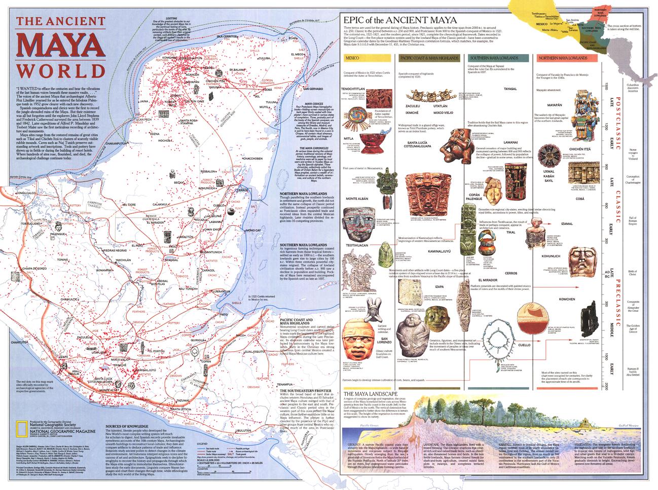
Published in 1989, Ancient Maya World invites you into one of the most sophisticated civilisations of the ancient Americas. Created to accompany the Land of the Maya map and a series of National Geographic features — including “La Ruta Maya” — this richly detailed sheet brings together geography, trade, travel, and history to illuminate the Maya world at its height.
Far more than a political snapshot, the map reveals how landscape shaped civilisation: trade routes threading through jungles and highlands, centres of power linked by causeways and waterways, and regional patterns that defined daily life. Clear explanatory notes outline the major eras of Maya history, helping viewers understand how the civilisation evolved over time.
This is a map designed to be read, studied, and explored — a classic example of National Geographic’s late-20th-century thematic storytelling.
🗺️ What This Map Shows
-
The geographic extent of the Maya civilisation
-
Trade and travel routes connecting cities and regions
-
Key urban centres and ceremonial sites
-
Landscape features — lowlands, highlands, rivers, and coastlines
-
Historical eras of Maya development, clearly explained
Together, these layers reveal a dynamic civilisation deeply connected to its environment.
🕰️ Understanding the Maya World
-
Explains the chronological phases of Maya history
-
Shows how geography influenced settlement, trade, and power
-
Highlights regional variation across the Maya realm
-
Places culture, economy, and environment in direct relationship
This map helps transform dates and names into a coherent, spatial story.
🎨 Cartography & Visual Storytelling
-
Carefully balanced colour and symbology for clarity
-
Dense information presented without visual overload
-
A hallmark of National Geographic’s educational, atlas-style cartography
-
Designed to work equally well in classrooms, libraries, and private collections
🎨 Materials, Print Quality & Hanging Options
📄 Paper (Classic Framing Option)
-
Printed on high-quality matte paper for crisp detail and accurate colour
-
Smooth, low-glare surface — ideal for framing under glass
-
A traditional choice for studies, libraries, and educational spaces
🔒 Laminated (Write-On / Wipe-Off)
-
Printed on quality paper and encapsulated in protective laminate
-
Durable, waterproof, and tear-resistant
-
Write-on / wipe-off surface compatible with whiteboard markers and map dots
-
Ideal for classrooms, teaching, and interactive discussion
🪵 Optional Timber Hang Rails — Laminated
-
Top and bottom natural timber rails provide structure and balance
-
Bottom rail adds weight so the map hangs flat and straight
-
Prevents edge curl and long-term sagging
-
Supplied with hanging cord — ready to mount on a single hook
Please allow up to 10 working days for laminated maps with hang rails.
🎨 Archival Canvas (Premium Display Option)
-
Printed on 395 gsm HP Professional Matte Canvas
-
Subtle canvas texture adds depth while preserving fine linework
-
Matte surface reduces reflections compared with glass-framed prints
Archival Pigment Inks
-
Produced using Hewlett-Packard archival, fade-resistant pigment inks
-
Ensures crisp typography, stable colour, and long-term durability
🪵 Optional Timber Hang Rails — Canvas
-
Top and bottom timber rails create a clean, gallery-style presentation
-
Bottom rail adds weight for a perfectly straight hang
-
Prevents edge curl and sag over time
-
Supplied with hanging cord — ready to mount
Please allow up to 10 working days for canvas maps with hang rails.
Canvas editions are intended for display and reference and are not write-on / wipe-off like laminated versions.
📐 Size & Scale
-
Size: 687 mm × 512 mm
-
Scale: 1 : 2,205,000
A wall-friendly format that balances detailed study with easy display.
📊 Specifications
| Attribute | Details |
|---|---|
| Title | Ancient Maya World |
| Publisher | National Geographic |
| Year | 1989 |
| Coverage | Maya civilisation (Mesoamerica) |
| Map Type | Historical & cultural thematic |
| Features | Trade routes, travel, landscape, historical eras |
| Companion Content | Land of the Maya map; “La Ruta Maya” articles |
| Scale | 1 : 2,205,000 |
| Available Formats | Paper • Laminated • Laminated + Hang Rails • Canvas • Canvas + Hang Rails |
| Canvas Weight | 395 gsm HP Professional Matte |
| Inks (Canvas) | Hewlett-Packard archival, fade-resistant pigment inks |
| Size | 687 mm × 512 mm |
| Orientation | Landscape |
🎯 Who It’s For
-
🏛️ Educators & students — ancient history and Mesoamerican studies
-
🗺️ National Geographic collectors — a classic 1980s thematic map
-
🎓 Libraries & museums — cultural and archaeological context
-
🏠 Homes & studies — intellectually rich wall art
-
🎁 Gift buyers — thoughtful and educational
🤝 Our Commitment
This National Geographic map is reproduced and printed in Australia with careful attention to colour accuracy and fine detail. Each print is checked and packed with care, ensuring it arrives ready to inform, inspire, and endure.
🛒 Explore the Maya world through place and time — choose Paper, Laminated, or Canvas, with optional timber hang rails, and order Ancient Maya World (1989) today.


