Antique Style World Wall Map 2000 x 1150mm
A Timeless Masterpiece of Cartographic Elegance
Award-Winning Design | Available in Paper, Laminated, or Canvas with Optional Timber Rails
Scale: 1:20,000,000 | Size: 2000 mm (W) x 1150 mm (H)
Crafted in Australia
🌍 Overview
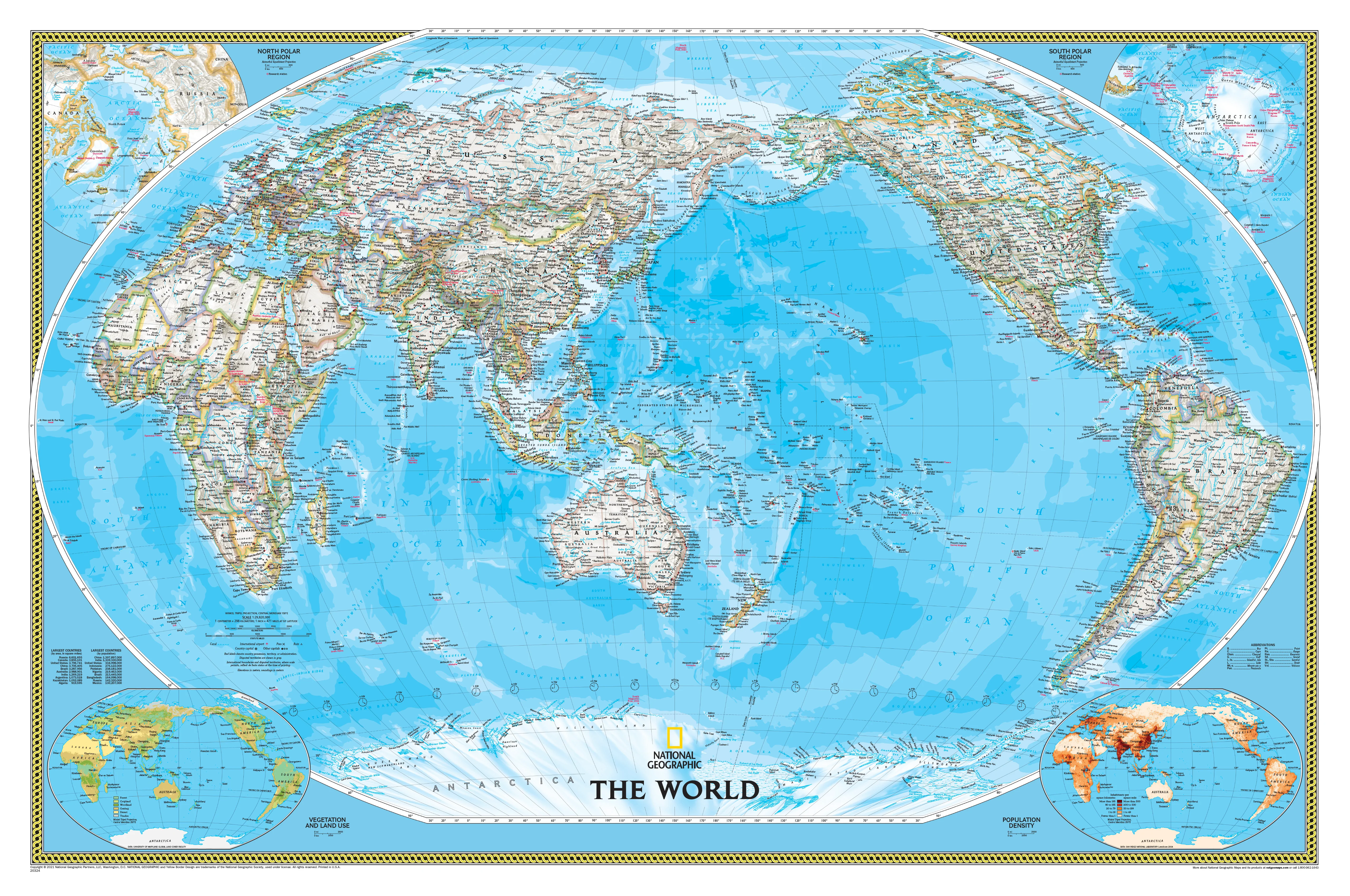
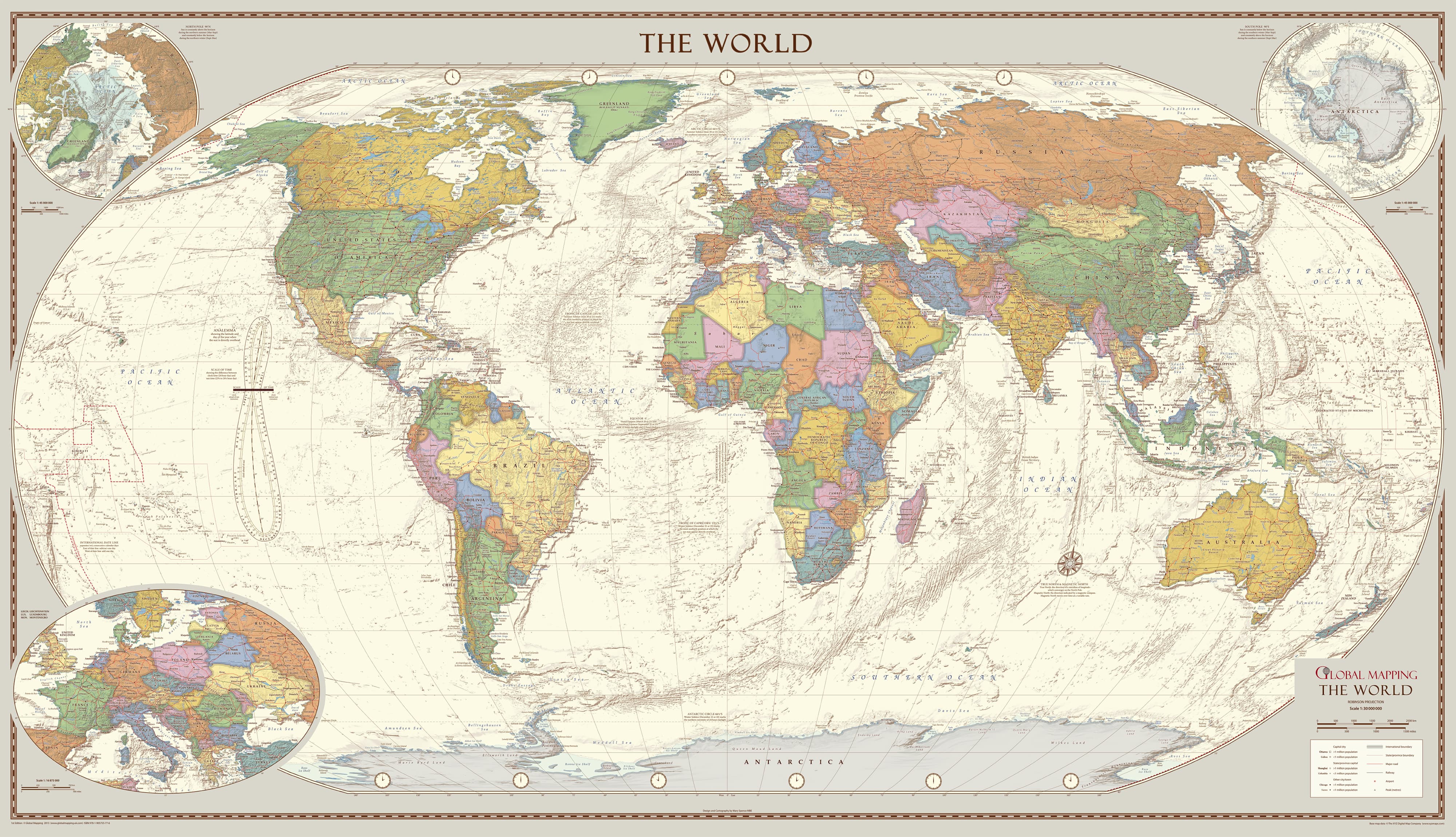
Few things combine aesthetic charm and educational value like a well-made world map. This Antique Style World Wall Map does just that—on an impressive scale. Measuring two metres wide, this wall map is a stunning visual centrepiece that blends classic cartographic design with modern geographic accuracy, ideal for home studies, offices, schools, or anywhere that calls for a statement piece.
Featuring soft, muted colours, subtle hill shading, and classical serif typography, the map evokes the refined sensibilities of 19th-century atlas design. Yet it's far from outdated: the geography is fully updated, the visual balance is impeccable, and the content includes fascinating educational insights—from the path of the sun to the extremes of the polar regions.
🏆 Recognised for Excellence
This map is more than decorative—it's award-winning.
-
Voted Best Printed Map by the British Cartographic Society (BCS)
-
Winner of the prestigious BCS Cup for Best Overall Map
-
Honoured for its design clarity, aesthetic balance, and cartographic detail
Whether you're a map enthusiast, educator, or simply a lover of timeless design, this piece offers both substance and style in abundance.
✨ Key Cartographic Features
-
Antique-Style Colour Palette
Soft creams, muted greens, and subtle blues create a sophisticated vintage aesthetic that complements both modern and traditional interiors. -
Hill Shading and Terrain Relief
Subtle gradients provide topographic context, giving the map an added layer of realism and depth. -
Insets of the Polar Regions
Includes focused views of both the Arctic and Antarctic, which are often omitted from standard projections. -
Enlargement of Central Europe
Central Europe is shown in greater detail to accommodate dense geographical data in a highly populated region. -
Analemma Diagram
A unique feature showing the position of the sun throughout the year—ideal for those interested in astronomy, timekeeping, and Earth's solar geometry. -
Explanatory Notes
Insightful annotations explain the Tropics of Cancer and Capricorn, the Arctic and Antarctic Circles, and the principles behind solar time versus standard time.
📐 Product Specifications
| Detail | Specification |
|---|---|
| Scale | 1:20,000,000 |
| Dimensions | 2000 mm (W) x 1150 mm (H) |
| Orientation | Landscape |
| Printed In | Australia |
| Available Finishes | Paper, Laminated, Canvas |
| Optional Extras | Timber hang rails (Canvas version only) |
🖨️ Finish Options
Choose from three premium-quality finishes to suit your space and purpose:
🧾 160 gsm Matte-Coated Paper
-
High-quality matte finish ideal for framing under glass
-
Lightweight yet durable
-
Crisp image reproduction for a clean and elegant look
🛡️ Encapsulated Gloss Laminate
-
Sealed in two sheets of 80-micron gloss laminate
-
Durable, water-resistant, and tear-resistant
-
Wipe-clean surface – ideal for offices, classrooms, or interactive use
-
Great for frequent handling or marking with dry-erase pens
🖼️ 395 gsm HP Professional Matte Canvas
-
Printed using pigment-based archival inks for exceptional colour depth
-
Fade-resistant, tactile, and gallery-worthy
-
Provides a warm, museum-grade finish perfect for home or corporate spaces
-
Ideal for hanging with timber rails or traditional mounting
Optional Timber Hanging Rails – Laminated & Canvas Only
Upgrade your map into a ready-to-hang showpiece:
-
Natural timber hang rails attached to top and bottom
-
Coated in a clear satin lacquer for protection and elegance
-
Top rail includes a hanging cord—simple to hang on a single hook or nail
-
Assembled by our professional framer with attention to detail
-
Please allow up to 10 business days for hang rail preparation
✅ Benefits at a Glance
| Benefit | Why It Matters |
|---|---|
| Large Format (2m wide) | Makes a visual statement while allowing for fine detail |
| Award-Winning Design | Recognised for excellence by the BCS |
| Educational Content Included | Analemma, tropics, timekeeping – not just geography |
| Multiple Finish Options | Customise for any room, use, or interior style |
| Archival Inks on Canvas | Fade-resistant and long-lasting print quality |
| Timber Rails Available | Classic look, no framing needed, easy to hang |
| Made in Australia | Locally printed and assembled with expert craftsmanship |
Perfect For:
-
Home libraries, dens, and reading rooms
-
Corporate offices, boardrooms, and reception areas
-
Educational spaces and geography classrooms
-
Map collectors, designers, and historians
-
Gifts for travel lovers, academics, or those hard to shop for
Timeless, Educational, and Beautiful
The Antique Style World Wall Map is more than decoration—it's a piece of geographic storytelling. With its blend of historical aesthetics and modern cartographic accuracy, it brings a sense of wonder and discovery to any space.
Whether you're using it to teach, plan, explore, or simply admire, this map is a remarkable way to connect with the world—and with history.
Add to your cart today and enjoy a map that is as enduring as it is elegant.
Original: $214.60
-65%$214.60
$75.11Product Information
Product Information
Shipping & Returns
Shipping & Returns
Description
A Timeless Masterpiece of Cartographic Elegance
Award-Winning Design | Available in Paper, Laminated, or Canvas with Optional Timber Rails
Scale: 1:20,000,000 | Size: 2000 mm (W) x 1150 mm (H)
Crafted in Australia
🌍 Overview
Few things combine aesthetic charm and educational value like a well-made world map. This Antique Style World Wall Map does just that—on an impressive scale. Measuring two metres wide, this wall map is a stunning visual centrepiece that blends classic cartographic design with modern geographic accuracy, ideal for home studies, offices, schools, or anywhere that calls for a statement piece.
Featuring soft, muted colours, subtle hill shading, and classical serif typography, the map evokes the refined sensibilities of 19th-century atlas design. Yet it's far from outdated: the geography is fully updated, the visual balance is impeccable, and the content includes fascinating educational insights—from the path of the sun to the extremes of the polar regions.
🏆 Recognised for Excellence
This map is more than decorative—it's award-winning.
-
Voted Best Printed Map by the British Cartographic Society (BCS)
-
Winner of the prestigious BCS Cup for Best Overall Map
-
Honoured for its design clarity, aesthetic balance, and cartographic detail
Whether you're a map enthusiast, educator, or simply a lover of timeless design, this piece offers both substance and style in abundance.
✨ Key Cartographic Features
-
Antique-Style Colour Palette
Soft creams, muted greens, and subtle blues create a sophisticated vintage aesthetic that complements both modern and traditional interiors. -
Hill Shading and Terrain Relief
Subtle gradients provide topographic context, giving the map an added layer of realism and depth. -
Insets of the Polar Regions
Includes focused views of both the Arctic and Antarctic, which are often omitted from standard projections. -
Enlargement of Central Europe
Central Europe is shown in greater detail to accommodate dense geographical data in a highly populated region. -
Analemma Diagram
A unique feature showing the position of the sun throughout the year—ideal for those interested in astronomy, timekeeping, and Earth's solar geometry. -
Explanatory Notes
Insightful annotations explain the Tropics of Cancer and Capricorn, the Arctic and Antarctic Circles, and the principles behind solar time versus standard time.
📐 Product Specifications
| Detail | Specification |
|---|---|
| Scale | 1:20,000,000 |
| Dimensions | 2000 mm (W) x 1150 mm (H) |
| Orientation | Landscape |
| Printed In | Australia |
| Available Finishes | Paper, Laminated, Canvas |
| Optional Extras | Timber hang rails (Canvas version only) |
🖨️ Finish Options
Choose from three premium-quality finishes to suit your space and purpose:
🧾 160 gsm Matte-Coated Paper
-
High-quality matte finish ideal for framing under glass
-
Lightweight yet durable
-
Crisp image reproduction for a clean and elegant look
🛡️ Encapsulated Gloss Laminate
-
Sealed in two sheets of 80-micron gloss laminate
-
Durable, water-resistant, and tear-resistant
-
Wipe-clean surface – ideal for offices, classrooms, or interactive use
-
Great for frequent handling or marking with dry-erase pens
🖼️ 395 gsm HP Professional Matte Canvas
-
Printed using pigment-based archival inks for exceptional colour depth
-
Fade-resistant, tactile, and gallery-worthy
-
Provides a warm, museum-grade finish perfect for home or corporate spaces
-
Ideal for hanging with timber rails or traditional mounting
Optional Timber Hanging Rails – Laminated & Canvas Only
Upgrade your map into a ready-to-hang showpiece:
-
Natural timber hang rails attached to top and bottom
-
Coated in a clear satin lacquer for protection and elegance
-
Top rail includes a hanging cord—simple to hang on a single hook or nail
-
Assembled by our professional framer with attention to detail
-
Please allow up to 10 business days for hang rail preparation
✅ Benefits at a Glance
| Benefit | Why It Matters |
|---|---|
| Large Format (2m wide) | Makes a visual statement while allowing for fine detail |
| Award-Winning Design | Recognised for excellence by the BCS |
| Educational Content Included | Analemma, tropics, timekeeping – not just geography |
| Multiple Finish Options | Customise for any room, use, or interior style |
| Archival Inks on Canvas | Fade-resistant and long-lasting print quality |
| Timber Rails Available | Classic look, no framing needed, easy to hang |
| Made in Australia | Locally printed and assembled with expert craftsmanship |
Perfect For:
-
Home libraries, dens, and reading rooms
-
Corporate offices, boardrooms, and reception areas
-
Educational spaces and geography classrooms
-
Map collectors, designers, and historians
-
Gifts for travel lovers, academics, or those hard to shop for
Timeless, Educational, and Beautiful
The Antique Style World Wall Map is more than decoration—it's a piece of geographic storytelling. With its blend of historical aesthetics and modern cartographic accuracy, it brings a sense of wonder and discovery to any space.
Whether you're using it to teach, plan, explore, or simply admire, this map is a remarkable way to connect with the world—and with history.
Add to your cart today and enjoy a map that is as enduring as it is elegant.