Arabian Peninsula Atlas of the World, 11th Edition, National Geographic Wall Map
🌍 Arabian Peninsula – National Geographic Wall Map
From the 11th Edition Atlas of the World | Physical & Political Features | Published 2019
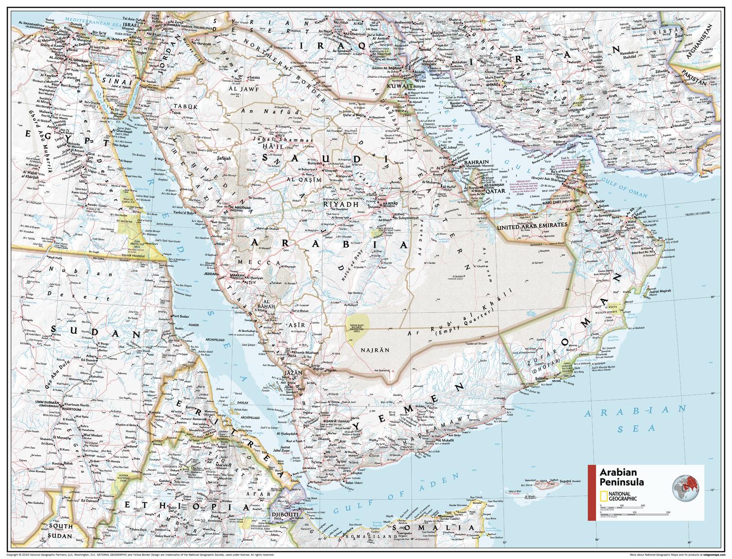
Originally featured in National Geographic’s 11th Edition Atlas of the World, the Arabian Peninsula Wall Map presents the region’s political and physical geography in vivid detail. Combining state-of-the-art cartographic techniques with over 75 years of National Geographic design heritage, it delivers accuracy, clarity, and elegance in a format suitable for classrooms, offices, libraries, or home display.
🗺️ Map Features
-
Physical & Political Detail – Countries, capitals, cities, and key borders alongside rivers, mountains, and desert regions.
-
Shaded Relief – Depicts terrain with depth and realism, providing a clear sense of elevation and landscape.
-
Bright, Readable Colour Palette – Blue oceans and soft, natural land tones for high legibility.
-
Transverse Mercator Projection – Cylindrical projection often used in nautical navigation for its ability to represent lines of constant course.
-
Educational Value – Ideal for teaching geography, environmental studies, or Middle Eastern history.
📐 Available Sizes
| Size | Dimensions |
|---|---|
| Standard | 790 mm (W) x 610 mm (H) |
| Supermap | 915 mm (W) x 1197 mm (H) |
✨ Available Finishes
| Format | Description |
|---|---|
| 🖨️ Paper (160 gsm) | Heavyweight matte-coated paper — perfect for framing under glass. |
| 🧼 Laminated (Encapsulated) | Fully sealed between two sheets of 80-micron gloss laminate. Wipe-clean, tear-resistant, and durable. |
| 🪵 Laminated with Wooden Hang Rails | Laminated map mounted with lacquered natural timber rails (top and bottom) and a hanging cord — ready to hang. |
| 🖼️ Canvas (395 gsm) | HP Professional Matte Canvas with archival pigment-based inks. Rich texture, fade-resistant, and gallery-quality. |
| 🪵 Canvas with Wooden Hang Rails | Canvas mounted with natural timber rails and a hanging cord for a timeless, ready-to-display look. |
🔨 Please allow up to 10 working days for delivery of hang-railed maps, as these are professionally mounted by our framer.
💡 Why You’ll Love This Map
✔️ Combines political boundaries with physical landforms for complete regional context
✔️ Realistic shaded relief provides a true-to-life view of the Arabian Peninsula’s landscapes
✔️ Educationally valuable — perfect for teaching and research
✔️ Two sizes and five premium finishes to suit any display
✔️ Backed by National Geographic’s cartographic accuracy and visual style
🎯 Perfect For
-
Educational Institutions – Geography, history, and environmental studies classrooms
-
Libraries & Archives – Long-term geographic reference
-
Corporate & Government Offices – Strategic and cultural reference material
-
Home Display – For travellers, historians, and map enthusiasts
🚚 Delivery
-
Paper, Laminated, Canvas: Ships within 1–2 business days
-
Hang-railed Maps (Laminated or Canvas): Ships within 10 working days (custom-mounted)
-
Packaging: Rolled in a heavy-duty postal tube for safe arrival
The Arabian Peninsula Wall Map blends beauty, precision, and educational value — a standalone cartographic work drawn from National Geographic’s acclaimed Atlas of the World.
👉 Order today for a map that will inspire, inform, and endure.
Original: $50.05
-65%$50.05
$17.52Product Information
Product Information
Shipping & Returns
Shipping & Returns
Description
🌍 Arabian Peninsula – National Geographic Wall Map
From the 11th Edition Atlas of the World | Physical & Political Features | Published 2019
Originally featured in National Geographic’s 11th Edition Atlas of the World, the Arabian Peninsula Wall Map presents the region’s political and physical geography in vivid detail. Combining state-of-the-art cartographic techniques with over 75 years of National Geographic design heritage, it delivers accuracy, clarity, and elegance in a format suitable for classrooms, offices, libraries, or home display.
🗺️ Map Features
-
Physical & Political Detail – Countries, capitals, cities, and key borders alongside rivers, mountains, and desert regions.
-
Shaded Relief – Depicts terrain with depth and realism, providing a clear sense of elevation and landscape.
-
Bright, Readable Colour Palette – Blue oceans and soft, natural land tones for high legibility.
-
Transverse Mercator Projection – Cylindrical projection often used in nautical navigation for its ability to represent lines of constant course.
-
Educational Value – Ideal for teaching geography, environmental studies, or Middle Eastern history.
📐 Available Sizes
| Size | Dimensions |
|---|---|
| Standard | 790 mm (W) x 610 mm (H) |
| Supermap | 915 mm (W) x 1197 mm (H) |
✨ Available Finishes
| Format | Description |
|---|---|
| 🖨️ Paper (160 gsm) | Heavyweight matte-coated paper — perfect for framing under glass. |
| 🧼 Laminated (Encapsulated) | Fully sealed between two sheets of 80-micron gloss laminate. Wipe-clean, tear-resistant, and durable. |
| 🪵 Laminated with Wooden Hang Rails | Laminated map mounted with lacquered natural timber rails (top and bottom) and a hanging cord — ready to hang. |
| 🖼️ Canvas (395 gsm) | HP Professional Matte Canvas with archival pigment-based inks. Rich texture, fade-resistant, and gallery-quality. |
| 🪵 Canvas with Wooden Hang Rails | Canvas mounted with natural timber rails and a hanging cord for a timeless, ready-to-display look. |
🔨 Please allow up to 10 working days for delivery of hang-railed maps, as these are professionally mounted by our framer.
💡 Why You’ll Love This Map
✔️ Combines political boundaries with physical landforms for complete regional context
✔️ Realistic shaded relief provides a true-to-life view of the Arabian Peninsula’s landscapes
✔️ Educationally valuable — perfect for teaching and research
✔️ Two sizes and five premium finishes to suit any display
✔️ Backed by National Geographic’s cartographic accuracy and visual style
🎯 Perfect For
-
Educational Institutions – Geography, history, and environmental studies classrooms
-
Libraries & Archives – Long-term geographic reference
-
Corporate & Government Offices – Strategic and cultural reference material
-
Home Display – For travellers, historians, and map enthusiasts
🚚 Delivery
-
Paper, Laminated, Canvas: Ships within 1–2 business days
-
Hang-railed Maps (Laminated or Canvas): Ships within 10 working days (custom-mounted)
-
Packaging: Rolled in a heavy-duty postal tube for safe arrival
The Arabian Peninsula Wall Map blends beauty, precision, and educational value — a standalone cartographic work drawn from National Geographic’s acclaimed Atlas of the World.
👉 Order today for a map that will inspire, inform, and endure.