Archaeology of South America - Published 1982 by National Geographic
Archaeology of South America (1982)
Publisher: National Geographic
Published: March 1982
Scale: 1 : 5,540,000
Size: 938 mm (W) × 573 mm (H)
Orientation: Landscape
Map Type: Historical & Archaeological Thematic Map
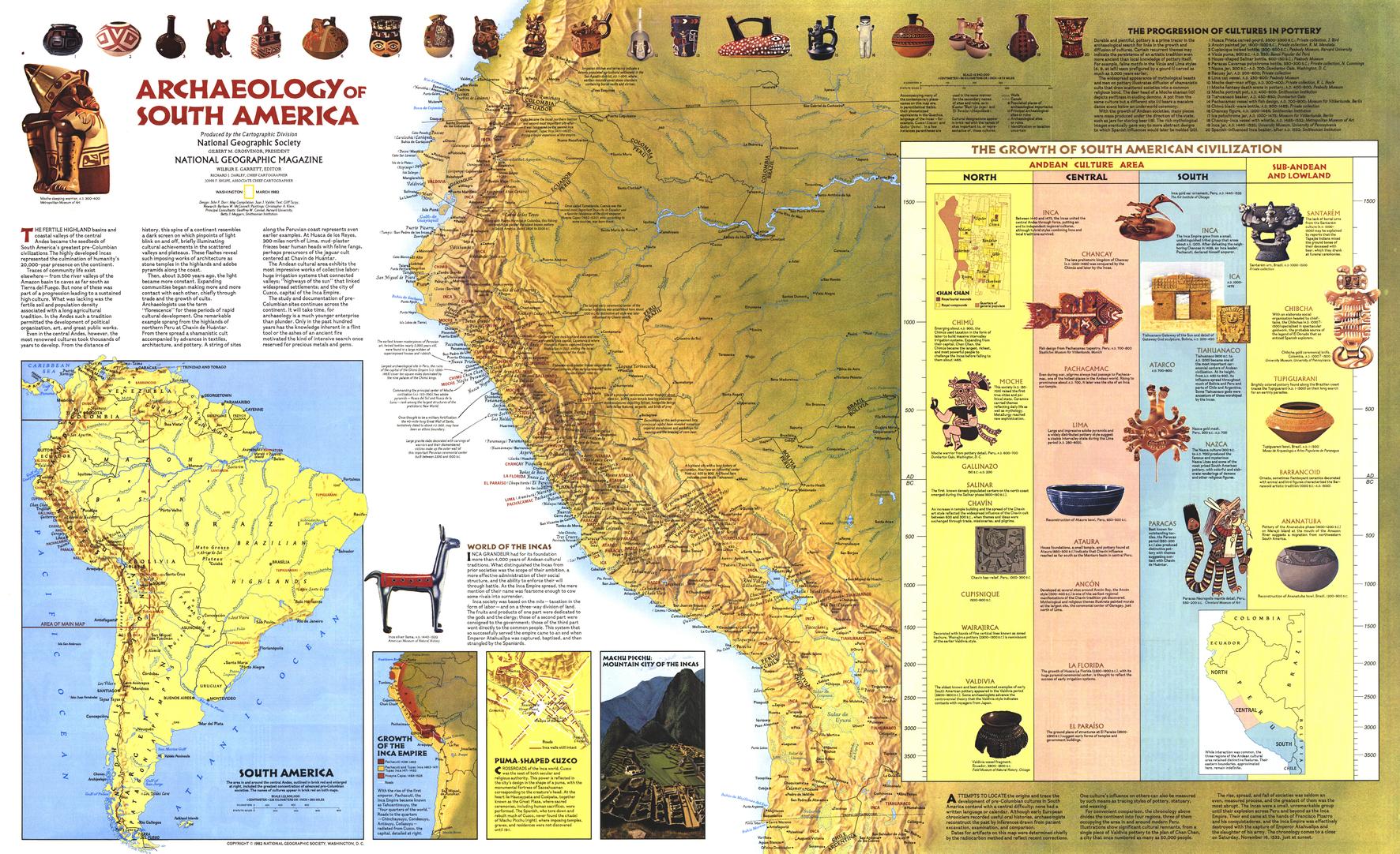
Published in 1982, Archaeology of South America is a richly illustrated thematic map that explores the deep archaeological history of the South American continent. Issued alongside the companion Indians of South America map, this sheet brings together geography, archaeology, and cultural history to reveal the locations and material legacy of South America’s great pre-Columbian civilisations.
Designed to be both informative and visually engaging, the map is filled with illustrations and explanatory notes highlighting important archaeological sites, artefacts, and cultural regions. Major centres such as Cuzco and Machu Picchu are shown in their geographic context, helping viewers understand how landscape, trade routes, and environment shaped ancient societies long before European contact.
This is classic National Geographic cartography from the early 1980s — dense with information, yet carefully balanced for clarity and exploration.
🗺️ What This Map Shows
-
Major archaeological sites across South America
-
Locations associated with ancient Andean civilisations
-
Illustrations of artefacts and material culture
-
Geographic context linking mountains, coasts, and river systems
-
Cultural regions and archaeological significance explained through notes
The map encourages close reading, rewarding curiosity with layer upon layer of historical insight.
🕰️ Understanding Ancient South America
-
Explores South America before European arrival
-
Connects archaeology with geography and environment
-
Highlights how civilisations adapted to mountains, jungles, and coasts
-
Provides context for iconic sites such as Machu Picchu within broader regional networks
This is a map that turns isolated ruins into part of a continent-wide story.
🎨 Cartography & Illustration
-
Abundant hand-drawn illustrations typical of National Geographic’s era
-
Clear symbology balanced with narrative text
-
A strong example of educational, atlas-style thematic mapping
-
Designed for study, teaching, and long-form viewing
🎨 Materials, Print Quality & Hanging Options
📄 Paper (Classic Framing Option)
-
Printed on high-quality matte paper for crisp linework and illustrations
-
Smooth, low-glare surface — ideal for framing under glass
-
A traditional choice for libraries, studies, and heritage interiors
🔒 Laminated (Write-On / Wipe-Off)
-
Printed on quality paper and encapsulated in protective laminate
-
Durable, waterproof, and tear-resistant
-
Write-on / wipe-off surface compatible with whiteboard markers and map dots
-
Ideal for education, teaching, and interactive discussion
🪵 Optional Timber Hang Rails — Laminated
-
Top and bottom natural timber rails provide structure and balance
-
Bottom rail adds weight so the wide format hangs flat and straight
-
Prevents edge curl and long-term sagging
-
Supplied with hanging cord — ready to mount on a single hook
Please allow up to 10 working days for laminated maps with hang rails.
🎨 Archival Canvas (Premium Display Option)
-
Printed on 395 gsm HP Professional Matte Canvas
-
Subtle canvas texture enhances colour depth while preserving fine illustration detail
-
Matte surface reduces reflections compared with glass-framed prints
Archival Pigment Inks
-
Produced using Hewlett-Packard archival, fade-resistant pigment inks
-
Ensures crisp typography, stable colour, and long-term durability
🪵 Optional Timber Hang Rails — Canvas
-
Top and bottom timber rails create a clean, gallery-style presentation
-
Bottom rail adds weight for a perfectly straight hang
-
Prevents edge curl and sag over time
-
Supplied with hanging cord — ready to mount
Please allow up to 10 working days for canvas maps with hang rails.
Canvas editions are intended for display and reference and are not write-on / wipe-off like laminated versions.
📐 Size & Scale
-
Size: 938 mm × 573 mm
-
Scale: 1 : 5,540,000
A generous landscape format that allows archaeological detail and illustration to be appreciated at a glance.
📊 Specifications
| Attribute | Details |
|---|---|
| Title | Archaeology of South America |
| Publisher | National Geographic |
| Year | 1982 |
| Coverage | South America |
| Map Type | Historical & archaeological thematic |
| Features | Archaeological sites, artefact illustrations, cultural notes |
| Companion Map | Indians of South America |
| Scale | 1 : 5,540,000 |
| Available Formats | Paper • Laminated • Laminated + Hang Rails • Canvas • Canvas + Hang Rails |
| Canvas Weight | 395 gsm HP Professional Matte |
| Inks (Canvas) | Hewlett-Packard archival, fade-resistant pigment inks |
| Size | 938 mm × 573 mm |
| Orientation | Landscape |
🎯 Who It’s For
-
🏺 Archaeology & ancient history enthusiasts
-
🎓 Educators & students — South American history and culture
-
🗺️ National Geographic collectors — classic 1980s thematic maps
-
🏛️ Libraries & museums — educational and cultural displays
-
🎁 Gift buyers — intellectually rich and visually engaging
🤝 Our Commitment
This historic National Geographic map is reproduced and printed in Australia with careful attention to colour accuracy and fine illustrative detail. Every print is checked and packed with care, ensuring it arrives ready to inform, inspire, and endure.
🛒 Explore South America’s ancient past — choose Paper, Laminated, or Canvas, with optional timber hang rails, and bring Archaeology of South America (1982) to your wall.
Original: $57.20
-65%$57.20
$20.02Product Information
Product Information
Shipping & Returns
Shipping & Returns
Description
Archaeology of South America (1982)
Publisher: National Geographic
Published: March 1982
Scale: 1 : 5,540,000
Size: 938 mm (W) × 573 mm (H)
Orientation: Landscape
Map Type: Historical & Archaeological Thematic Map
Published in 1982, Archaeology of South America is a richly illustrated thematic map that explores the deep archaeological history of the South American continent. Issued alongside the companion Indians of South America map, this sheet brings together geography, archaeology, and cultural history to reveal the locations and material legacy of South America’s great pre-Columbian civilisations.
Designed to be both informative and visually engaging, the map is filled with illustrations and explanatory notes highlighting important archaeological sites, artefacts, and cultural regions. Major centres such as Cuzco and Machu Picchu are shown in their geographic context, helping viewers understand how landscape, trade routes, and environment shaped ancient societies long before European contact.
This is classic National Geographic cartography from the early 1980s — dense with information, yet carefully balanced for clarity and exploration.
🗺️ What This Map Shows
-
Major archaeological sites across South America
-
Locations associated with ancient Andean civilisations
-
Illustrations of artefacts and material culture
-
Geographic context linking mountains, coasts, and river systems
-
Cultural regions and archaeological significance explained through notes
The map encourages close reading, rewarding curiosity with layer upon layer of historical insight.
🕰️ Understanding Ancient South America
-
Explores South America before European arrival
-
Connects archaeology with geography and environment
-
Highlights how civilisations adapted to mountains, jungles, and coasts
-
Provides context for iconic sites such as Machu Picchu within broader regional networks
This is a map that turns isolated ruins into part of a continent-wide story.
🎨 Cartography & Illustration
-
Abundant hand-drawn illustrations typical of National Geographic’s era
-
Clear symbology balanced with narrative text
-
A strong example of educational, atlas-style thematic mapping
-
Designed for study, teaching, and long-form viewing
🎨 Materials, Print Quality & Hanging Options
📄 Paper (Classic Framing Option)
-
Printed on high-quality matte paper for crisp linework and illustrations
-
Smooth, low-glare surface — ideal for framing under glass
-
A traditional choice for libraries, studies, and heritage interiors
🔒 Laminated (Write-On / Wipe-Off)
-
Printed on quality paper and encapsulated in protective laminate
-
Durable, waterproof, and tear-resistant
-
Write-on / wipe-off surface compatible with whiteboard markers and map dots
-
Ideal for education, teaching, and interactive discussion
🪵 Optional Timber Hang Rails — Laminated
-
Top and bottom natural timber rails provide structure and balance
-
Bottom rail adds weight so the wide format hangs flat and straight
-
Prevents edge curl and long-term sagging
-
Supplied with hanging cord — ready to mount on a single hook
Please allow up to 10 working days for laminated maps with hang rails.
🎨 Archival Canvas (Premium Display Option)
-
Printed on 395 gsm HP Professional Matte Canvas
-
Subtle canvas texture enhances colour depth while preserving fine illustration detail
-
Matte surface reduces reflections compared with glass-framed prints
Archival Pigment Inks
-
Produced using Hewlett-Packard archival, fade-resistant pigment inks
-
Ensures crisp typography, stable colour, and long-term durability
🪵 Optional Timber Hang Rails — Canvas
-
Top and bottom timber rails create a clean, gallery-style presentation
-
Bottom rail adds weight for a perfectly straight hang
-
Prevents edge curl and sag over time
-
Supplied with hanging cord — ready to mount
Please allow up to 10 working days for canvas maps with hang rails.
Canvas editions are intended for display and reference and are not write-on / wipe-off like laminated versions.
📐 Size & Scale
-
Size: 938 mm × 573 mm
-
Scale: 1 : 5,540,000
A generous landscape format that allows archaeological detail and illustration to be appreciated at a glance.
📊 Specifications
| Attribute | Details |
|---|---|
| Title | Archaeology of South America |
| Publisher | National Geographic |
| Year | 1982 |
| Coverage | South America |
| Map Type | Historical & archaeological thematic |
| Features | Archaeological sites, artefact illustrations, cultural notes |
| Companion Map | Indians of South America |
| Scale | 1 : 5,540,000 |
| Available Formats | Paper • Laminated • Laminated + Hang Rails • Canvas • Canvas + Hang Rails |
| Canvas Weight | 395 gsm HP Professional Matte |
| Inks (Canvas) | Hewlett-Packard archival, fade-resistant pigment inks |
| Size | 938 mm × 573 mm |
| Orientation | Landscape |
🎯 Who It’s For
-
🏺 Archaeology & ancient history enthusiasts
-
🎓 Educators & students — South American history and culture
-
🗺️ National Geographic collectors — classic 1980s thematic maps
-
🏛️ Libraries & museums — educational and cultural displays
-
🎁 Gift buyers — intellectually rich and visually engaging
🤝 Our Commitment
This historic National Geographic map is reproduced and printed in Australia with careful attention to colour accuracy and fine illustrative detail. Every print is checked and packed with care, ensuring it arrives ready to inform, inspire, and endure.
🛒 Explore South America’s ancient past — choose Paper, Laminated, or Canvas, with optional timber hang rails, and bring Archaeology of South America (1982) to your wall.


