Atlantic Ocean Floor Atlas of the World, 11th Edition, National Geographic Wall Map
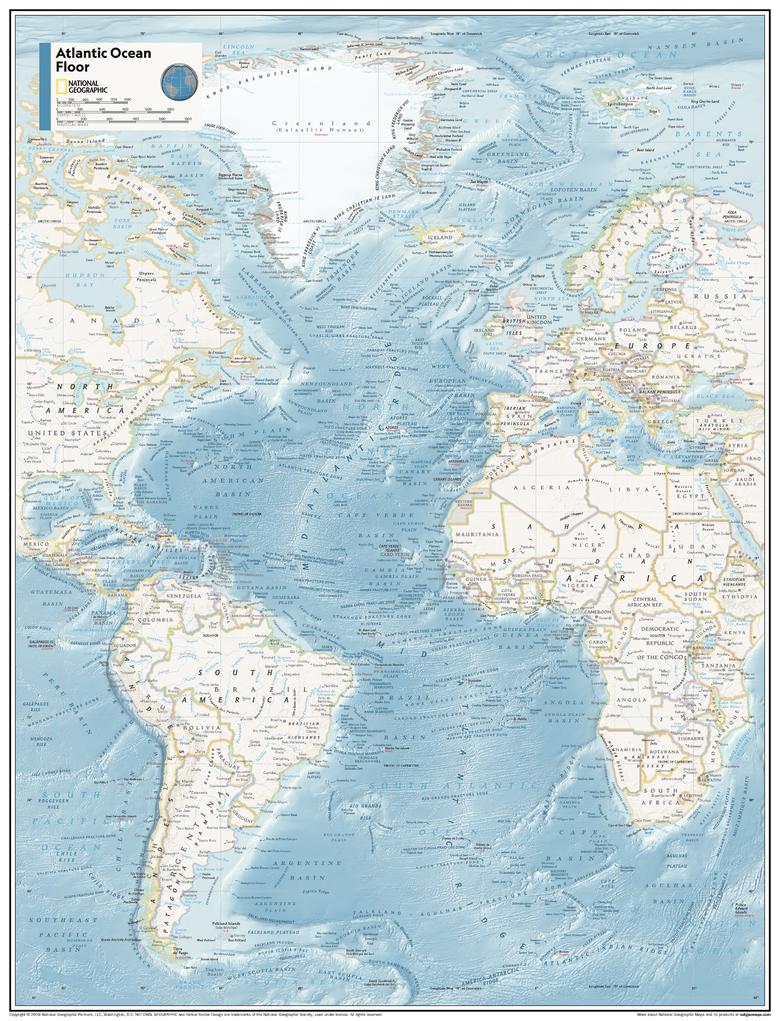
🌊 Atlantic Ocean Floor Wall Map
National Geographic – Atlas of the World, 11th Edition
A breathtaking window into the hidden topography beneath the waves
Unveil the dramatic undersea landscapes of the Atlantic with this captivating Physical Wall Map of the Atlantic Ocean Floor, as presented in National Geographic’s 11th Edition Atlas of the World. From the Mid-Atlantic Ridge to deep oceanic trenches, this map reveals a rarely seen world of mountains, canyons, fracture zones and abyssal plains in exquisite detail.
Crafted with state-of-the-art cartographic precision, this map transforms complex bathymetric data into a visually compelling, easy-to-understand format — a masterpiece of science, education, and art. It’s ideal for those who are drawn to the mysteries beneath the ocean’s surface, from oceanographers and educators to students, explorers, and maritime enthusiasts.
🌐 Key Features
-
🌍 Detailed bathymetric relief of the entire Atlantic Ocean basin
-
🧭 Mid-Atlantic Ridge, continental shelves, deep trenches, and fracture zones depicted with clarity
-
🌊 Ocean floor shading reveals depth and topography at a glance
-
🗺️ Miller Cylindrical Projection — a navigational projection preserving angular accuracy for straight rhumb lines
-
🏫 Ideal for classrooms, research institutions, maritime centres, or home libraries
Whether used as an educational resource or a statement piece, this map offers a compelling visual of one of Earth's most vital geographic regions — the mighty Atlantic and the seafloor secrets it holds.
🖼️ Premium Material Options
Choose the format that best suits your space, purpose, or decor:
| Format | Description |
|---|---|
| 📄 Paper (160 gsm) | Smooth matte finish, perfect for framing under glass |
| 💧 Laminated (Gloss) | Wipe-clean, long-lasting surface using 80-micron encapsulated gloss laminate |
| 🖼️ Canvas (395 gsm) | HP Professional Matte Canvas + pigment inks – archival quality and fade-proof |
| 🪵 Laminated + Hang Rails | Laminated map with top and bottom timber rails and cord for elegant display |
| 🪵 Canvas + Hang Rails | Canvas mounted with timber rails – a ready-to-hang, gallery-style finish |
🕰️ Please allow 10 working days for hang-railed maps – each is handcrafted by our in-house framer.
📏 Specifications
| Attribute | Details |
|---|---|
| Title | Atlantic Ocean Floor – Physical Wall Map |
| Edition | 11th Edition, Atlas of the World |
| Publisher | National Geographic |
| Map Type | Physical / Bathymetric |
| Projection | Miller Cylindrical |
| Standard Size | 790 mm (wide) × 610 mm (high) |
| Supermap Size | 915 mm (wide) × 1197 mm (high) |
| Language | English |
| Published | 2019 |
| Made in | Australia |
🌟 Why You'll Love This Map
✅ Reveal the world beneath the waves – perfect for ocean science and environmental education
✅ Designed by cartographic experts – with over 75 years of National Geographic mapmaking tradition
✅ Timeless aesthetic – pairs beautifully with both modern and classic interiors
✅ Durable, archival-quality materials – made to last for years of display and use
✅ Ideal gift for teachers, students, explorers, or ocean lovers
Let this extraordinary map transport you to the submerged mountain ranges, abyssal plains, and hidden geological wonders that stretch from the Arctic to the Southern Ocean. The Atlantic Ocean Floor Wall Map is not only a scientific reference — it’s a visual invitation to discover the dynamic underworld that shapes our planet’s continents, climate, and life.
Product Information
Product Information
Shipping & Returns
Shipping & Returns
Description
🌊 Atlantic Ocean Floor Wall Map
National Geographic – Atlas of the World, 11th Edition
A breathtaking window into the hidden topography beneath the waves
Unveil the dramatic undersea landscapes of the Atlantic with this captivating Physical Wall Map of the Atlantic Ocean Floor, as presented in National Geographic’s 11th Edition Atlas of the World. From the Mid-Atlantic Ridge to deep oceanic trenches, this map reveals a rarely seen world of mountains, canyons, fracture zones and abyssal plains in exquisite detail.
Crafted with state-of-the-art cartographic precision, this map transforms complex bathymetric data into a visually compelling, easy-to-understand format — a masterpiece of science, education, and art. It’s ideal for those who are drawn to the mysteries beneath the ocean’s surface, from oceanographers and educators to students, explorers, and maritime enthusiasts.
🌐 Key Features
-
🌍 Detailed bathymetric relief of the entire Atlantic Ocean basin
-
🧭 Mid-Atlantic Ridge, continental shelves, deep trenches, and fracture zones depicted with clarity
-
🌊 Ocean floor shading reveals depth and topography at a glance
-
🗺️ Miller Cylindrical Projection — a navigational projection preserving angular accuracy for straight rhumb lines
-
🏫 Ideal for classrooms, research institutions, maritime centres, or home libraries
Whether used as an educational resource or a statement piece, this map offers a compelling visual of one of Earth's most vital geographic regions — the mighty Atlantic and the seafloor secrets it holds.
🖼️ Premium Material Options
Choose the format that best suits your space, purpose, or decor:
| Format | Description |
|---|---|
| 📄 Paper (160 gsm) | Smooth matte finish, perfect for framing under glass |
| 💧 Laminated (Gloss) | Wipe-clean, long-lasting surface using 80-micron encapsulated gloss laminate |
| 🖼️ Canvas (395 gsm) | HP Professional Matte Canvas + pigment inks – archival quality and fade-proof |
| 🪵 Laminated + Hang Rails | Laminated map with top and bottom timber rails and cord for elegant display |
| 🪵 Canvas + Hang Rails | Canvas mounted with timber rails – a ready-to-hang, gallery-style finish |
🕰️ Please allow 10 working days for hang-railed maps – each is handcrafted by our in-house framer.
📏 Specifications
| Attribute | Details |
|---|---|
| Title | Atlantic Ocean Floor – Physical Wall Map |
| Edition | 11th Edition, Atlas of the World |
| Publisher | National Geographic |
| Map Type | Physical / Bathymetric |
| Projection | Miller Cylindrical |
| Standard Size | 790 mm (wide) × 610 mm (high) |
| Supermap Size | 915 mm (wide) × 1197 mm (high) |
| Language | English |
| Published | 2019 |
| Made in | Australia |
🌟 Why You'll Love This Map
✅ Reveal the world beneath the waves – perfect for ocean science and environmental education
✅ Designed by cartographic experts – with over 75 years of National Geographic mapmaking tradition
✅ Timeless aesthetic – pairs beautifully with both modern and classic interiors
✅ Durable, archival-quality materials – made to last for years of display and use
✅ Ideal gift for teachers, students, explorers, or ocean lovers
Let this extraordinary map transport you to the submerged mountain ranges, abyssal plains, and hidden geological wonders that stretch from the Arctic to the Southern Ocean. The Atlantic Ocean Floor Wall Map is not only a scientific reference — it’s a visual invitation to discover the dynamic underworld that shapes our planet’s continents, climate, and life.


