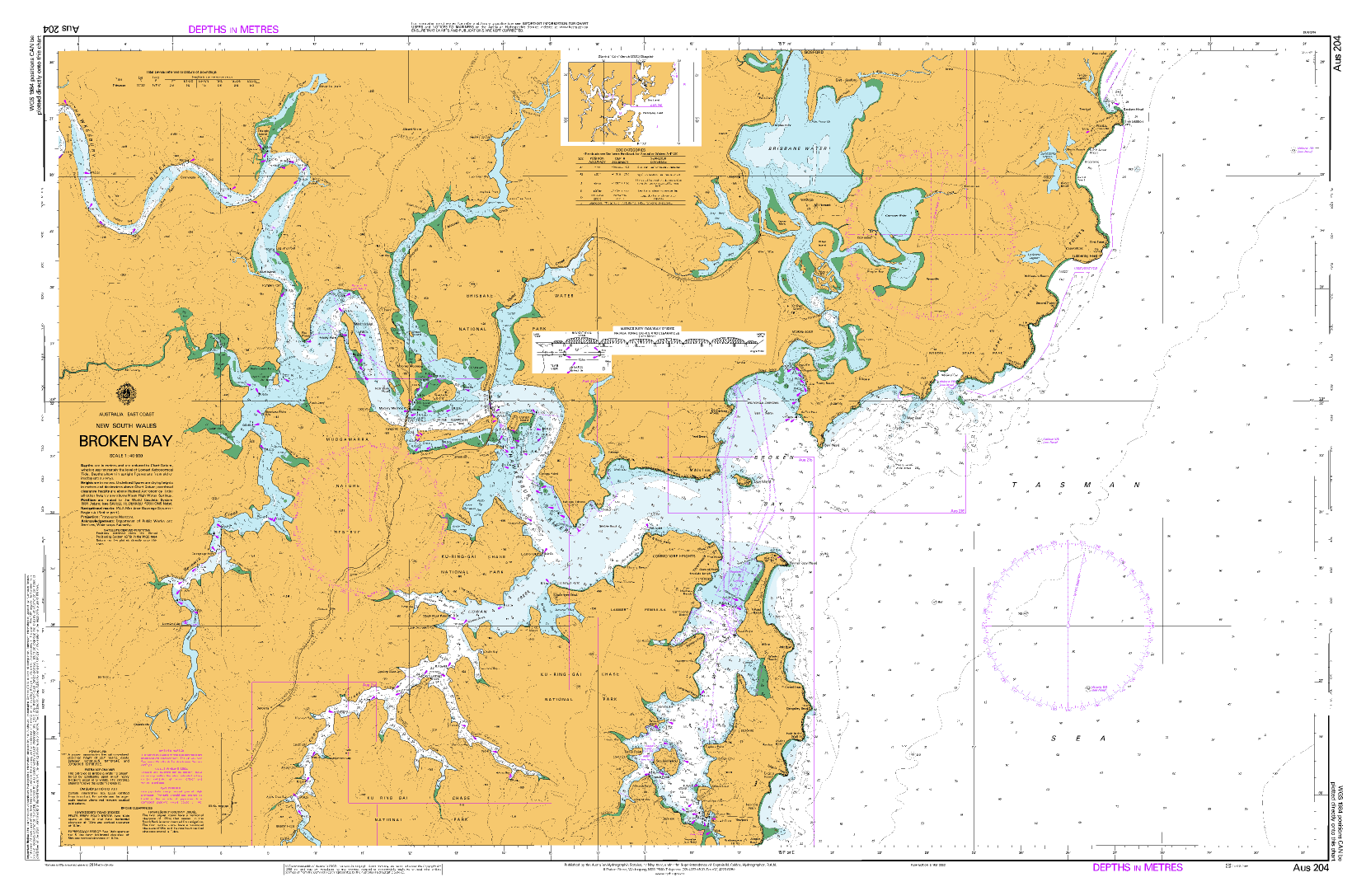
AUS 204 — Broken Bay, NSW Nautical Chart
For skippers, fishers, and coastal cruisers working Broken Bay, the Hawkesbury approaches, and offshore leads
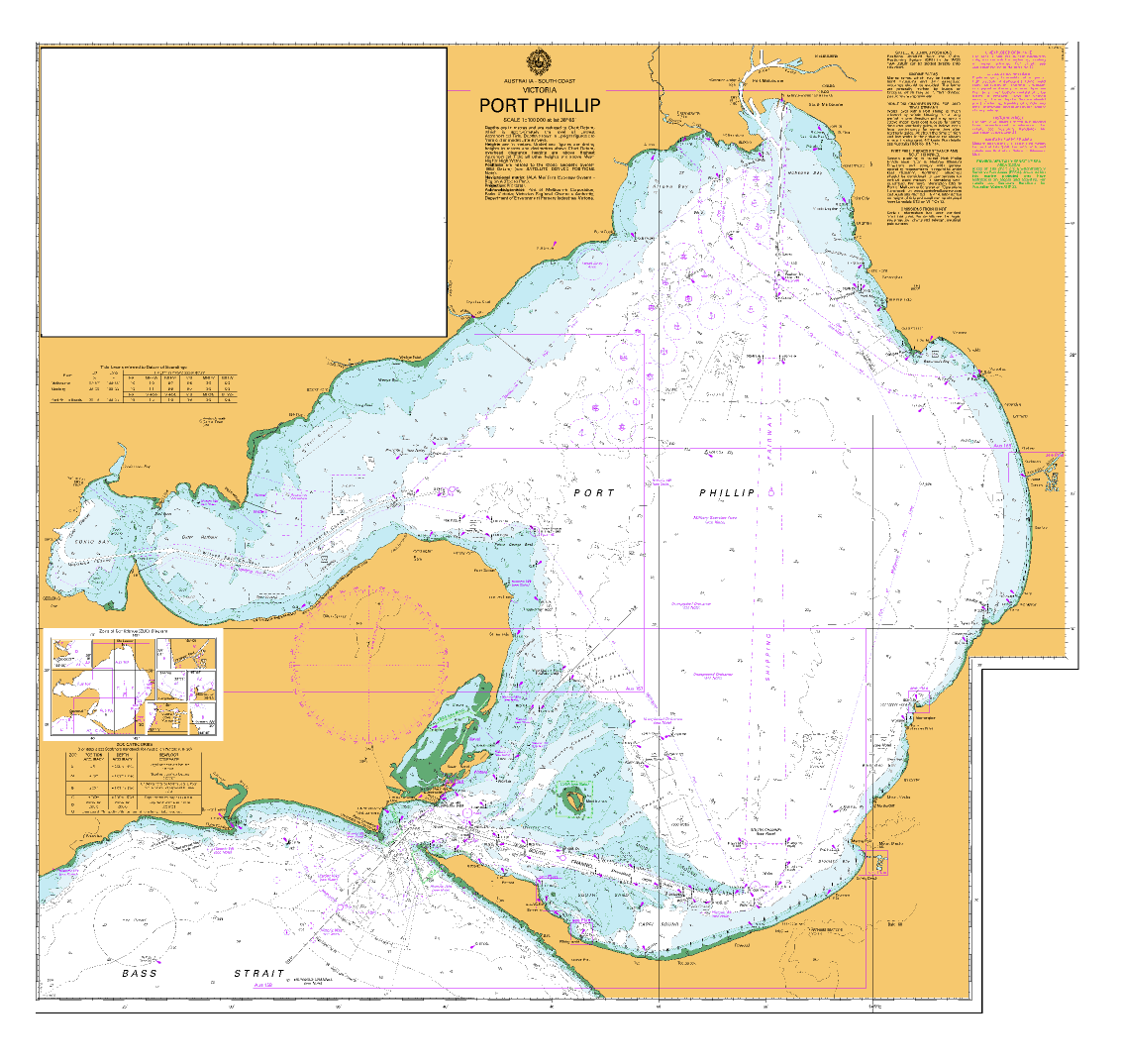
Bring Broken Bay into crisp, working focus. AUS 204 provides broad harbour and approach coverage at 1:40,000—ideal for plotting entries, marking pilotage cues, and running clear crew briefings across the bay and river mouths.
Why skippers choose this chart
-
🧭 Approach-ready scale — 1:40,000 balances coastal context with inshore detail.
-
⚓ Harbour & river junctions — Clear depiction of bay entrances and river mouths for safe set-piece approaches.
-
🛰️ UTM projection — Universal Transverse Mercator for clean bearings and GPS plotting.
-
📍 Exact bounds listed — Quick position checks with North/South/East/West limits.
-
🗺️ Deck-ready materials — Soft-matte, writeable laminate face for chart-correction/grease pencils.
-
🇦🇺 Printed in Australia — Colour-managed, hand-checked output.
Coverage
-
Chart — AUS 204: Australia · East Coast · New South Wales · Broken Bay
-
Scale: 1:40,000 · Projection: Universal Transverse Mercator
-
Bounds: N 33°25.77′ S · S 33°39.91′ S · E 151°31.23′ E · W 151°04.57′ E
-
Publication: 17-May-1977 · Latest Edition: 13-Sep-2024
-
Premium materials & finishes
-
Paper (120 gsm matte) — Clear, lightweight, and chart-table friendly; perfect under nav-station glass.
-
Laminated (soft-matte front / gloss back, edge-sealed) — Front is low-glare and writeable; gloss back adds rigidity. Wipes clean with a soft cloth.
The soft-matte face is specified so you can mark fixes, ETAs, and pilotage notes, then clean down between passages.
On-board & ashore use
-
🧭 Passage planning — Plot approach waypoints and contingencies before you cast off.
-
📒 Crew briefings — At-a-glance layout for roles, calls, and nav references.
-
🛠️ Club/office display — Durable laminated option for training rooms and noticeboards.
-
🎁 Practical gift — A dependable working chart for local and visiting skippers.
Specifications
| Field | Detail |
|---|---|
| Chart Number | AUS 204 |
| Title | Australia — East Coast — New South Wales — Broken Bay |
| Geographic Location | Australia |
| Scale | 1:40,000 |
| Projection | Universal Transverse Mercator |
| North / South Limits | 33°25.77′ S / 33°39.91′ S |
| East / West Limits | 151°31.23′ E / 151°04.57′ E |
| Publication Date | 17-May-1977 |
| Latest Edition | 13-Sep-2024 |
| Sheet Size | 1100 mm (W) × 770 mm (H) |
| Available Finishes | Paper (120 gsm matte); Laminated (soft-matte writeable front, gloss back, edge-sealed) |
| Inks | Pigment-based, fade-resistant |
| Origin | Printed in Australia |
Important note (mariner’s guidance)
Ideal for planning, briefing, education, and display. For navigation underway, always use the latest official hydrographic chart or approved ECDIS together with current Notices to Mariners and local guidance. Conditions and aids can change.
Line up for Broken Bay with confidence
Choose your finish above and add to cart — locally printed, hand-checked, and shipped with care.