Australia and Oceania Political & Physical Continent Map with Country Flags
Dual-View Reference | 14 National Flags | Large Wall Format (1000 × 547 mm) | Premium Finishes
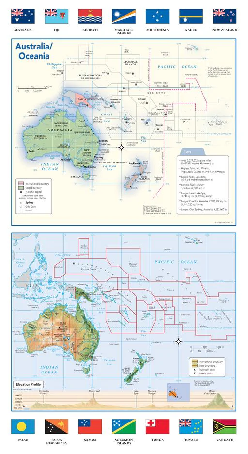
A refined, large-format wall map that brings Australia and Oceania into clear focus—combining political structure, physical geography, and national identity in one cohesive and visually engaging design.
Published by Globe Turner, this edition pairs a detailed political map with a vibrant physical map, while also featuring all 14 national flags of the countries that make up the region. From continental Australia to the island nations of the Pacific, it offers a complete and accessible overview of one of the world’s most geographically unique regions.
At one metre tall, this is a map designed to educate, inform, and elevate any wall space.
Why This Map Stands Out
Three perspectives in one
Political boundaries, physical terrain, and national flags combine to create a complete regional view.
All 14 national flags included
Adds cultural context and identity—ideal for classrooms and global awareness.
Clarity across a dispersed region
Designed to make sense of Australia and the vast island networks of Oceania.
Educational depth built in
Includes a fact panel and elevation profile for quick learning and reference.
Clean, balanced cartography
Easy to read while remaining visually appealing—perfect for both study and display.
🗺️ What the Map Shows
- A full political map of Australia and Oceania with countries, territories, capitals, and major cities clearly labelled
- A detailed physical map showing mountain ranges, deserts, islands, reefs, and elevation zones
- Major geographic features including the Great Dividing Range and New Zealand’s Southern Alps
- The broader Pacific Ocean context, connecting island nations across the region
- A cross-continent elevation profile illustrating terrain variation
- A fact panel with key insights about Australia and Oceania
- All 14 national flags, clearly displayed for reference and learning
📐 Size & Format
1000 mm (H) × 547 mm (W)
Portrait orientation
A tall, space-efficient format ideal for:
- Classrooms and educational displays
- Offices and study areas
- Libraries and learning environments
- Narrow wall spaces needing vertical emphasis
✨ Premium Finishes
| Format | Description |
|---|---|
| 📜 Paper (160 gsm) | Heavyweight matte-coated paper—ideal for framing. Crisp detail with a low-glare finish. |
| 🧼 Laminated (Encapsulated) | Sealed in 2 × 80-micron gloss laminate. Durable, wipe-clean, and perfect for interactive use. |
| 🪵 Laminated + Timber Hang Rails | Laminated map mounted with lacquered natural timber rails and hanging cord—ready to display. |
| 🖼️ Canvas (395 gsm HP Professional Matte) | Printed with archival pigment inks. Rich texture and gallery-quality presentation. |
| 🪵 Canvas + Timber Hang Rails | Canvas paired with timber rails for a refined, frame-free display solution. |
🔨 Please allow up to 10 working days for professionally mounted hang-railed finishes.
📊 Specifications
| Feature | Detail |
|---|---|
| Title | Australia & Oceania — Political & Physical Continent Map with Country Flags |
| Publisher | Globe Turner |
| Published | 2019 |
| Dimensions | 1000 mm (H) × 547 mm (W) |
| Orientation | Portrait |
| Map Type | Political & Physical (Dual Map with Flags) |
| Features | Countries, cities, terrain, elevation profile, fact panel, 14 national flags |
| Materials | 160 gsm matte paper / 2 × 80-micron laminate / 395 gsm HP Professional Matte Canvas |
| Printing | Pigment-based, fade-resistant inks |
| Origin | Printed in Australia |
🎯 Ideal For
- Educators and students studying Australia, Oceania, and Pacific geography
- Classrooms and educational institutions
- Offices needing a clear regional reference map
- Travellers and geography enthusiasts
- Gift buyers seeking an educational and visually engaging wall map
🌏 A Region of Ocean and Connection
Australia and Oceania is defined by its scale and separation:
- A vast continental landmass alongside scattered island nations
- Diverse environments—from deserts and alpine regions to coral reefs and tropical islands
- Countries connected not by land, but by the Pacific Ocean
This map reveals those relationships—showing how geography, distance, and identity intersect across the region.
🤝 Our Commitment
- Printed in Australia using archival-quality production
- Premium materials selected for clarity and durability
- Colour-managed for consistent readability
- Each map is hand-checked before dispatch
- Carefully packaged for safe delivery
🚚 Delivery
- Paper, Laminated, Canvas (rolled): Dispatch within 1–2 business days
- Hang-Railed Maps: Made to order—allow up to 10 working days
- Packaging: Securely rolled in protective tubing
A region brought together—politically, physically, and culturally.
👉 Order now and explore Australia and Oceania in one complete, beautifully designed map.
Original: $57.20
-65%$57.20
$20.02Product Information
Product Information
Shipping & Returns
Shipping & Returns
Description
Dual-View Reference | 14 National Flags | Large Wall Format (1000 × 547 mm) | Premium Finishes
A refined, large-format wall map that brings Australia and Oceania into clear focus—combining political structure, physical geography, and national identity in one cohesive and visually engaging design.
Published by Globe Turner, this edition pairs a detailed political map with a vibrant physical map, while also featuring all 14 national flags of the countries that make up the region. From continental Australia to the island nations of the Pacific, it offers a complete and accessible overview of one of the world’s most geographically unique regions.
At one metre tall, this is a map designed to educate, inform, and elevate any wall space.
Why This Map Stands Out
Three perspectives in one
Political boundaries, physical terrain, and national flags combine to create a complete regional view.
All 14 national flags included
Adds cultural context and identity—ideal for classrooms and global awareness.
Clarity across a dispersed region
Designed to make sense of Australia and the vast island networks of Oceania.
Educational depth built in
Includes a fact panel and elevation profile for quick learning and reference.
Clean, balanced cartography
Easy to read while remaining visually appealing—perfect for both study and display.
🗺️ What the Map Shows
- A full political map of Australia and Oceania with countries, territories, capitals, and major cities clearly labelled
- A detailed physical map showing mountain ranges, deserts, islands, reefs, and elevation zones
- Major geographic features including the Great Dividing Range and New Zealand’s Southern Alps
- The broader Pacific Ocean context, connecting island nations across the region
- A cross-continent elevation profile illustrating terrain variation
- A fact panel with key insights about Australia and Oceania
- All 14 national flags, clearly displayed for reference and learning
📐 Size & Format
1000 mm (H) × 547 mm (W)
Portrait orientation
A tall, space-efficient format ideal for:
- Classrooms and educational displays
- Offices and study areas
- Libraries and learning environments
- Narrow wall spaces needing vertical emphasis
✨ Premium Finishes
| Format | Description |
|---|---|
| 📜 Paper (160 gsm) | Heavyweight matte-coated paper—ideal for framing. Crisp detail with a low-glare finish. |
| 🧼 Laminated (Encapsulated) | Sealed in 2 × 80-micron gloss laminate. Durable, wipe-clean, and perfect for interactive use. |
| 🪵 Laminated + Timber Hang Rails | Laminated map mounted with lacquered natural timber rails and hanging cord—ready to display. |
| 🖼️ Canvas (395 gsm HP Professional Matte) | Printed with archival pigment inks. Rich texture and gallery-quality presentation. |
| 🪵 Canvas + Timber Hang Rails | Canvas paired with timber rails for a refined, frame-free display solution. |
🔨 Please allow up to 10 working days for professionally mounted hang-railed finishes.
📊 Specifications
| Feature | Detail |
|---|---|
| Title | Australia & Oceania — Political & Physical Continent Map with Country Flags |
| Publisher | Globe Turner |
| Published | 2019 |
| Dimensions | 1000 mm (H) × 547 mm (W) |
| Orientation | Portrait |
| Map Type | Political & Physical (Dual Map with Flags) |
| Features | Countries, cities, terrain, elevation profile, fact panel, 14 national flags |
| Materials | 160 gsm matte paper / 2 × 80-micron laminate / 395 gsm HP Professional Matte Canvas |
| Printing | Pigment-based, fade-resistant inks |
| Origin | Printed in Australia |
🎯 Ideal For
- Educators and students studying Australia, Oceania, and Pacific geography
- Classrooms and educational institutions
- Offices needing a clear regional reference map
- Travellers and geography enthusiasts
- Gift buyers seeking an educational and visually engaging wall map
🌏 A Region of Ocean and Connection
Australia and Oceania is defined by its scale and separation:
- A vast continental landmass alongside scattered island nations
- Diverse environments—from deserts and alpine regions to coral reefs and tropical islands
- Countries connected not by land, but by the Pacific Ocean
This map reveals those relationships—showing how geography, distance, and identity intersect across the region.
🤝 Our Commitment
- Printed in Australia using archival-quality production
- Premium materials selected for clarity and durability
- Colour-managed for consistent readability
- Each map is hand-checked before dispatch
- Carefully packaged for safe delivery
🚚 Delivery
- Paper, Laminated, Canvas (rolled): Dispatch within 1–2 business days
- Hang-Railed Maps: Made to order—allow up to 10 working days
- Packaging: Securely rolled in protective tubing
A region brought together—politically, physically, and culturally.
👉 Order now and explore Australia and Oceania in one complete, beautifully designed map.


