Australian Operating Mines Wall Map 2025
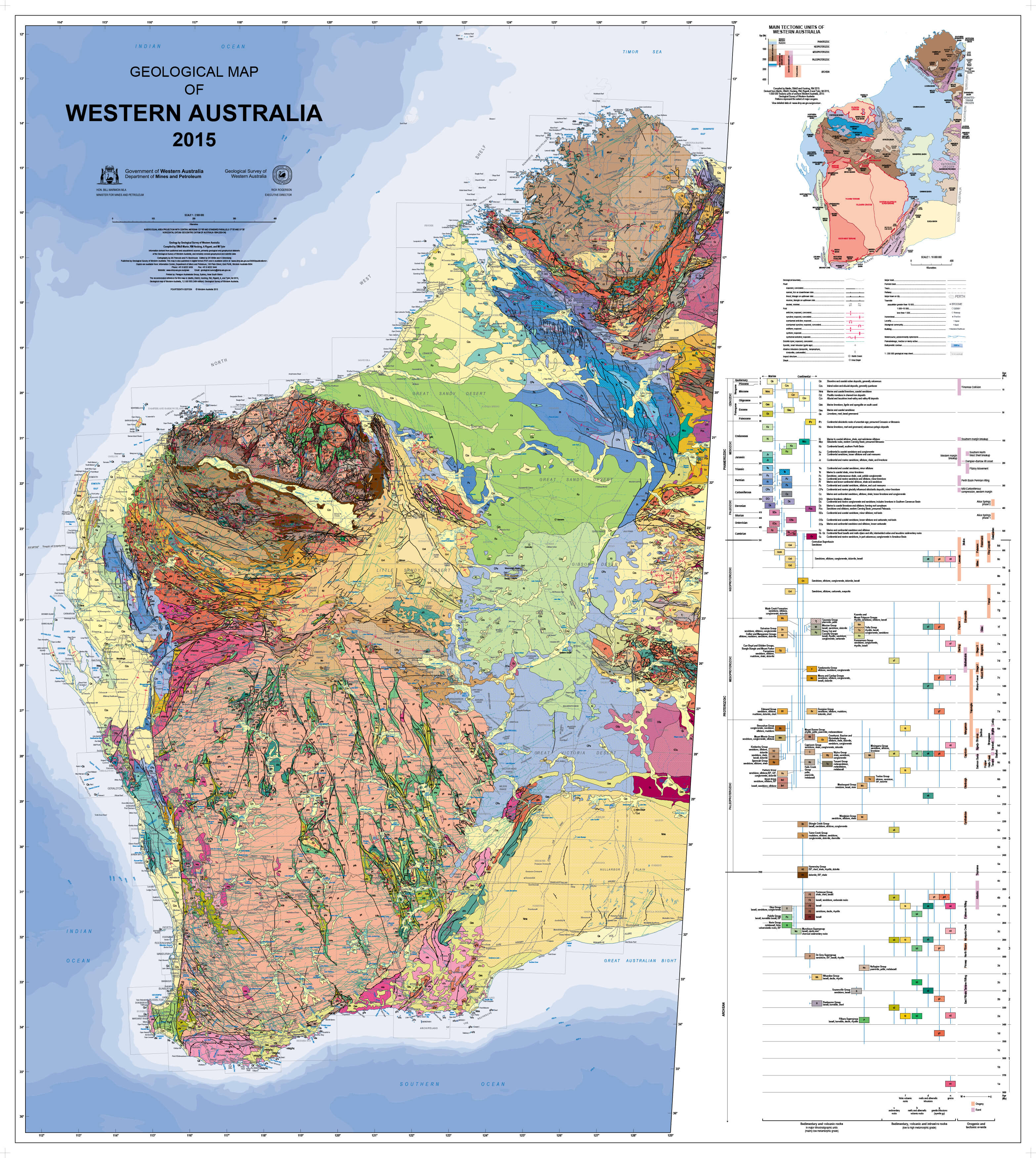
Australia — Operating Mines & Energy Infrastructure (2025)
National Wall Map • Large / Supermap / Megamap • Paper / Laminated / Laminated + Hang Rails / Canvas / Canvas + Hang Rails • Printed in Australia
At a Glance (What’s on the Map)
-
⚒️ Mines by status: operating (end-2024), developing (site works/approvals), and care & maintenance (JORC resource retained)
-
🪨 Commodities legend: from iron ore and lithium to coal, gold, rare earths, and uranium
-
🔌 Energy layer: oil & gas deposits, operating gas fields, pipeline networks
-
🚢 Export context: LNG plants, bulk ports, and supply-chain hubs along the coast
-
🚆 Infrastructure backdrop: roads and rail for haulage, logistics and market access
-
🗺️ Inset zooms: Pilbara, Bowen Basin, Olympic Dam, Hunter Valley and other high-density belts
Why This Map Works
-
📊 Decision-ready clarity — crisp symbols and colour-coded commodities for quick recognition
-
🕒 Current to January 2026 — captures Australia’s live mining landscape at the close of the year
-
🌏 Integrated energy & mining view — resources, hydrocarbons, and pipelines together on one sheet
-
🗂️ Inset focus areas — detailed panels avoid clutter while showing complex regions at scale
-
💬 Engagement piece — from boardroom to classroom, this is a map that invites conversation
Coverage & Insets
Examples of regional clarity provided on this edition:
-
Western Australia — Pilbara (iron ore, lithium corridors, major ports), Goldfields–Esperance (Au, Ni), Kimberley mineral sands and base metals
-
Queensland — Bowen & Galilee coal provinces, Mt Isa/Cloncurry copper and lead-zinc, Surat Basin gas with pipeline tie-ins to Gladstone LNG
-
NSW, VIC & TAS — Hunter coalfields, Broken Hill Pb–Zn–Ag, Bass Strait oil & gas, mineral sands provinces
🪧 Symbology & Labelling
-
🔷 Points: distinct shapes for operating, developing, and C&M sites
-
🎨 Commodity colours: matched to legend, consistent across sheet and insets
-
🛢️ Energy symbols: gas fields, oil deposits, pipeline corridors with status line styles
-
🏷️ Label hierarchy: mine name → commodity → operator/region (where space allows); key ports and LNG plants in bold
Finishes & Display Options
-
📄 Paper (160 gsm Matte-Coated) — smooth, low-glare, ideal for framing under glass
-
💧 Laminated (True Encapsulation, 2 × 80-micron gloss) — waterproof, tear-resistant, wipe-clean; mark-up with non-permanent whiteboard pens
-
🪵 Laminated + Timber Hang Rails — natural lacquered rails (top & bottom) + hanging cord; allow up to 10 working days
-
🖼️ Canvas (HP 395 gsm Professional Matte) — gallery-grade canvas with HP pigment inks for durability and fade resistance
-
🪵 Canvas + Timber Hang Rails — same premium canvas, finished with rails, ready to hang; allow up to 10 working days
Sizes
-
Large: 1182 mm (W) × 840 mm (H)
-
Supermap: 1450 mm (W) × 1030 mm (H)
-
Megamap: 2000mm (W) × 1415 mm (H)
📏 All editions designed to be wall-readable from 2–3 metres — perfect for meeting rooms and teaching spaces.
Specifications
| Field | Details |
|---|---|
| Title | Australian Operating Mines Wall Map (2025) |
| Status Cut-off | January 2026 (Operating / Developing / Care & Maintenance) |
| Energy Layer | Oil & gas deposits, operating gas fields, pipelines |
| Commodities | Base metals, Battery/alloy metals, Bauxite, Coal, Diamond, Fertiliser, Graphite, HMS, Iron ore, Lithium, Other metals, Precious metals, Rare earths, Uranium |
| Insets | Pilbara, Bowen Basin, Olympic Dam, Hunter Valley + others |
| Formats | Paper • Laminated • Laminated + Hang Rails • Canvas • Canvas + Hang Rails |
| Paper | 160 gsm matte-coated |
| Laminate | 2 × 80-micron gloss (true encapsulation) |
| Canvas | HP 395 gsm Professional Matte |
| Inks | HP pigment-based, fade-resistant |
| Origin | Printed in Australia |
How Teams Use It
-
🏭 Executive strategy: align boards, partners, and investors with one clear picture
-
🚚 Ops & logistics: haulage, port, and pipeline planning
-
🎓 Education: teach resource geography, geology, and hydrocarbon systems
-
🤝 Stakeholder engagement: wall-ready for foyers, booths, and reception areas
Our Commitment
-
🇦🇺 Local production — printed and finished in Australia
-
🌱 Sustainability — FSC® papers + long-life pigment inks
-
✔️ Quality assurance — hand-checked for clarity, colour, and finish
-
📦 Packed with care — rolled, boxed, and shipped securely
Australia’s resource landscape at a glance.
Select your size and finish, and we’ll deliver a boardroom-ready map you’ll rely on for years.
Original: $128.75
-65%$128.75
$45.06Product Information
Product Information
Shipping & Returns
Shipping & Returns
Description
Australia — Operating Mines & Energy Infrastructure (2025)
National Wall Map • Large / Supermap / Megamap • Paper / Laminated / Laminated + Hang Rails / Canvas / Canvas + Hang Rails • Printed in Australia
At a Glance (What’s on the Map)
-
⚒️ Mines by status: operating (end-2024), developing (site works/approvals), and care & maintenance (JORC resource retained)
-
🪨 Commodities legend: from iron ore and lithium to coal, gold, rare earths, and uranium
-
🔌 Energy layer: oil & gas deposits, operating gas fields, pipeline networks
-
🚢 Export context: LNG plants, bulk ports, and supply-chain hubs along the coast
-
🚆 Infrastructure backdrop: roads and rail for haulage, logistics and market access
-
🗺️ Inset zooms: Pilbara, Bowen Basin, Olympic Dam, Hunter Valley and other high-density belts
Why This Map Works
-
📊 Decision-ready clarity — crisp symbols and colour-coded commodities for quick recognition
-
🕒 Current to January 2026 — captures Australia’s live mining landscape at the close of the year
-
🌏 Integrated energy & mining view — resources, hydrocarbons, and pipelines together on one sheet
-
🗂️ Inset focus areas — detailed panels avoid clutter while showing complex regions at scale
-
💬 Engagement piece — from boardroom to classroom, this is a map that invites conversation
Coverage & Insets
Examples of regional clarity provided on this edition:
-
Western Australia — Pilbara (iron ore, lithium corridors, major ports), Goldfields–Esperance (Au, Ni), Kimberley mineral sands and base metals
-
Queensland — Bowen & Galilee coal provinces, Mt Isa/Cloncurry copper and lead-zinc, Surat Basin gas with pipeline tie-ins to Gladstone LNG
-
NSW, VIC & TAS — Hunter coalfields, Broken Hill Pb–Zn–Ag, Bass Strait oil & gas, mineral sands provinces
🪧 Symbology & Labelling
-
🔷 Points: distinct shapes for operating, developing, and C&M sites
-
🎨 Commodity colours: matched to legend, consistent across sheet and insets
-
🛢️ Energy symbols: gas fields, oil deposits, pipeline corridors with status line styles
-
🏷️ Label hierarchy: mine name → commodity → operator/region (where space allows); key ports and LNG plants in bold
Finishes & Display Options
-
📄 Paper (160 gsm Matte-Coated) — smooth, low-glare, ideal for framing under glass
-
💧 Laminated (True Encapsulation, 2 × 80-micron gloss) — waterproof, tear-resistant, wipe-clean; mark-up with non-permanent whiteboard pens
-
🪵 Laminated + Timber Hang Rails — natural lacquered rails (top & bottom) + hanging cord; allow up to 10 working days
-
🖼️ Canvas (HP 395 gsm Professional Matte) — gallery-grade canvas with HP pigment inks for durability and fade resistance
-
🪵 Canvas + Timber Hang Rails — same premium canvas, finished with rails, ready to hang; allow up to 10 working days
Sizes
-
Large: 1182 mm (W) × 840 mm (H)
-
Supermap: 1450 mm (W) × 1030 mm (H)
-
Megamap: 2000mm (W) × 1415 mm (H)
📏 All editions designed to be wall-readable from 2–3 metres — perfect for meeting rooms and teaching spaces.
Specifications
| Field | Details |
|---|---|
| Title | Australian Operating Mines Wall Map (2025) |
| Status Cut-off | January 2026 (Operating / Developing / Care & Maintenance) |
| Energy Layer | Oil & gas deposits, operating gas fields, pipelines |
| Commodities | Base metals, Battery/alloy metals, Bauxite, Coal, Diamond, Fertiliser, Graphite, HMS, Iron ore, Lithium, Other metals, Precious metals, Rare earths, Uranium |
| Insets | Pilbara, Bowen Basin, Olympic Dam, Hunter Valley + others |
| Formats | Paper • Laminated • Laminated + Hang Rails • Canvas • Canvas + Hang Rails |
| Paper | 160 gsm matte-coated |
| Laminate | 2 × 80-micron gloss (true encapsulation) |
| Canvas | HP 395 gsm Professional Matte |
| Inks | HP pigment-based, fade-resistant |
| Origin | Printed in Australia |
How Teams Use It
-
🏭 Executive strategy: align boards, partners, and investors with one clear picture
-
🚚 Ops & logistics: haulage, port, and pipeline planning
-
🎓 Education: teach resource geography, geology, and hydrocarbon systems
-
🤝 Stakeholder engagement: wall-ready for foyers, booths, and reception areas
Our Commitment
-
🇦🇺 Local production — printed and finished in Australia
-
🌱 Sustainability — FSC® papers + long-life pigment inks
-
✔️ Quality assurance — hand-checked for clarity, colour, and finish
-
📦 Packed with care — rolled, boxed, and shipped securely
Australia’s resource landscape at a glance.
Select your size and finish, and we’ll deliver a boardroom-ready map you’ll rely on for years.