Baltic States Wall Map 864 x 1118mm
Physical & Political Detail | Shaded Relief | Premium Finishes
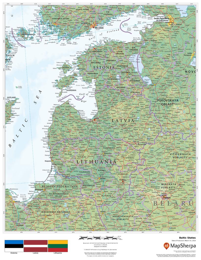
Explore Estonia, Latvia, and Lithuania in striking clarity. This wall map blends physical geography and political boundaries, using colour-by-elevation and refined relief shading to reveal the Baltic region’s coastlines, plains, lakes, and uplands—alongside clear borders, regions, cities, roads, and waterways. A refined, informative centerpiece for homes, offices, classrooms, and libraries.
🗺️ Features & Highlights
-
Three Countries, One View: Comprehensive coverage of Estonia, Latvia, and Lithuania, with useful context for Poland, Belarus, Russia (Kaliningrad & west), Scandinavia, and the Baltic Sea.
-
Physical + Political Clarity: Terrain shading, elevation colouring, and clearly delineated boundaries make orientation effortless.
-
Coast & Inland Detail: Major ports, rivers, lakes, national parks, and key transport corridors are easy to read at wall distance.
-
Elegant Cartography: Clean fonts and balanced symbology for a display that’s both decorative and practical.
✨ Available Finishes
| Format | Description |
|---|---|
| 📜 Paper (160 gsm) | Heavyweight matte-coated paper—perfect for framing under glass. |
| 🧼 Laminated (Encapsulated) | Fully sealed in 80-micron gloss laminate for a durable, wipe-clean surface—ideal for classrooms and busy offices. |
| 🪵 Laminated with Wooden Hang Rails | Laminated map mounted with lacquered natural timber rails (top & bottom) and a hanging cord—arrives ready to display. |
| 🖼️ Canvas (395 gsm) | HP Professional Matte Canvas with archival pigment inks—rich texture, fade-resistant, gallery quality. |
| 🪵 Canvas with Wooden Hang Rails | Canvas mounted with timber rails and hanging cord—timeless, ready-to-hang finish (no frame required). |
🔨 Note: Hang-railed maps are custom mounted—please allow up to 10 working days.
📐 Specifications
| Feature | Detail |
|---|---|
| Title | Baltic States Wall Map |
| Countries | Estonia, Latvia, Lithuania |
| Map Type | Physical & Political |
| Scale | 1:1,800,000 |
| Dimensions | 864 mm (W) × 1118 mm (H) |
| Materials | Paper, Laminated, Canvas; with/without Rails |
| Printing | Pigment-based, fade-resistant inks |
🎁 Perfect For
-
Education & Research: Clear reference for European studies and regional geography.
-
Home & Office Décor: Sophisticated wall statement with everyday utility.
-
Planning & Travel: Visualize cross-border routes, coastal links, and regional context.
-
Institutions & Libraries: Durable finishes built for frequent use.
🚚 Delivery
-
Paper, Laminated, Canvas (rolled): Typically ship within 1–2 business days.
-
Hang-Railed Maps: Made to order—please allow up to 10 working days.
-
Protective Packaging: Securely packed to arrive in pristine condition.
Bring the Baltic region into clear focus—choose your finish and add to cart today.
Product Information
Product Information
Shipping & Returns
Shipping & Returns
Description
Physical & Political Detail | Shaded Relief | Premium Finishes
Explore Estonia, Latvia, and Lithuania in striking clarity. This wall map blends physical geography and political boundaries, using colour-by-elevation and refined relief shading to reveal the Baltic region’s coastlines, plains, lakes, and uplands—alongside clear borders, regions, cities, roads, and waterways. A refined, informative centerpiece for homes, offices, classrooms, and libraries.
🗺️ Features & Highlights
-
Three Countries, One View: Comprehensive coverage of Estonia, Latvia, and Lithuania, with useful context for Poland, Belarus, Russia (Kaliningrad & west), Scandinavia, and the Baltic Sea.
-
Physical + Political Clarity: Terrain shading, elevation colouring, and clearly delineated boundaries make orientation effortless.
-
Coast & Inland Detail: Major ports, rivers, lakes, national parks, and key transport corridors are easy to read at wall distance.
-
Elegant Cartography: Clean fonts and balanced symbology for a display that’s both decorative and practical.
✨ Available Finishes
| Format | Description |
|---|---|
| 📜 Paper (160 gsm) | Heavyweight matte-coated paper—perfect for framing under glass. |
| 🧼 Laminated (Encapsulated) | Fully sealed in 80-micron gloss laminate for a durable, wipe-clean surface—ideal for classrooms and busy offices. |
| 🪵 Laminated with Wooden Hang Rails | Laminated map mounted with lacquered natural timber rails (top & bottom) and a hanging cord—arrives ready to display. |
| 🖼️ Canvas (395 gsm) | HP Professional Matte Canvas with archival pigment inks—rich texture, fade-resistant, gallery quality. |
| 🪵 Canvas with Wooden Hang Rails | Canvas mounted with timber rails and hanging cord—timeless, ready-to-hang finish (no frame required). |
🔨 Note: Hang-railed maps are custom mounted—please allow up to 10 working days.
📐 Specifications
| Feature | Detail |
|---|---|
| Title | Baltic States Wall Map |
| Countries | Estonia, Latvia, Lithuania |
| Map Type | Physical & Political |
| Scale | 1:1,800,000 |
| Dimensions | 864 mm (W) × 1118 mm (H) |
| Materials | Paper, Laminated, Canvas; with/without Rails |
| Printing | Pigment-based, fade-resistant inks |
🎁 Perfect For
-
Education & Research: Clear reference for European studies and regional geography.
-
Home & Office Décor: Sophisticated wall statement with everyday utility.
-
Planning & Travel: Visualize cross-border routes, coastal links, and regional context.
-
Institutions & Libraries: Durable finishes built for frequent use.
🚚 Delivery
-
Paper, Laminated, Canvas (rolled): Typically ship within 1–2 business days.
-
Hang-Railed Maps: Made to order—please allow up to 10 working days.
-
Protective Packaging: Securely packed to arrive in pristine condition.
Bring the Baltic region into clear focus—choose your finish and add to cart today.


