Physical & Political Detail | Shaded Relief | Premium Finishes
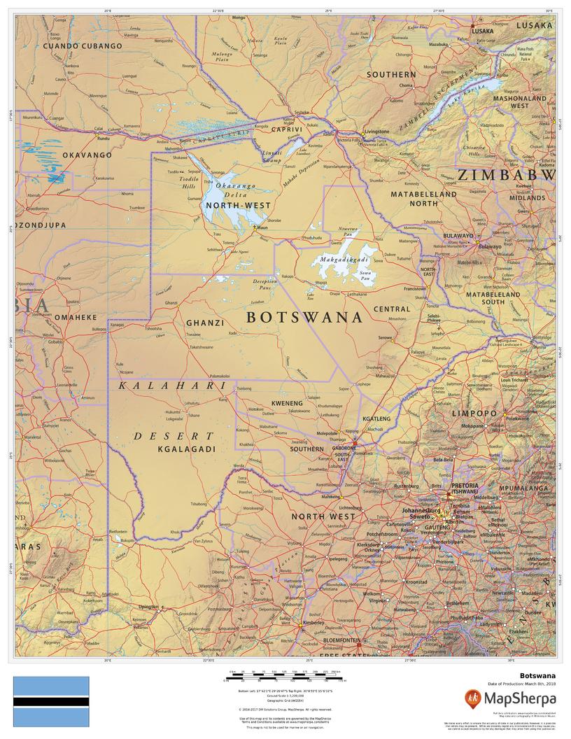
Discover the heart of Southern Africa with a compact, beautifully rendered Botswana Wall Map. Clear political boundaries pair with elegant color-by-elevation shading to showcase Botswana’s signature landscapes—from the shimmering Okavango Delta and arid Kalahari to the wildlife corridors of Chobe. Ideal for homes, classrooms, offices, and travel planning.
🗺️ Features & Highlights
-
Comprehensive Political View: National and regional boundaries with key cities and towns, including Gaborone, Francistown, Maun, and Kasane.
-
Terrain at a Glance: Shaded relief and elevation colors bring deserts, pans, and wetlands to life.
-
Rivers & Corridors: Major waterways such as the Okavango, Chobe, and Limpopo for quick orientation.
-
Regional Context: Neighboring Namibia, South Africa, Zimbabwe, and Zambia shown for cross-border perspective.
-
Clear Cartography: Clean fonts and legible symbols designed for quick reference at arm’s length.
✨ Available Finishes
| Format | Description |
|---|---|
| 📜 Paper (160 gsm) | Heavyweight matte-coated paper—perfect for framing under glass. |
| 🧼 Laminated (Encapsulated) | Fully sealed in 80-micron gloss laminate—durable, wipe-clean, ideal for frequent use. |
| 🪵 Laminated with Wooden Hang Rails | Laminated map mounted with lacquered natural timber rails (top & bottom) and a hanging cord—ready to hang. |
| 🖼️ Canvas (395 gsm) | HP Professional Matte Canvas with archival pigment inks—rich texture, fade-resistant, gallery quality. |
| 🪵 Canvas with Wooden Hang Rails | Canvas mounted with timber rails and hanging cord—timeless, ready-to-display finish (no frame required). |
🔨 Note: Hang-railed maps are custom mounted—please allow up to 10 working days.
📐 Specifications
| Feature | Detail |
|---|---|
| Title | Botswana Wall Map |
| Map Type | Physical / Political |
| Scale | 1:3,200,000 |
| Dimensions | 432 mm (W) × 559 mm (H) |
| Materials | Paper, Laminated, Canvas, with/without Timber Rails |
| Printing | Pigment-based, fade-resistant inks |
| Made In | Australia |
🎁 Perfect For
-
Home & Office Décor: A refined focal piece with real geographic depth.
-
Education & Libraries: Durable finishes for daily reference and lessons.
-
Travel & Fieldwork: Compact size with essential routes, rivers, and towns.
-
Map Enthusiasts: Collectible craftsmanship and clean, modern design.
🚚 Delivery
-
Paper, Laminated, Canvas (rolled): Typically ship within 1–2 business days.
-
Hang-Railed Maps: Made to order—please allow up to 10 working days.
-
Protective Packaging: Securely packed to arrive in perfect condition.
Bring Botswana’s deserts, deltas, and wildlife frontiers to your wall—choose your finish and add to cart today.


