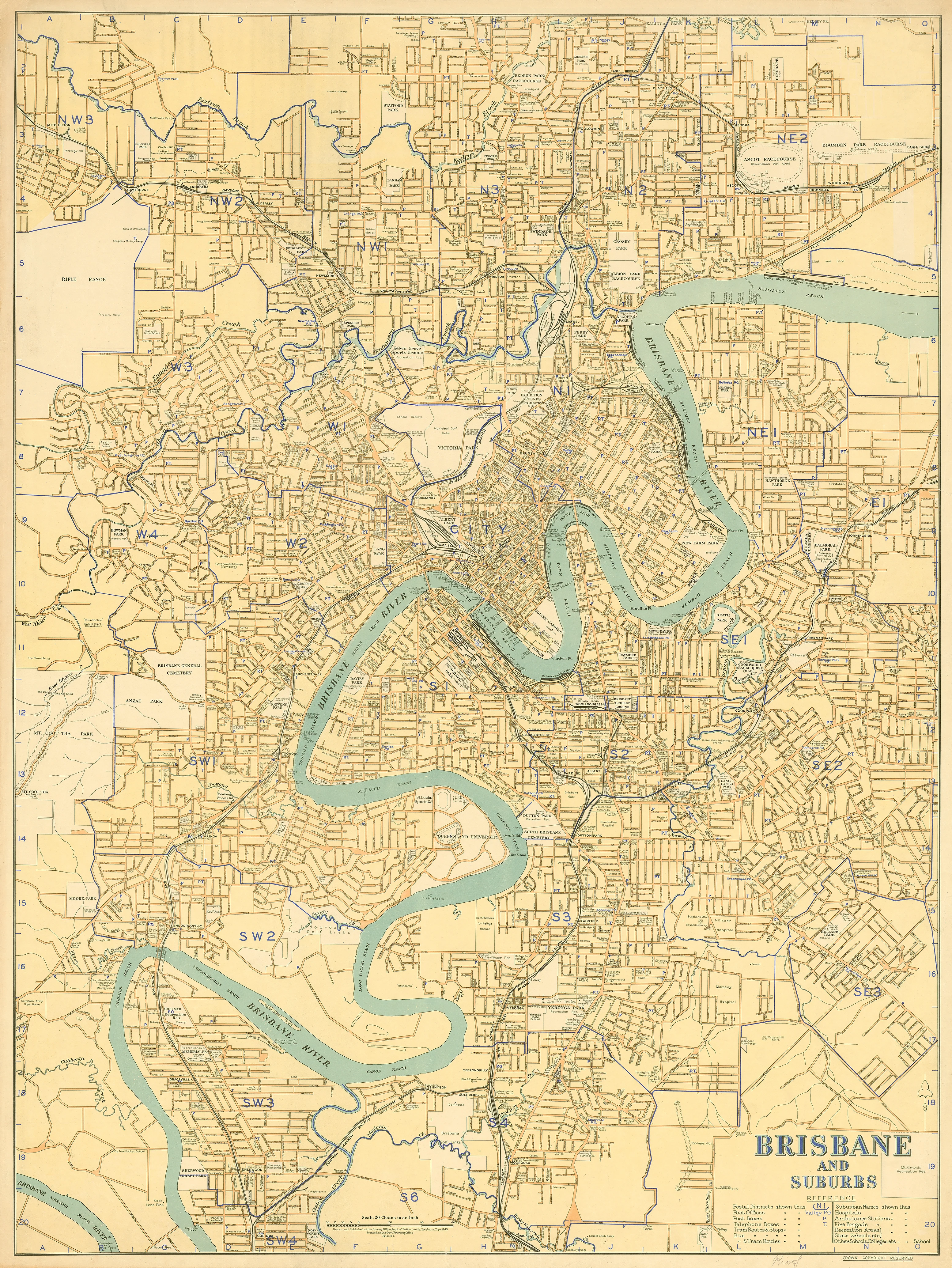
Brisbane and Suburbs — Street & Road Map (1943)
Brisbane and Suburbs — Street & Road Map (1943)
Creator: S. C. Glover
Produced by: Queensland Survey Office
Publisher: Department of Public Lands, Brisbane
Date: 1943
Size: 990 mm (W) × 740 mm (H)
Format: Historical Street & Road Map • Single Sheet
Printed in Australia
Produced in 1943, at the height of the Second World War, this official street and road map of Brisbane and its suburbs captures the city at a pivotal moment in its development. Compiled by S. C. Glover for the Queensland Government’s Survey Office, the map reflects Brisbane’s growing strategic importance, evolving transport routes, and expanding suburban footprint during the wartime years.
Clear, practical, and authoritative, this map shows Brisbane before the post-war population boom and the construction of modern motorways dramatically reshaped the city. It presents a metropolitan area that is compact by today’s standards, yet already structured around the corridors that would later define Greater Brisbane.
This is both a significant historical document and a compelling wall map — ideal for collectors, researchers, educators, and anyone interested in Brisbane’s wartime and early-modern urban form.
🗺️ What This Map Shows
-
Street and road network of Brisbane (1943) — city centre and surrounding suburbs
-
Wartime-era suburban layout — prior to large-scale post-war development
-
Primary and secondary roads — revealing transport priorities of the time
-
Government survey cartography — precise, functional, and data-driven
The emphasis is on clarity and usability, reflecting its role as an official planning and reference map.
🕰️ Brisbane in 1943 — Historical Context
-
Produced during World War II, when Brisbane was a major Allied base
-
Shows the city before extensive suburban sprawl and freeway systems
-
Reflects early-20th-century planning principles and road hierarchies
-
Provides crucial context for understanding Brisbane’s post-war transformation
Maps like this were tools of coordination and governance — today, they’re windows into Brisbane’s past.
🎨 Materials, Print Quality & Hanging Options
Archival Canvas
-
Printed on 395 gsm HP Professional Matte Canvas
-
Subtle canvas texture enhances colour depth while retaining fine line detail
-
Matte surface reduces reflections compared with glass-framed prints
Archival Pigment Inks
-
Produced using Hewlett-Packard archival, fade-resistant pigment inks
-
Ensures crisp typography, stable colour, and long-term durability
-
Designed to remain vibrant and legible for many years
Optional Timber Hang Rails (Recommended for Large Formats)
For a clean, frame-free presentation, this canvas map can be finished with natural timber hang rails:
-
Top and bottom timber rails provide structure and visual balance
-
Bottom rail adds weight, helping the canvas hang flat and straight
-
Prevents edge curl and sag over time
-
Supplied with hanging cord — ready to mount on a single wall hook
-
Creates a gallery-style finish without glass or bulky framing
Please note:
Canvas maps with timber hang rails are professionally finished.
Allow up to 10 working days for completion prior to dispatch.
This canvas edition is intended for display and reference and is not write-on / wipe-off like laminated versions.
📐 Size & Orientation
-
990 mm (W) × 740 mm (H)
-
Orientation: Landscape
A generous wall size that makes street detail easy to read while fitting comfortably in offices, studies, and shared spaces.
📊 Specifications
| Attribute | Details |
|---|---|
| Title | Brisbane and Suburbs — Street & Road Map |
| Creator | S. C. Glover |
| Authority | Queensland Survey Office |
| Publisher | Department of Public Lands, Brisbane |
| Date | 1943 |
| Coverage | Brisbane city and surrounding suburbs |
| Content | Streets and roads |
| Scale | Not given |
| Sheet Size | 990 mm × 740 mm |
| Material | 395 gsm HP Professional Matte Canvas |
| Inks | Hewlett-Packard archival, fade-resistant pigment inks |
| Optional Hanging | Natural timber hang rails (top & bottom) |
| Language | English |
| Origin | Printed in Australia (reproduction) |
🎯 Who It’s For
-
🏛️ Brisbane history enthusiasts — wartime and early-modern city insights
-
🧬 Genealogists & researchers — contextualising historic addresses
-
🎓 Educators & libraries — teaching urban and WWII-era Australian history
-
🏠 Homeowners & stylists — a refined mid-century heritage feature
-
🖼️ Collectors — an important Queensland government cartographic record
🤝 Our Commitment
This historic Brisbane map is reproduced and printed in Australia using archival-grade canvas and Hewlett-Packard pigment inks, with careful colour management to preserve the intent and clarity of the original 1943 government sheet. Each print is hand-checked and packed with care, ensuring it arrives ready to be enjoyed for years to come.
🛒 Explore Brisbane as it stood in 1943 — order the Brisbane and Suburbs Street & Road Map and bring a pivotal chapter of the city’s story onto your wall.
Original: $64.36
-65%$64.36
$22.53Product Information
Product Information
Shipping & Returns
Shipping & Returns
Description
Brisbane and Suburbs — Street & Road Map (1943)
Creator: S. C. Glover
Produced by: Queensland Survey Office
Publisher: Department of Public Lands, Brisbane
Date: 1943
Size: 990 mm (W) × 740 mm (H)
Format: Historical Street & Road Map • Single Sheet
Printed in Australia
Produced in 1943, at the height of the Second World War, this official street and road map of Brisbane and its suburbs captures the city at a pivotal moment in its development. Compiled by S. C. Glover for the Queensland Government’s Survey Office, the map reflects Brisbane’s growing strategic importance, evolving transport routes, and expanding suburban footprint during the wartime years.
Clear, practical, and authoritative, this map shows Brisbane before the post-war population boom and the construction of modern motorways dramatically reshaped the city. It presents a metropolitan area that is compact by today’s standards, yet already structured around the corridors that would later define Greater Brisbane.
This is both a significant historical document and a compelling wall map — ideal for collectors, researchers, educators, and anyone interested in Brisbane’s wartime and early-modern urban form.
🗺️ What This Map Shows
-
Street and road network of Brisbane (1943) — city centre and surrounding suburbs
-
Wartime-era suburban layout — prior to large-scale post-war development
-
Primary and secondary roads — revealing transport priorities of the time
-
Government survey cartography — precise, functional, and data-driven
The emphasis is on clarity and usability, reflecting its role as an official planning and reference map.
🕰️ Brisbane in 1943 — Historical Context
-
Produced during World War II, when Brisbane was a major Allied base
-
Shows the city before extensive suburban sprawl and freeway systems
-
Reflects early-20th-century planning principles and road hierarchies
-
Provides crucial context for understanding Brisbane’s post-war transformation
Maps like this were tools of coordination and governance — today, they’re windows into Brisbane’s past.
🎨 Materials, Print Quality & Hanging Options
Archival Canvas
-
Printed on 395 gsm HP Professional Matte Canvas
-
Subtle canvas texture enhances colour depth while retaining fine line detail
-
Matte surface reduces reflections compared with glass-framed prints
Archival Pigment Inks
-
Produced using Hewlett-Packard archival, fade-resistant pigment inks
-
Ensures crisp typography, stable colour, and long-term durability
-
Designed to remain vibrant and legible for many years
Optional Timber Hang Rails (Recommended for Large Formats)
For a clean, frame-free presentation, this canvas map can be finished with natural timber hang rails:
-
Top and bottom timber rails provide structure and visual balance
-
Bottom rail adds weight, helping the canvas hang flat and straight
-
Prevents edge curl and sag over time
-
Supplied with hanging cord — ready to mount on a single wall hook
-
Creates a gallery-style finish without glass or bulky framing
Please note:
Canvas maps with timber hang rails are professionally finished.
Allow up to 10 working days for completion prior to dispatch.
This canvas edition is intended for display and reference and is not write-on / wipe-off like laminated versions.
📐 Size & Orientation
-
990 mm (W) × 740 mm (H)
-
Orientation: Landscape
A generous wall size that makes street detail easy to read while fitting comfortably in offices, studies, and shared spaces.
📊 Specifications
| Attribute | Details |
|---|---|
| Title | Brisbane and Suburbs — Street & Road Map |
| Creator | S. C. Glover |
| Authority | Queensland Survey Office |
| Publisher | Department of Public Lands, Brisbane |
| Date | 1943 |
| Coverage | Brisbane city and surrounding suburbs |
| Content | Streets and roads |
| Scale | Not given |
| Sheet Size | 990 mm × 740 mm |
| Material | 395 gsm HP Professional Matte Canvas |
| Inks | Hewlett-Packard archival, fade-resistant pigment inks |
| Optional Hanging | Natural timber hang rails (top & bottom) |
| Language | English |
| Origin | Printed in Australia (reproduction) |
🎯 Who It’s For
-
🏛️ Brisbane history enthusiasts — wartime and early-modern city insights
-
🧬 Genealogists & researchers — contextualising historic addresses
-
🎓 Educators & libraries — teaching urban and WWII-era Australian history
-
🏠 Homeowners & stylists — a refined mid-century heritage feature
-
🖼️ Collectors — an important Queensland government cartographic record
🤝 Our Commitment
This historic Brisbane map is reproduced and printed in Australia using archival-grade canvas and Hewlett-Packard pigment inks, with careful colour management to preserve the intent and clarity of the original 1943 government sheet. Each print is hand-checked and packed with care, ensuring it arrives ready to be enjoyed for years to come.
🛒 Explore Brisbane as it stood in 1943 — order the Brisbane and Suburbs Street & Road Map and bring a pivotal chapter of the city’s story onto your wall.


