Britain & Ireland Executive Antique Style National Geographic 597 x 768mm Wall Map
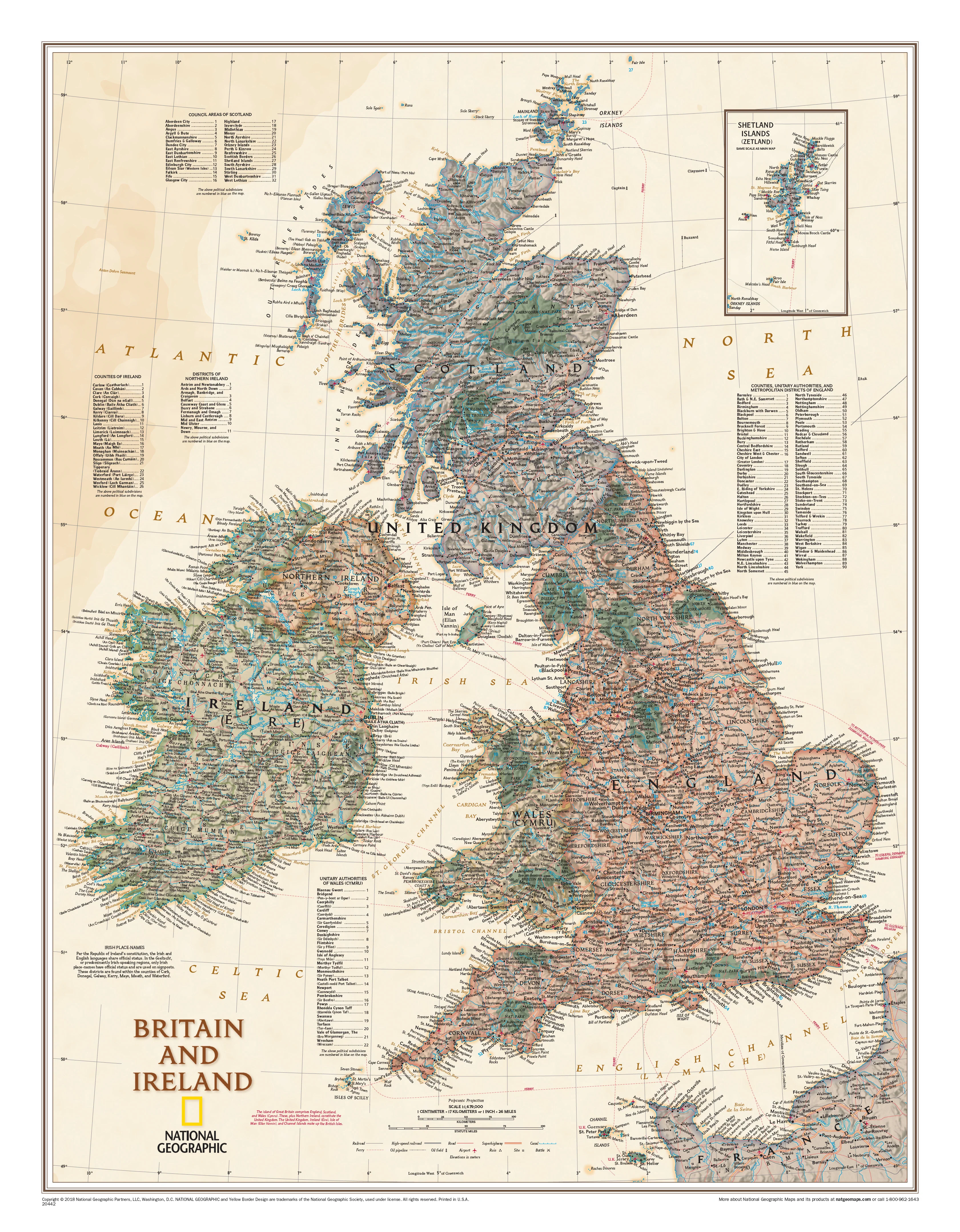
🇬🇧 Britain & Ireland Executive Antique-Style Wall Map
National Geographic | 597 x 768 mm | Scale 1:1,678,000
A distinguished and timeless tribute to the heritage of the British Isles
Step back in time and explore the intricate political and geographic tapestry of Britain and Ireland with this beautifully crafted Executive-style wall map by National Geographic. Rendered in warm, antique tones and layered with exquisite shaded relief, this map combines classic design with modern accuracy — perfect for the home study, library, classroom, or office.
🏰 A Map of Story and Substance
This elegant cartographic piece does more than show roads and borders — it tells the story of nations shaped by centuries of history, language, and geography. Designed in National Geographic’s distinctive Executive style, the map invites close inspection while offering a warm, vintage aesthetic worthy of framing.
🗺️ Key Features
-
🏛 Elegant Antique Styling
A warm, parchment-inspired palette that pairs beautifully with wood, leather, and traditional decor. The shaded relief gives the map a three-dimensional texture that draws the eye. -
🏞 Rich Topographic & Political Detail
Discover thousands of place names, from major cities to small towns. Clearly marked counties, council areas, unitary authorities, and metropolitan districts across England, Scotland, Wales, Ireland, and Northern Ireland. -
✈️ Transport & Travel Networks
Includes ferry routes, airports, major highways, and roads — perfect for travel planning or visual reference. -
🗣️ Bilingual Place Names (English & Gaelic)
In accordance with the Republic of Ireland’s bilingual policy, place names are shown in both English and Irish. Regions designated as Gaeltacht (predominantly Irish-speaking) are labelled in Irish only — a respectful nod to cultural identity. -
🗾 Inset of the Shetland Islands
Preserves scale and detail by including a neatly drawn inset of the Shetlands. -
🌳 National Parks & Natural Features
Green vignettes indicate protected landscapes and national parks, while subtle relief shading brings the terrain to life.
🎓 Who Is This Map For?
This map makes an excellent gift or decorative piece for:
-
🧭 Travellers and explorers of the British Isles
-
🧬 Family historians and genealogy enthusiasts
-
📚 Teachers and students of geography or history
-
🖼️ Homeowners looking to enrich a study, hallway, or library
-
🎁 Gift-givers seeking a refined and meaningful present
-
🇮🇪 Expats and those with strong UK or Irish heritage
🖼️ Display Options
Choose a finish that suits your space and purpose:
| Format | Description |
|---|---|
| 📄 Paper (160 gsm) | Premium matte-coated paper – ideal for framing under glass in a classic setting. |
| 💧 Laminated | Gloss-laminated and fully encapsulated in 80-micron film – durable, wipeable, and long-lasting. |
| 🪵 Laminated + Timber Rails | Ready-to-hang with wooden hang rails in natural finish and top hanging cord – stylish and simple. |
| 🖼️ Canvas (395 gsm) | Heavy-duty HP Matte Canvas with archival pigment inks – textured, fade-resistant, and elegant. |
| 🪵 Canvas + Timber Rails | Includes hang-ready timber rollers for effortless, heritage-style display. |
⏳ Hang-railed options are handcrafted to order. Please allow up to 10 working days for dispatch.
📐 Specifications
| Attribute | Details |
|---|---|
| Title | Britain & Ireland – Executive Style Political Map |
| Publisher | National Geographic |
| Edition | 2018 |
| Scale | 1:1,678,000 |
| Dimensions | 597 mm (W) × 768 mm (H) |
| Insets | Shetland Islands |
| Languages | English & Irish Gaelic (where applicable) |
| Materials Available | Paper, Laminated, Laminated + Rails, Canvas, Canvas + Rails |
| Made In | Australia |
🌟 A Heritage Display for Generations
Whether you're honouring your ancestry, teaching young minds, or simply appreciating the beauty of historic cartography, this Executive map offers both form and function. Its blend of elegance and accuracy ensures that it will remain a treasured part of your space for years to come.
🛒 Bring timeless Britain and Ireland into your home or office — order your National Geographic Executive map today and let the story unfold.
Original: $42.89
-65%$42.89
$15.01Product Information
Product Information
Shipping & Returns
Shipping & Returns
Description
🇬🇧 Britain & Ireland Executive Antique-Style Wall Map
National Geographic | 597 x 768 mm | Scale 1:1,678,000
A distinguished and timeless tribute to the heritage of the British Isles
Step back in time and explore the intricate political and geographic tapestry of Britain and Ireland with this beautifully crafted Executive-style wall map by National Geographic. Rendered in warm, antique tones and layered with exquisite shaded relief, this map combines classic design with modern accuracy — perfect for the home study, library, classroom, or office.
🏰 A Map of Story and Substance
This elegant cartographic piece does more than show roads and borders — it tells the story of nations shaped by centuries of history, language, and geography. Designed in National Geographic’s distinctive Executive style, the map invites close inspection while offering a warm, vintage aesthetic worthy of framing.
🗺️ Key Features
-
🏛 Elegant Antique Styling
A warm, parchment-inspired palette that pairs beautifully with wood, leather, and traditional decor. The shaded relief gives the map a three-dimensional texture that draws the eye. -
🏞 Rich Topographic & Political Detail
Discover thousands of place names, from major cities to small towns. Clearly marked counties, council areas, unitary authorities, and metropolitan districts across England, Scotland, Wales, Ireland, and Northern Ireland. -
✈️ Transport & Travel Networks
Includes ferry routes, airports, major highways, and roads — perfect for travel planning or visual reference. -
🗣️ Bilingual Place Names (English & Gaelic)
In accordance with the Republic of Ireland’s bilingual policy, place names are shown in both English and Irish. Regions designated as Gaeltacht (predominantly Irish-speaking) are labelled in Irish only — a respectful nod to cultural identity. -
🗾 Inset of the Shetland Islands
Preserves scale and detail by including a neatly drawn inset of the Shetlands. -
🌳 National Parks & Natural Features
Green vignettes indicate protected landscapes and national parks, while subtle relief shading brings the terrain to life.
🎓 Who Is This Map For?
This map makes an excellent gift or decorative piece for:
-
🧭 Travellers and explorers of the British Isles
-
🧬 Family historians and genealogy enthusiasts
-
📚 Teachers and students of geography or history
-
🖼️ Homeowners looking to enrich a study, hallway, or library
-
🎁 Gift-givers seeking a refined and meaningful present
-
🇮🇪 Expats and those with strong UK or Irish heritage
🖼️ Display Options
Choose a finish that suits your space and purpose:
| Format | Description |
|---|---|
| 📄 Paper (160 gsm) | Premium matte-coated paper – ideal for framing under glass in a classic setting. |
| 💧 Laminated | Gloss-laminated and fully encapsulated in 80-micron film – durable, wipeable, and long-lasting. |
| 🪵 Laminated + Timber Rails | Ready-to-hang with wooden hang rails in natural finish and top hanging cord – stylish and simple. |
| 🖼️ Canvas (395 gsm) | Heavy-duty HP Matte Canvas with archival pigment inks – textured, fade-resistant, and elegant. |
| 🪵 Canvas + Timber Rails | Includes hang-ready timber rollers for effortless, heritage-style display. |
⏳ Hang-railed options are handcrafted to order. Please allow up to 10 working days for dispatch.
📐 Specifications
| Attribute | Details |
|---|---|
| Title | Britain & Ireland – Executive Style Political Map |
| Publisher | National Geographic |
| Edition | 2018 |
| Scale | 1:1,678,000 |
| Dimensions | 597 mm (W) × 768 mm (H) |
| Insets | Shetland Islands |
| Languages | English & Irish Gaelic (where applicable) |
| Materials Available | Paper, Laminated, Laminated + Rails, Canvas, Canvas + Rails |
| Made In | Australia |
🌟 A Heritage Display for Generations
Whether you're honouring your ancestry, teaching young minds, or simply appreciating the beauty of historic cartography, this Executive map offers both form and function. Its blend of elegance and accuracy ensures that it will remain a treasured part of your space for years to come.
🛒 Bring timeless Britain and Ireland into your home or office — order your National Geographic Executive map today and let the story unfold.