Canada National Parks by National Geographic
Bilingual French–English | National Parks & Historic Sites | Premium Finishes
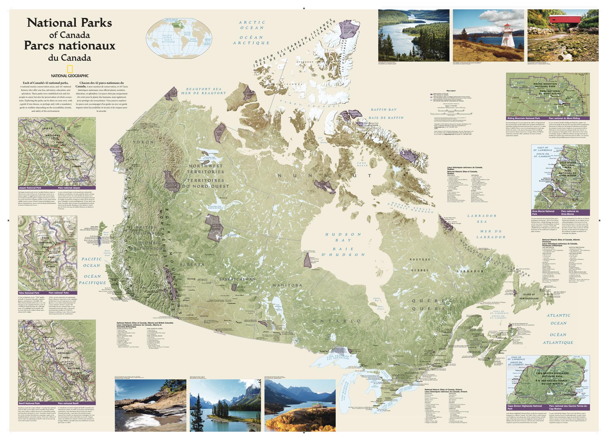
Celebrate the extraordinary natural beauty of Canada with National Geographic’s Canada National Parks Wall Map. Published in 2012, this beautifully designed map highlights the country’s magnificent national parks, marine conservation areas, and historic sites in a richly detailed, highly legible format. Rendered with shaded relief and clear provincial and territorial boundaries, it offers a sweeping portrait of Canada’s protected landscapes—from the Rockies and boreal forest to Atlantic headlands and Arctic wilderness.
This French–English bilingual edition is both a practical reference and a striking display piece, with colourful photographs and informative inset maps that bring some of Canada’s most beloved parks into sharper focus.
🗺️ Features & Highlights
-
National parks, marine conservation areas, and historic sites clearly identified across Canada
-
Bilingual French–English labelling for broad accessibility and educational value
-
Shaded relief cartography revealing mountain ranges, plains, coastlines, and major landforms
-
Provincial and territorial boundaries clearly shown for easy geographic orientation
-
Hundreds of cities labelled, including provincial and territorial capitals
-
Colour photographs showcasing the diversity of Canada’s protected landscapes
-
Inset maps with added detail and descriptions for several standout parks, including:
-
Jasper
-
Yoho
-
Banff
-
Riding Mountain
-
Gros Morne
-
Cape Breton Highlands
-
✨ Available Finishes
| Format | Description |
|---|---|
| 📜 Paper (160 gsm) | Heavyweight matte-coated paper—perfect for framing under glass. |
| 🧼 Laminated (Encapsulated) | Fully sealed in 80-micron gloss laminate for a durable, wipe-clean surface. |
| 🪵 Laminated with Wooden Hang Rails | Laminated map mounted with lacquered natural timber rails (top & bottom) and a hanging cord—ready to display. |
| 🖼️ Canvas (395 gsm) | HP Professional Matte Canvas with archival pigment inks—rich texture, fade-resistant, gallery quality. |
| 🪵 Canvas with Wooden Hang Rails | Canvas mounted with timber rails and hanging cord—timeless, ready-to-display finish. |
🔨 Note: Hang-railed maps are professionally mounted—please allow up to 10 working days.
📐 Specifications
| Feature | Detail |
|---|---|
| Title | Canada National Parks Wall Map |
| Publisher | National Geographic |
| Published | 2012 |
| Scale | 1:6,400,000 |
| Page Size | 1067 mm (W) × 762 mm (H) |
| Language | French–English bilingual |
| Map Type | National Parks / Protected Areas Reference |
| Materials | Paper, Laminated, Canvas, with or without Timber Rails |
| Printing | Pigment-based, fade-resistant inks |
| Made In | Australia |
🎁 Perfect For
-
National park lovers and outdoor enthusiasts
-
Canadian travel dreamers planning future adventures
-
Classrooms, libraries, and visitor spaces needing an engaging wall reference
-
Home and office décor with a wilderness, travel, or conservation theme
-
Gift-giving for hikers, campers, and map collectors
🚚 Delivery
-
Paper, Laminated, Canvas (rolled): Typically ship within 1–2 business days
-
Hang-Railed Maps: Made to order—please allow up to 10 working days
-
Protective Packaging: Securely packed to arrive in pristine condition
Bring the grandeur of Canada’s national parks to your wall with this beautifully detailed National Geographic map—an inspiring blend of geography, conservation, and adventure.
Original: $57.20
-65%$57.20
$20.02Product Information
Product Information
Shipping & Returns
Shipping & Returns
Description
Bilingual French–English | National Parks & Historic Sites | Premium Finishes
Celebrate the extraordinary natural beauty of Canada with National Geographic’s Canada National Parks Wall Map. Published in 2012, this beautifully designed map highlights the country’s magnificent national parks, marine conservation areas, and historic sites in a richly detailed, highly legible format. Rendered with shaded relief and clear provincial and territorial boundaries, it offers a sweeping portrait of Canada’s protected landscapes—from the Rockies and boreal forest to Atlantic headlands and Arctic wilderness.
This French–English bilingual edition is both a practical reference and a striking display piece, with colourful photographs and informative inset maps that bring some of Canada’s most beloved parks into sharper focus.
🗺️ Features & Highlights
-
National parks, marine conservation areas, and historic sites clearly identified across Canada
-
Bilingual French–English labelling for broad accessibility and educational value
-
Shaded relief cartography revealing mountain ranges, plains, coastlines, and major landforms
-
Provincial and territorial boundaries clearly shown for easy geographic orientation
-
Hundreds of cities labelled, including provincial and territorial capitals
-
Colour photographs showcasing the diversity of Canada’s protected landscapes
-
Inset maps with added detail and descriptions for several standout parks, including:
-
Jasper
-
Yoho
-
Banff
-
Riding Mountain
-
Gros Morne
-
Cape Breton Highlands
-
✨ Available Finishes
| Format | Description |
|---|---|
| 📜 Paper (160 gsm) | Heavyweight matte-coated paper—perfect for framing under glass. |
| 🧼 Laminated (Encapsulated) | Fully sealed in 80-micron gloss laminate for a durable, wipe-clean surface. |
| 🪵 Laminated with Wooden Hang Rails | Laminated map mounted with lacquered natural timber rails (top & bottom) and a hanging cord—ready to display. |
| 🖼️ Canvas (395 gsm) | HP Professional Matte Canvas with archival pigment inks—rich texture, fade-resistant, gallery quality. |
| 🪵 Canvas with Wooden Hang Rails | Canvas mounted with timber rails and hanging cord—timeless, ready-to-display finish. |
🔨 Note: Hang-railed maps are professionally mounted—please allow up to 10 working days.
📐 Specifications
| Feature | Detail |
|---|---|
| Title | Canada National Parks Wall Map |
| Publisher | National Geographic |
| Published | 2012 |
| Scale | 1:6,400,000 |
| Page Size | 1067 mm (W) × 762 mm (H) |
| Language | French–English bilingual |
| Map Type | National Parks / Protected Areas Reference |
| Materials | Paper, Laminated, Canvas, with or without Timber Rails |
| Printing | Pigment-based, fade-resistant inks |
| Made In | Australia |
🎁 Perfect For
-
National park lovers and outdoor enthusiasts
-
Canadian travel dreamers planning future adventures
-
Classrooms, libraries, and visitor spaces needing an engaging wall reference
-
Home and office décor with a wilderness, travel, or conservation theme
-
Gift-giving for hikers, campers, and map collectors
🚚 Delivery
-
Paper, Laminated, Canvas (rolled): Typically ship within 1–2 business days
-
Hang-Railed Maps: Made to order—please allow up to 10 working days
-
Protective Packaging: Securely packed to arrive in pristine condition
Bring the grandeur of Canada’s national parks to your wall with this beautifully detailed National Geographic map—an inspiring blend of geography, conservation, and adventure.


