Central America National Geographic 730 x 567mm Wall Map
Classic Style | Physical & Political Detail | Premium Finishes
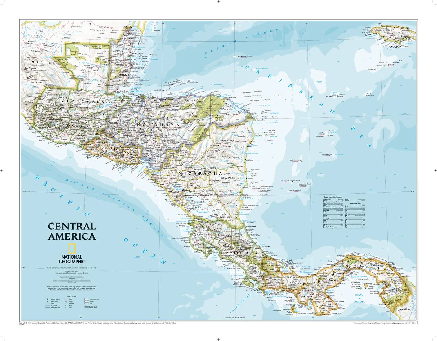
Explore the vibrant heart of Central America with National Geographic’s Classic-style wall map—where elegant design meets cartographic precision. Featuring a bright, easy-to-read palette, stunning shaded relief, and meticulous labeling, this map brings the landscapes and cultures of the region to life from the Caribbean Sea to the Pacific Ocean.
🗺️ Features & Highlights
-
Complete Regional Coverage: Includes Guatemala, Belize, El Salvador, Honduras, Nicaragua, Costa Rica, and Panama presented with accurate international and internal boundaries.
-
Shaded Relief & Bathymetry: Terrain rendered in rich relief; coastal bathymetry with depth curves and soundings shows underwater form along both coasts.
-
Thousands of Place Names: Clear labeling for capitals, major cities, towns, islands, and key landforms for effortless reference.
-
National Parks & Archaeology: Highlights protected areas and archaeological sites (e.g., Tikal, Copán), perfect for learners and travelers alike.
-
Infrastructure at a Glance: Major roads & highways, rail lines, airports, canals (including the Panama Canal), and ferry routes to visualize connectivity across the isthmus.
-
Classic National Geographic Aesthetic: Signature typography and color bring elegance to classrooms, home offices, and studios.
✨ Available Finishes
| Format | Description |
|---|---|
| 📜 Paper (160 gsm) | Heavyweight matte-coated paper—perfect for framing under glass. |
| 🧼 Laminated (Encapsulated) | Fully sealed in 80-micron gloss laminate for a durable, wipe-clean surface—ideal for classrooms and high-traffic spaces. |
| 🪵 Laminated with Wooden Hang Rails | Laminated map mounted with lacquered natural timber rails (top & bottom) and a sturdy hanging cord—ready to display. |
| 🖼️ Canvas (395 gsm) | HP Professional Matte Canvas printed with archival pigment inks—rich texture, fade-resistant, gallery-quality. |
| 🪵 Canvas with Wooden Hang Rails | Canvas mounted with timber rails and hanging cord—no frame needed for a timeless, exhibition-style presentation. |
🔨 Note: Hang-railed maps are custom mounted—please allow up to 10 working days.
📐 Specifications
| Feature | Detail |
|---|---|
| Title | Central America National Geographic Wall Map |
| Map Type | Physical & Political |
| Dimensions | 730 mm (W) × 567 mm (H) |
| Materials | Paper, Laminated, Canvas; with/without Timber Rails |
| Printing | Pigment-based, fade-resistant inks |
| Made In | Australia |
🎁 Perfect For
-
Education & Homeschooling: Geography, history, and environmental studies across the isthmus.
-
Travel & Business Planning: Visualize routes, hubs, and cross-border connections.
-
Home & Office Décor: A refined focal piece with both style and substance.
🚚 Delivery
-
Paper, Laminated & Canvas (rolled): Typically ship within 1–2 business days.
-
Hang-Railed Maps: Made to order—please allow up to 10 working days.
-
Secure Packaging: Shipped in protective materials to ensure pristine arrival.
Bring the people, places, and pathways of Central America into clear focus—
Add to cart and elevate your space with National Geographic cartography.
Original: $42.89
-65%$42.89
$15.01Product Information
Product Information
Shipping & Returns
Shipping & Returns
Description
Classic Style | Physical & Political Detail | Premium Finishes
Explore the vibrant heart of Central America with National Geographic’s Classic-style wall map—where elegant design meets cartographic precision. Featuring a bright, easy-to-read palette, stunning shaded relief, and meticulous labeling, this map brings the landscapes and cultures of the region to life from the Caribbean Sea to the Pacific Ocean.
🗺️ Features & Highlights
-
Complete Regional Coverage: Includes Guatemala, Belize, El Salvador, Honduras, Nicaragua, Costa Rica, and Panama presented with accurate international and internal boundaries.
-
Shaded Relief & Bathymetry: Terrain rendered in rich relief; coastal bathymetry with depth curves and soundings shows underwater form along both coasts.
-
Thousands of Place Names: Clear labeling for capitals, major cities, towns, islands, and key landforms for effortless reference.
-
National Parks & Archaeology: Highlights protected areas and archaeological sites (e.g., Tikal, Copán), perfect for learners and travelers alike.
-
Infrastructure at a Glance: Major roads & highways, rail lines, airports, canals (including the Panama Canal), and ferry routes to visualize connectivity across the isthmus.
-
Classic National Geographic Aesthetic: Signature typography and color bring elegance to classrooms, home offices, and studios.
✨ Available Finishes
| Format | Description |
|---|---|
| 📜 Paper (160 gsm) | Heavyweight matte-coated paper—perfect for framing under glass. |
| 🧼 Laminated (Encapsulated) | Fully sealed in 80-micron gloss laminate for a durable, wipe-clean surface—ideal for classrooms and high-traffic spaces. |
| 🪵 Laminated with Wooden Hang Rails | Laminated map mounted with lacquered natural timber rails (top & bottom) and a sturdy hanging cord—ready to display. |
| 🖼️ Canvas (395 gsm) | HP Professional Matte Canvas printed with archival pigment inks—rich texture, fade-resistant, gallery-quality. |
| 🪵 Canvas with Wooden Hang Rails | Canvas mounted with timber rails and hanging cord—no frame needed for a timeless, exhibition-style presentation. |
🔨 Note: Hang-railed maps are custom mounted—please allow up to 10 working days.
📐 Specifications
| Feature | Detail |
|---|---|
| Title | Central America National Geographic Wall Map |
| Map Type | Physical & Political |
| Dimensions | 730 mm (W) × 567 mm (H) |
| Materials | Paper, Laminated, Canvas; with/without Timber Rails |
| Printing | Pigment-based, fade-resistant inks |
| Made In | Australia |
🎁 Perfect For
-
Education & Homeschooling: Geography, history, and environmental studies across the isthmus.
-
Travel & Business Planning: Visualize routes, hubs, and cross-border connections.
-
Home & Office Décor: A refined focal piece with both style and substance.
🚚 Delivery
-
Paper, Laminated & Canvas (rolled): Typically ship within 1–2 business days.
-
Hang-Railed Maps: Made to order—please allow up to 10 working days.
-
Secure Packaging: Shipped in protective materials to ensure pristine arrival.
Bring the people, places, and pathways of Central America into clear focus—
Add to cart and elevate your space with National Geographic cartography.


