Central America Past and Present - Published 1986 by National Geographic
Historical & Thematic Reference | Educational Insets | Premium Finishes
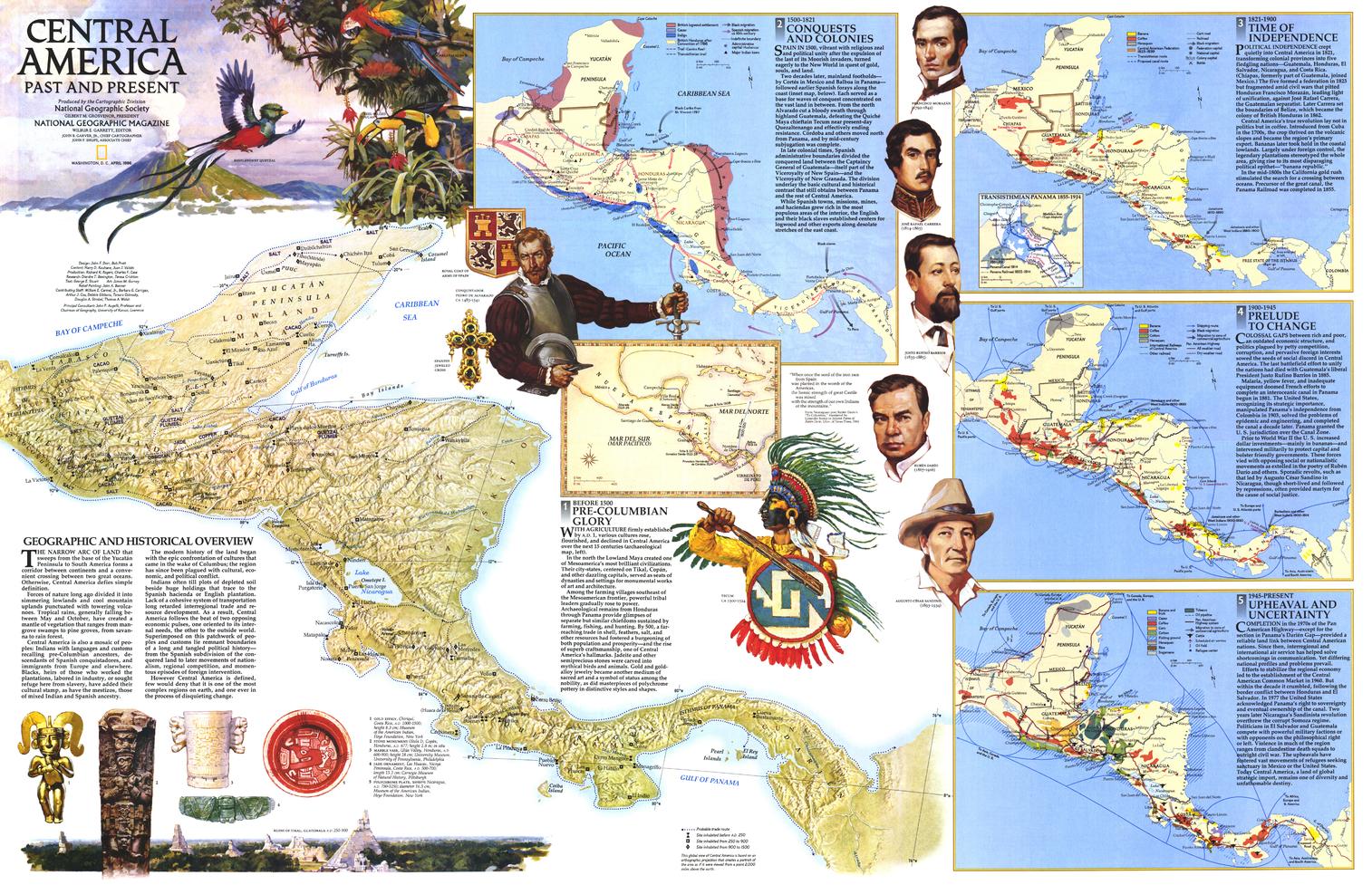
Discover the layered story of Central America with this richly illustrated National Geographic map, published in April 1986. Issued as one half of a two-map set, it accompanied the political map of Central America in the same issue and offers a vivid, educational look at the region’s past and present.
This beautifully composed thematic map features six individual inset maps exploring the history and development of Central America, complemented by colourful illustrations of historical figures, artefacts, and wildlife. It is an engaging blend of geography, history, and visual storytelling—perfect for classrooms, libraries, collectors, and anyone fascinated by the cultural depth of the region.
🗺️ Features & Highlights
-
Historical and thematic focus presenting Central America through multiple educational map panels
-
Six inset maps highlighting key aspects of the region’s history and development
-
Illustrated visual elements including historical figures, artefacts, and wildlife for added educational appeal
-
Published as part of a two-map set, paired with the political map of Central America
-
A wonderful example of National Geographic’s educational cartography from the 1980s
-
Ideal for those interested in regional history, culture, and thematic mapping
✨ Available Finishes
| Format | Description |
|---|---|
| 📜 Paper (160 gsm) | Heavyweight matte-coated paper—perfect for framing under glass. |
| 🧼 Laminated (Encapsulated) | Fully sealed in 80-micron gloss laminate for a durable, wipe-clean surface. |
| 🪵 Laminated with Wooden Hang Rails | Laminated map mounted with lacquered natural timber rails (top & bottom) and a hanging cord—ready to display. |
| 🖼️ Canvas (395 gsm) | HP Professional Matte Canvas with archival pigment inks—rich texture, fade-resistant, gallery quality. |
| 🪵 Canvas with Wooden Hang Rails | Canvas mounted with timber rails and hanging cord—timeless, ready-to-display finish. |
🔨 Note: Hang-railed maps are professionally mounted—please allow up to 10 working days.
📐 Specifications
| Feature | Detail |
|---|---|
| Title | Central America Past and Present |
| Publisher | National Geographic |
| Published | 1986 |
| Page Size | 801 mm (W) × 517 mm (H) |
| Collections | Central America & Caribbean, North America, Historical, Thematic Map |
| Map Type | Historical / Thematic Reference |
| Materials | Paper, Laminated, Canvas, with or without Timber Rails |
| Printing | Pigment-based, fade-resistant inks |
| Made In | Australia |
🎁 Perfect For
-
Teachers and educators looking for an engaging wall resource
-
Collectors of vintage National Geographic maps
-
Students of Central American history and culture
-
Libraries, classrooms, and studies needing a thematic regional map
-
Home and office décor with educational and historical depth
🚚 Delivery
-
Paper, Laminated, Canvas (rolled): Typically ship within 1–2 business days
-
Hang-Railed Maps: Made to order—please allow up to 10 working days
-
Protective Packaging: Securely packed to arrive in pristine condition
Bring the history, culture, and visual richness of Central America to your wall with this classic 1986 National Geographic thematic map—an educational piece with enduring display appeal.
Original: $57.20
-65%$57.20
$20.02Product Information
Product Information
Shipping & Returns
Shipping & Returns
Description
Historical & Thematic Reference | Educational Insets | Premium Finishes
Discover the layered story of Central America with this richly illustrated National Geographic map, published in April 1986. Issued as one half of a two-map set, it accompanied the political map of Central America in the same issue and offers a vivid, educational look at the region’s past and present.
This beautifully composed thematic map features six individual inset maps exploring the history and development of Central America, complemented by colourful illustrations of historical figures, artefacts, and wildlife. It is an engaging blend of geography, history, and visual storytelling—perfect for classrooms, libraries, collectors, and anyone fascinated by the cultural depth of the region.
🗺️ Features & Highlights
-
Historical and thematic focus presenting Central America through multiple educational map panels
-
Six inset maps highlighting key aspects of the region’s history and development
-
Illustrated visual elements including historical figures, artefacts, and wildlife for added educational appeal
-
Published as part of a two-map set, paired with the political map of Central America
-
A wonderful example of National Geographic’s educational cartography from the 1980s
-
Ideal for those interested in regional history, culture, and thematic mapping
✨ Available Finishes
| Format | Description |
|---|---|
| 📜 Paper (160 gsm) | Heavyweight matte-coated paper—perfect for framing under glass. |
| 🧼 Laminated (Encapsulated) | Fully sealed in 80-micron gloss laminate for a durable, wipe-clean surface. |
| 🪵 Laminated with Wooden Hang Rails | Laminated map mounted with lacquered natural timber rails (top & bottom) and a hanging cord—ready to display. |
| 🖼️ Canvas (395 gsm) | HP Professional Matte Canvas with archival pigment inks—rich texture, fade-resistant, gallery quality. |
| 🪵 Canvas with Wooden Hang Rails | Canvas mounted with timber rails and hanging cord—timeless, ready-to-display finish. |
🔨 Note: Hang-railed maps are professionally mounted—please allow up to 10 working days.
📐 Specifications
| Feature | Detail |
|---|---|
| Title | Central America Past and Present |
| Publisher | National Geographic |
| Published | 1986 |
| Page Size | 801 mm (W) × 517 mm (H) |
| Collections | Central America & Caribbean, North America, Historical, Thematic Map |
| Map Type | Historical / Thematic Reference |
| Materials | Paper, Laminated, Canvas, with or without Timber Rails |
| Printing | Pigment-based, fade-resistant inks |
| Made In | Australia |
🎁 Perfect For
-
Teachers and educators looking for an engaging wall resource
-
Collectors of vintage National Geographic maps
-
Students of Central American history and culture
-
Libraries, classrooms, and studies needing a thematic regional map
-
Home and office décor with educational and historical depth
🚚 Delivery
-
Paper, Laminated, Canvas (rolled): Typically ship within 1–2 business days
-
Hang-Railed Maps: Made to order—please allow up to 10 working days
-
Protective Packaging: Securely packed to arrive in pristine condition
Bring the history, culture, and visual richness of Central America to your wall with this classic 1986 National Geographic thematic map—an educational piece with enduring display appeal.


