Central Europe Wall Map - Published 1951 by National Geographic
Occupation Lines & New Borders — Central Europe Wall Map (1951)
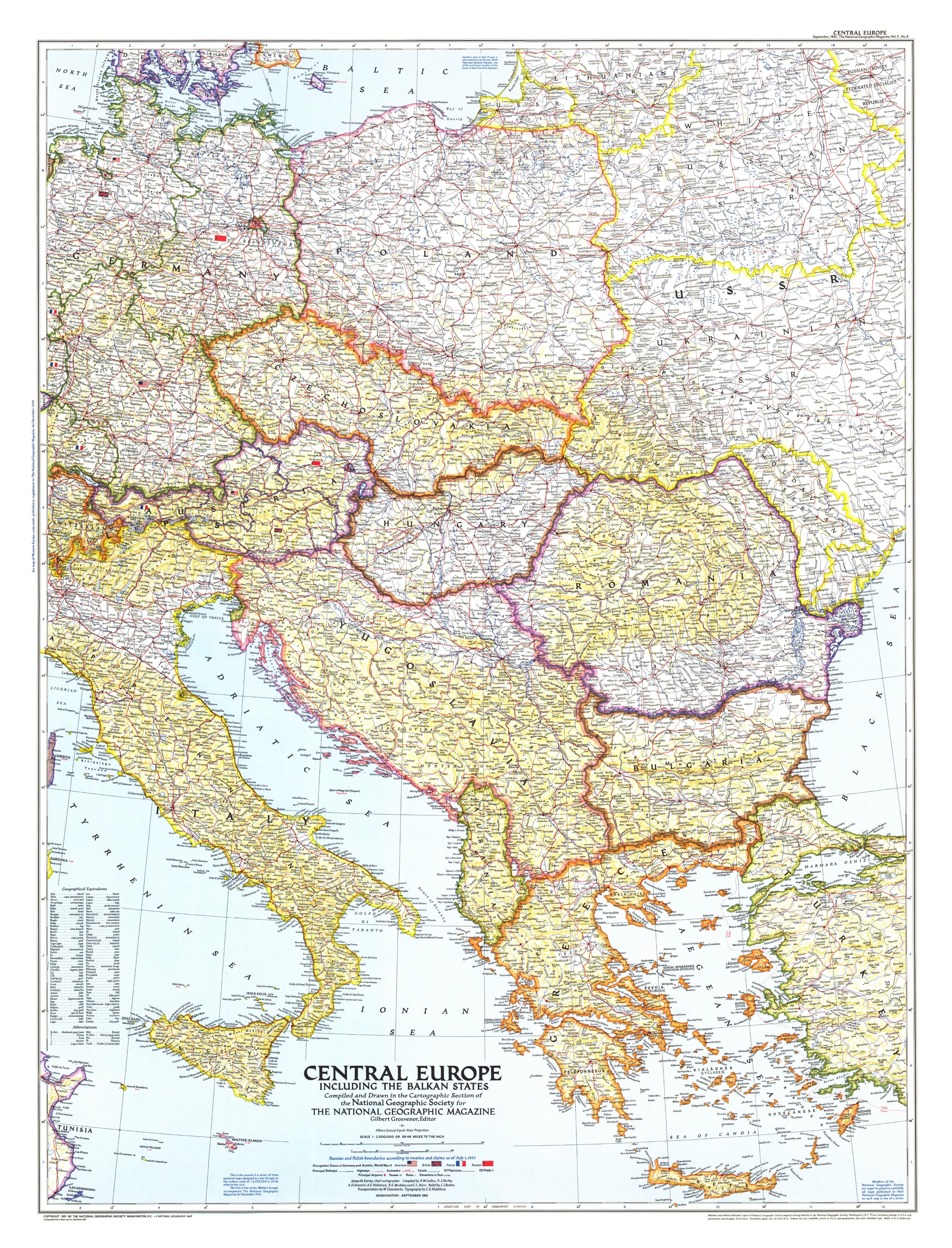
Europe in recovery, redrawn for a new era. Published by National Geographic in September 1951, this sheet surveys Central Europe and the Balkan States as the post-war order settles in: American, British, French, and Soviet occupation zones are clearly delineated, alongside the newly asserted Soviet boundaries. Clear symbology, balanced colour, and meticulous labeling make it equally at home in a study, classroom, or gallery wall.
More Than a Map – A Post-War Time Capsule
Not just wall art—this is a reference to the continent’s early Cold War geography. Track shifting frontiers, administrative divisions, and transport links at a pivotal moment in European history. Ideal for historians, educators, designers, and collectors, it rewards both room-distance viewing and close inspection.
Premium Materials & Finishes
🌟 Archival Paper Print
Printed on heavyweight 160gsm archival paper.
Matte finish limits glare and preserves fine linework—perfect for framing under glass.
💎 Laminated Edition
Encapsulated in two sheets of 80-micron gloss laminate (true thermal bonding).
Durable, moisture-resistant, and wipe-clean—great for classrooms and high-traffic spaces.
Optional Natural Timber Hang Rails: lacquered rails with fitted hanging cord for a clean, ready-to-hang look. (Please allow up to 10 working days with hang rails.)
🏆 Museum-Quality Canvas
Printed on 395gsm HP Professional Matte Canvas for rich texture and strength.
Pigment-based, fade-resistant inks keep tones deep and labels crisp for decades.
Optional Natural Timber Hang Rails: lacquered to enhance the grain; top cord for effortless hanging. (Please allow up to 10 working days with hang rails.)
Specifications
| Feature | Details |
|---|---|
| Title | Central Europe Wall Map |
| Region | Central Europe & the Balkan States |
| Publisher | National Geographic |
| Original Publication | September 1951 |
| Scale | 1:2,500,000 |
| Cartographic Content | Allied occupation zones (US/UK/FR/USSR); newly drawn Soviet borders; countries; major cities; transport; relief & hydrography |
| Map Size | 763 mm (W) × 999 mm (H) |
| Available Formats | Paper, Laminated, Canvas |
| Paper Weight | 160gsm archival-quality |
| Laminate | 2 × 80-micron gloss sheets (encapsulated) |
| Canvas Weight | 395gsm HP Professional Matte Canvas |
| Inks | Pigment-based, fade-resistant |
| Optional Hang Rails | Available on Laminated & Canvas (lead time up to 10 working days) |
| Origin | Made in Australia |
Why Choose This Map
✔ Definitive Post-War Snapshot: See occupation zones and early Cold War borders as mapped in 1951.
✔ Clarity & Authority: Classic National Geographic cartography—clean, legible, and richly informative.
✔ Scholarly & Decorative: Strong presence on the wall; rewarding detail up close.
✔ Archival Build: Premium substrates and inks safeguard contrast, labels, and linework.
Our Commitment
Printed locally in Australia, every map is colour-checked, inspected, and carefully packed. From press to wall, we focus on fidelity, durability, and beauty—so your map informs, inspires, and endures.
Capture a pivotal European moment. Order the Central Europe Wall Map (1951) today—a faithful, display-ready classic that turns a room into a conversation.
Original: $50.05
-65%$50.05
$17.52Product Information
Product Information
Shipping & Returns
Shipping & Returns
Description
Occupation Lines & New Borders — Central Europe Wall Map (1951)
Europe in recovery, redrawn for a new era. Published by National Geographic in September 1951, this sheet surveys Central Europe and the Balkan States as the post-war order settles in: American, British, French, and Soviet occupation zones are clearly delineated, alongside the newly asserted Soviet boundaries. Clear symbology, balanced colour, and meticulous labeling make it equally at home in a study, classroom, or gallery wall.
More Than a Map – A Post-War Time Capsule
Not just wall art—this is a reference to the continent’s early Cold War geography. Track shifting frontiers, administrative divisions, and transport links at a pivotal moment in European history. Ideal for historians, educators, designers, and collectors, it rewards both room-distance viewing and close inspection.
Premium Materials & Finishes
🌟 Archival Paper Print
Printed on heavyweight 160gsm archival paper.
Matte finish limits glare and preserves fine linework—perfect for framing under glass.
💎 Laminated Edition
Encapsulated in two sheets of 80-micron gloss laminate (true thermal bonding).
Durable, moisture-resistant, and wipe-clean—great for classrooms and high-traffic spaces.
Optional Natural Timber Hang Rails: lacquered rails with fitted hanging cord for a clean, ready-to-hang look. (Please allow up to 10 working days with hang rails.)
🏆 Museum-Quality Canvas
Printed on 395gsm HP Professional Matte Canvas for rich texture and strength.
Pigment-based, fade-resistant inks keep tones deep and labels crisp for decades.
Optional Natural Timber Hang Rails: lacquered to enhance the grain; top cord for effortless hanging. (Please allow up to 10 working days with hang rails.)
Specifications
| Feature | Details |
|---|---|
| Title | Central Europe Wall Map |
| Region | Central Europe & the Balkan States |
| Publisher | National Geographic |
| Original Publication | September 1951 |
| Scale | 1:2,500,000 |
| Cartographic Content | Allied occupation zones (US/UK/FR/USSR); newly drawn Soviet borders; countries; major cities; transport; relief & hydrography |
| Map Size | 763 mm (W) × 999 mm (H) |
| Available Formats | Paper, Laminated, Canvas |
| Paper Weight | 160gsm archival-quality |
| Laminate | 2 × 80-micron gloss sheets (encapsulated) |
| Canvas Weight | 395gsm HP Professional Matte Canvas |
| Inks | Pigment-based, fade-resistant |
| Optional Hang Rails | Available on Laminated & Canvas (lead time up to 10 working days) |
| Origin | Made in Australia |
Why Choose This Map
✔ Definitive Post-War Snapshot: See occupation zones and early Cold War borders as mapped in 1951.
✔ Clarity & Authority: Classic National Geographic cartography—clean, legible, and richly informative.
✔ Scholarly & Decorative: Strong presence on the wall; rewarding detail up close.
✔ Archival Build: Premium substrates and inks safeguard contrast, labels, and linework.
Our Commitment
Printed locally in Australia, every map is colour-checked, inspected, and carefully packed. From press to wall, we focus on fidelity, durability, and beauty—so your map informs, inspires, and endures.
Capture a pivotal European moment. Order the Central Europe Wall Map (1951) today—a faithful, display-ready classic that turns a room into a conversation.


