Children's Physical Map of Africa 668 x 805mm
🦁 Children’s Physical Map of Africa
Size: 668 x 805 mm | Scale: 1:12,000,000 | Published: 2019
Fun. Accessible. Designed for every child to see the beauty of Africa—clearly.
Inspire young minds with this beautifully designed Children’s Physical Map of Africa, specially created to be engaging, informative, and visually accessible to all children—including those with colour vision deficiencies.
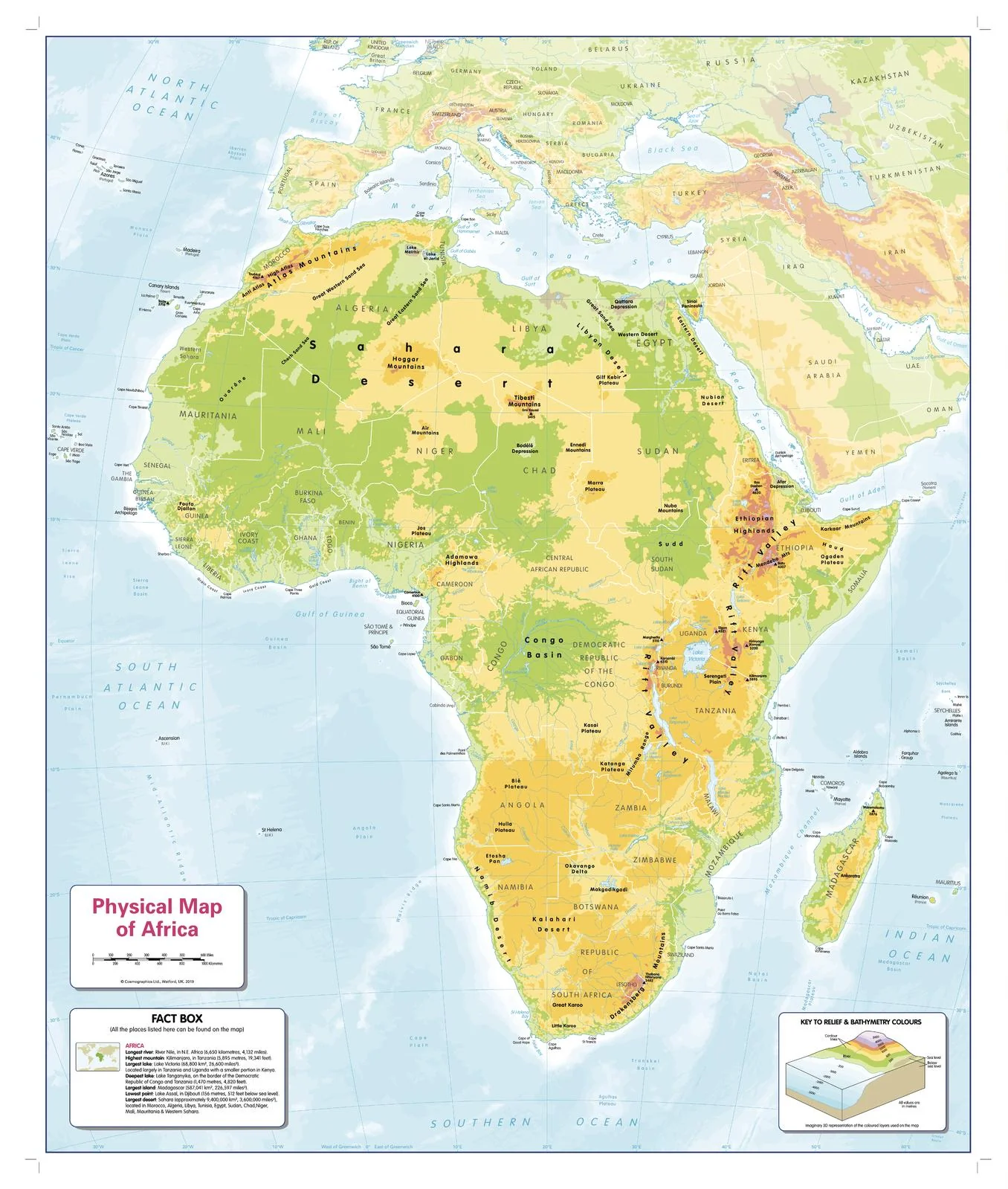
This bright and easy-to-read wall map highlights Africa’s major physical features, from mountains and deserts to rivers and ocean floors. It includes a kid-friendly facts box and is colour-optimised to be inclusive of all types of colour blindness, making it a powerful visual learning tool for any home, school, or library.
🗺️ Key Features
-
🏞️ Clear physical geography – mountains, rivers, deserts, lakes, and seabed features
-
🌊 Ocean floor detail – encourages understanding of Earth’s underwater landscapes
-
🎨 Inclusive colour palette – specially designed for all forms of colour blindness
-
📦 Fun facts box – simple, age-appropriate facts to spark curiosity
-
🧒 Child-friendly fonts and layout – easy to read and visually engaging
-
📐 Scaled at 1:12,000,000 – enough detail to learn, without overwhelming young learners
This is more than just a map—it’s a learning tool designed for inclusivity, clarity, and discovery.
🖼️ Available in Three Premium Formats
| Format | Material & Finish | Best For |
|---|---|---|
| Paper | Printed on heavyweight 160gsm matte paper | Ideal for framing under glass at home or school |
| Laminated | Fully encapsulated in 80-micron gloss laminate (both sides) – waterproof and whiteboard compatible | Great for classroom walls or frequent handling |
| Canvas | Printed on 395gsm HP Matte Canvas with pigment inks – durable and fade-resistant | Premium display in bedrooms, playrooms, or educational settings |
➕ Optional wooden hang rails available for laminated and canvas formats.
🪚 Optional Timber Hang Rails – Ready to Hang
Transform your laminated or canvas map into a striking educational centrepiece:
-
🪵 Satin-lacquered natural timber top and bottom rails
-
🧵 Corded top rail for effortless hanging
-
🖐️ Hand-finished by our professional framer
-
⏳ Please allow 10 working days for delivery of hang-railed maps
A ready-to-hang solution that adds style and structure to your space.
📐 Specifications
| Feature | Details |
|---|---|
| Title | Children’s Physical Map of Africa |
| Publisher | Cosmographics |
| Size | 668 mm (W) x 805 mm (H) |
| Scale | 1:12,000,000 |
| Edition | Published 2019 |
| Print Origin | Printed and finished in Australia |
| Optional Extras | Timber hang rails (Canvas & Laminated versions) |
🎓 Why This Map Belongs in Every Learning Space
🧠 Educational & Fun – Introduces geography with colour, clarity, and age-appropriate design
👁️ Inclusive by Design – A map every child can enjoy, regardless of colour vision
🏫 Perfect for Classrooms – Durable, engaging, and curriculum-friendly
🎁 A Meaningful Gift – Ideal for young explorers, budding geographers, or educators
🖼️ Made to Last – Fade-resistant inks and premium materials ensure years of enjoyment
Let the Children’s Physical Map of Africa turn curiosity into knowledge—one country, mountain, and river at a time. It’s a map that welcomes every child to the world of geography.
📦 Shipping Information
-
📄 Paper & Laminated formats: Ships in 1–2 business days
-
🖼️ Canvas & Timber Rail versions: Please allow 7–10 business days for finishing and dispatch
🛒 Add to Cart – Inspire Young Explorers Today
Encourage learning, inclusivity, and global awareness with a map designed to make a lasting impression.
Product Information
Product Information
Shipping & Returns
Shipping & Returns
Description
🦁 Children’s Physical Map of Africa
Size: 668 x 805 mm | Scale: 1:12,000,000 | Published: 2019
Fun. Accessible. Designed for every child to see the beauty of Africa—clearly.
Inspire young minds with this beautifully designed Children’s Physical Map of Africa, specially created to be engaging, informative, and visually accessible to all children—including those with colour vision deficiencies.
This bright and easy-to-read wall map highlights Africa’s major physical features, from mountains and deserts to rivers and ocean floors. It includes a kid-friendly facts box and is colour-optimised to be inclusive of all types of colour blindness, making it a powerful visual learning tool for any home, school, or library.
🗺️ Key Features
-
🏞️ Clear physical geography – mountains, rivers, deserts, lakes, and seabed features
-
🌊 Ocean floor detail – encourages understanding of Earth’s underwater landscapes
-
🎨 Inclusive colour palette – specially designed for all forms of colour blindness
-
📦 Fun facts box – simple, age-appropriate facts to spark curiosity
-
🧒 Child-friendly fonts and layout – easy to read and visually engaging
-
📐 Scaled at 1:12,000,000 – enough detail to learn, without overwhelming young learners
This is more than just a map—it’s a learning tool designed for inclusivity, clarity, and discovery.
🖼️ Available in Three Premium Formats
| Format | Material & Finish | Best For |
|---|---|---|
| Paper | Printed on heavyweight 160gsm matte paper | Ideal for framing under glass at home or school |
| Laminated | Fully encapsulated in 80-micron gloss laminate (both sides) – waterproof and whiteboard compatible | Great for classroom walls or frequent handling |
| Canvas | Printed on 395gsm HP Matte Canvas with pigment inks – durable and fade-resistant | Premium display in bedrooms, playrooms, or educational settings |
➕ Optional wooden hang rails available for laminated and canvas formats.
🪚 Optional Timber Hang Rails – Ready to Hang
Transform your laminated or canvas map into a striking educational centrepiece:
-
🪵 Satin-lacquered natural timber top and bottom rails
-
🧵 Corded top rail for effortless hanging
-
🖐️ Hand-finished by our professional framer
-
⏳ Please allow 10 working days for delivery of hang-railed maps
A ready-to-hang solution that adds style and structure to your space.
📐 Specifications
| Feature | Details |
|---|---|
| Title | Children’s Physical Map of Africa |
| Publisher | Cosmographics |
| Size | 668 mm (W) x 805 mm (H) |
| Scale | 1:12,000,000 |
| Edition | Published 2019 |
| Print Origin | Printed and finished in Australia |
| Optional Extras | Timber hang rails (Canvas & Laminated versions) |
🎓 Why This Map Belongs in Every Learning Space
🧠 Educational & Fun – Introduces geography with colour, clarity, and age-appropriate design
👁️ Inclusive by Design – A map every child can enjoy, regardless of colour vision
🏫 Perfect for Classrooms – Durable, engaging, and curriculum-friendly
🎁 A Meaningful Gift – Ideal for young explorers, budding geographers, or educators
🖼️ Made to Last – Fade-resistant inks and premium materials ensure years of enjoyment
Let the Children’s Physical Map of Africa turn curiosity into knowledge—one country, mountain, and river at a time. It’s a map that welcomes every child to the world of geography.
📦 Shipping Information
-
📄 Paper & Laminated formats: Ships in 1–2 business days
-
🖼️ Canvas & Timber Rail versions: Please allow 7–10 business days for finishing and dispatch
🛒 Add to Cart – Inspire Young Explorers Today
Encourage learning, inclusivity, and global awareness with a map designed to make a lasting impression.