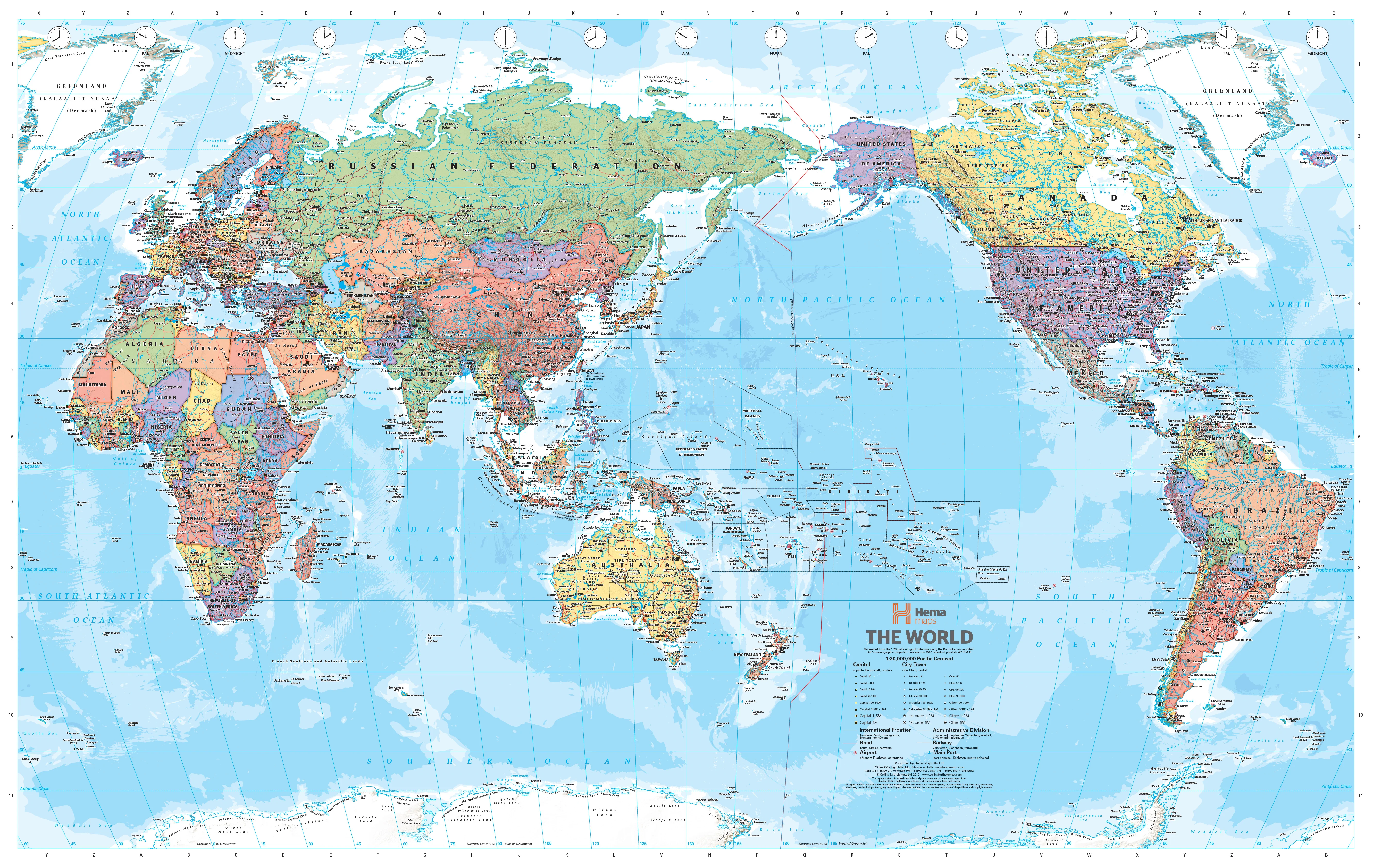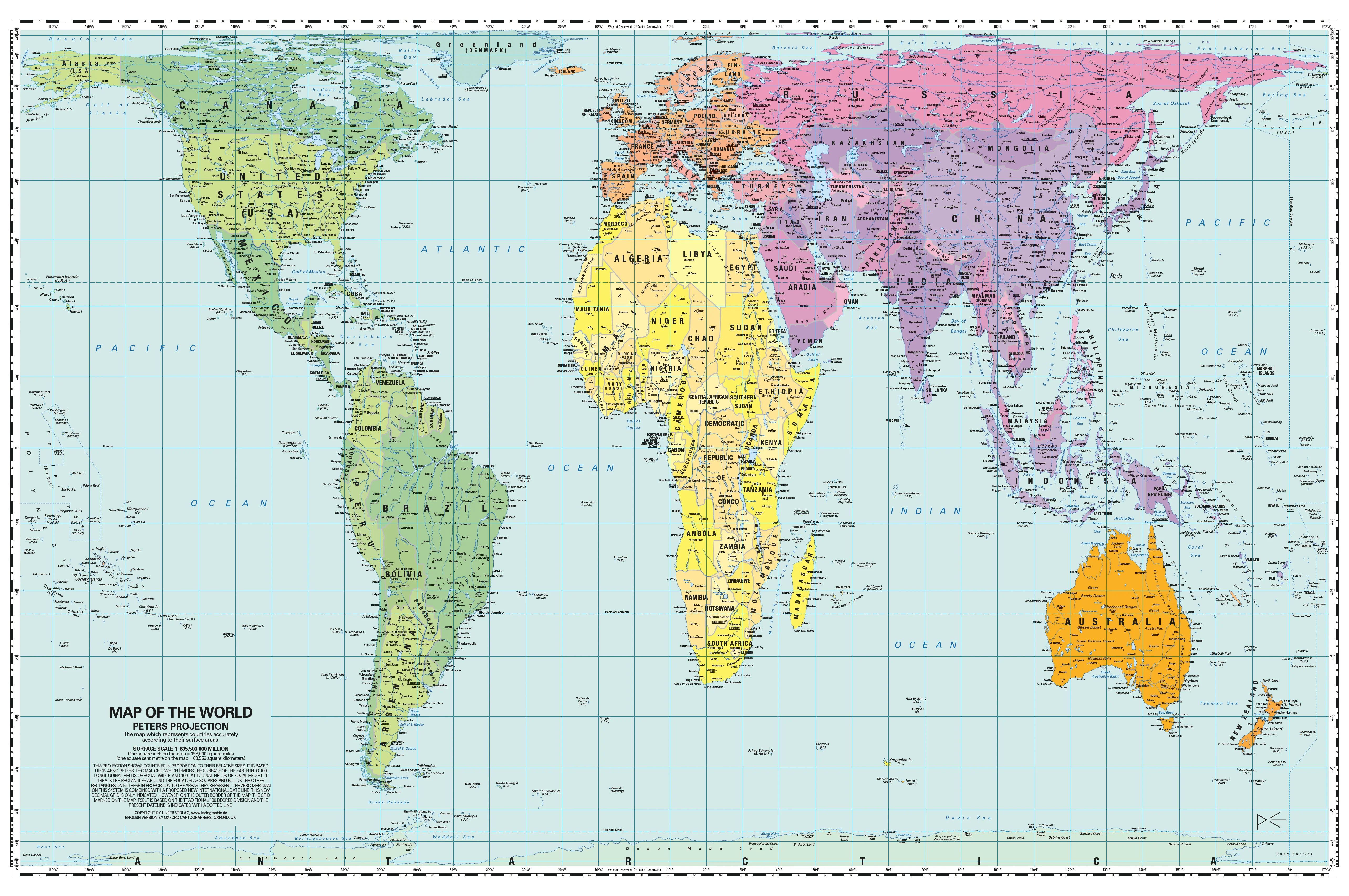
Children's Political Map of Europe 905 x 668mm
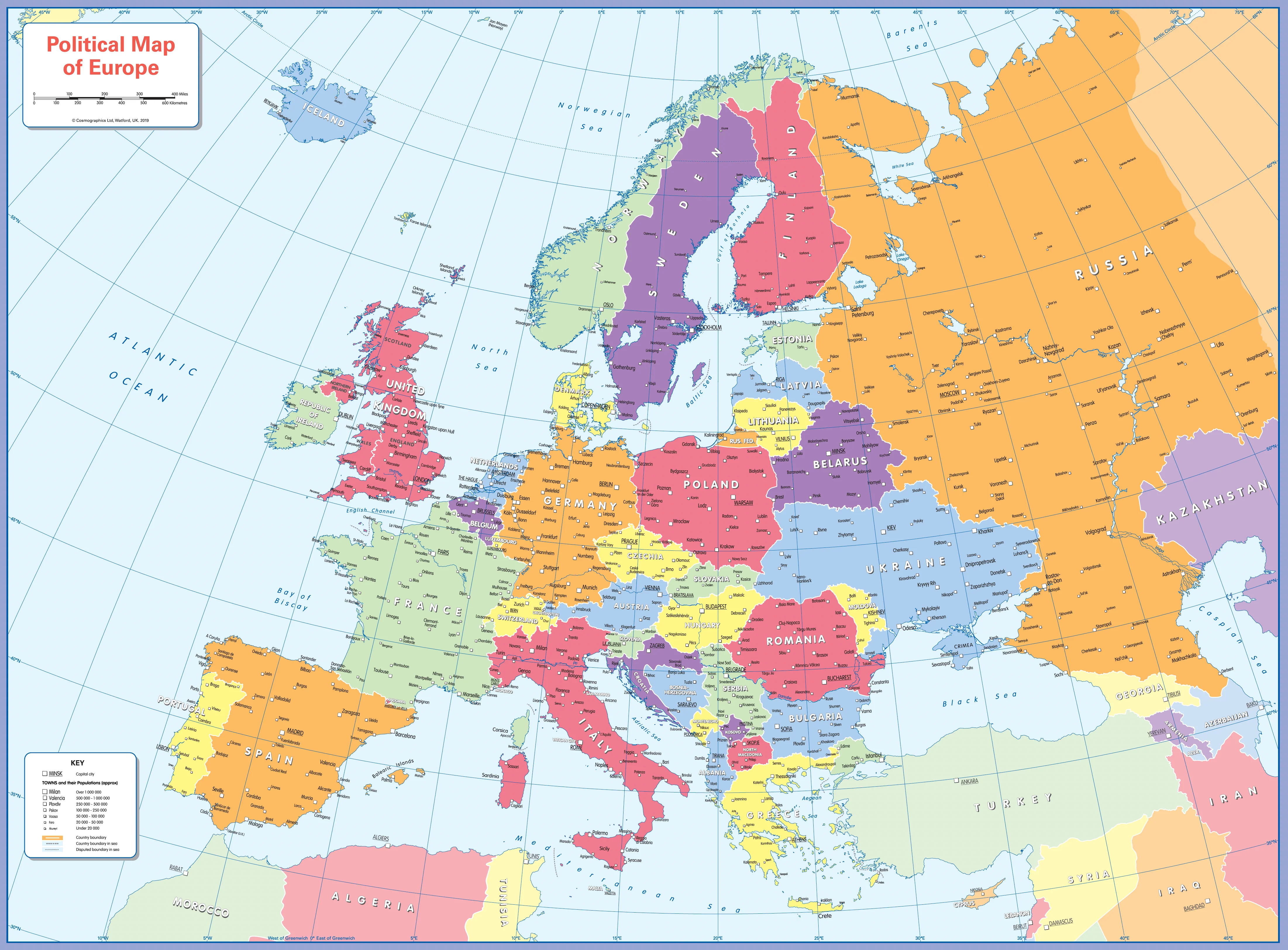
Children’s Political Map of Europe (Colour-Blind Friendly)
905 × 668 mm • Paper / Laminated / Laminated + Hang Rails / Canvas / Canvas + Hang Rails • Printed in Australia
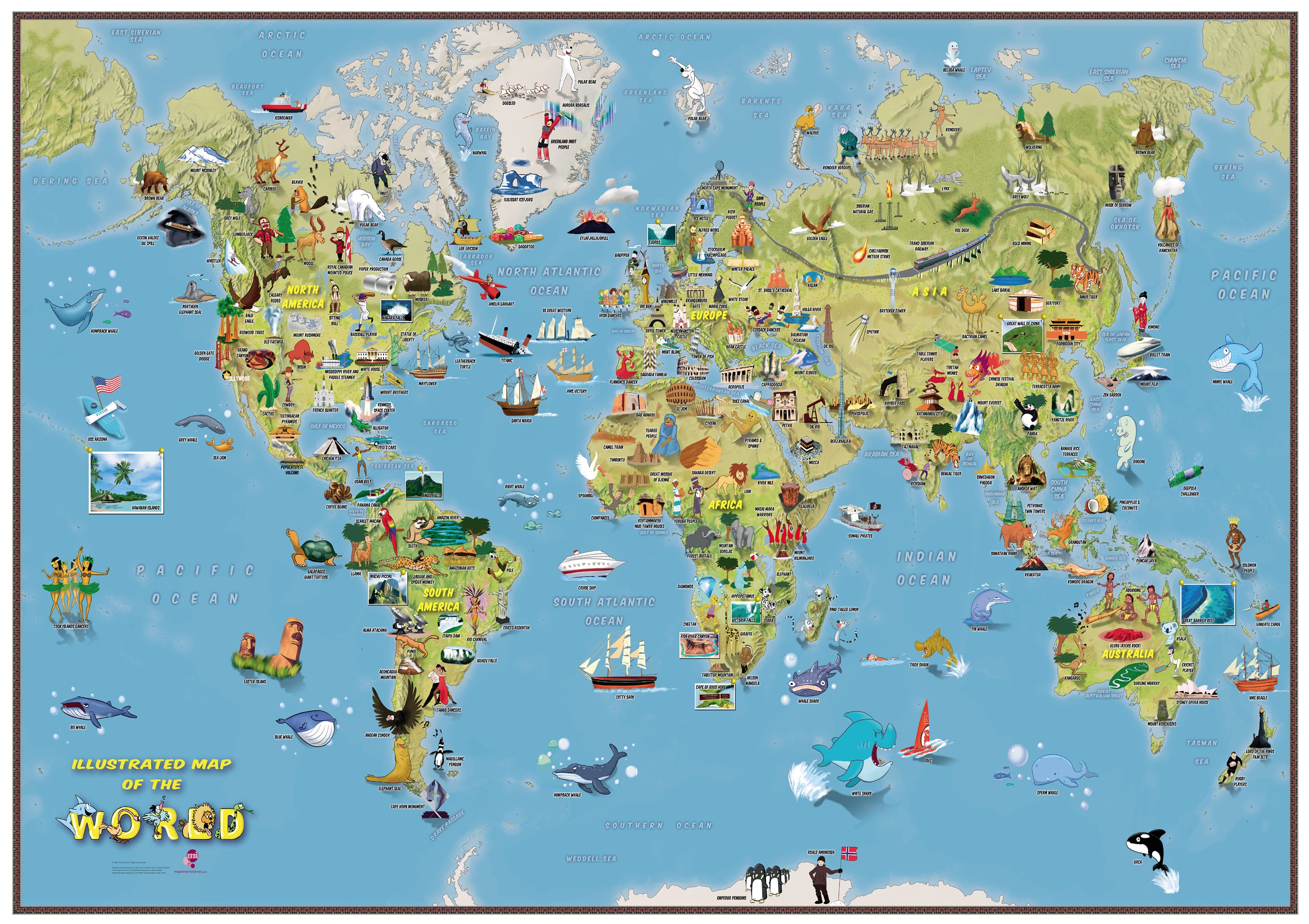
Turn curiosity into discovery. A bright, colour-blind–inclusive wall map that helps young explorers (ages 4–8) learn Europe’s countries, regions/provinces, and key cities/towns with clear labelling and a simple legend—ideal for classrooms and learning corners at home.
🌎 What Kids Learn
-
🗺️ Countries & regions: borders shown cleanly for easy recognition
-
🏙️ Cities & towns: selected major places clearly labelled
-
🧭 Map skills: compass, legend, scale awareness (1:6,500,000)
-
🧠 Memory & vocab: country names, capitals, regional terms
-
👀 Accessible design: colour-blind–friendly palette & bold, child-readable type
🧩 What’s on the Map
-
Bright, uncluttered political base with country & regional boundaries
-
Clear city/town labels sized for young readers
-
Simple legend & compass rose for guided activities
-
Balanced layout designed for classroom wall readability
🎨 Finishes & Display Options
-
📄 Paper — FSC® 160 gsm Matte-Coated
Smooth, low-glare stock ideal for framing under glass. Printed with archival Hewlett-Packard pigment inks for excellent fade resistance. -
💧 Laminated — True Encapsulation
Printed on 120 gsm and sealed in 2 × 80-micron gloss laminate (edge-sealed).
Wipe-clean • Tear-resistant • Moisture-safe — use non-permanent whiteboard markers and map dots. -
🪵 Laminated + Timber Hang Rails — Ready to Hang
Natural lacquered timber rails (top & bottom) + top hanging cord for a polished, frame-free display.
⏱️ Custom finish — please allow up to 10 working days for rail fitting. -
🖼️ Canvas — HP 395 gsm Professional Matte
Gallery-grade canvas + archival HP pigment inks for rich detail and long-term fade resistance. -
🪵 Canvas + Timber Hang Rails
Same premium canvas, finished with natural timber rails + top hanging cord — ready to hang.
⏱️ Custom finish — please allow up to 10 working days for rail fitting.
Dry-erase markers are recommended only on laminated versions.
📐 Specifications
| Attribute | Details |
|---|---|
| Title | Children’s Political Map of Europe |
| Type | Political (countries, regions/provinces, selected cities & towns) |
| Size | 905 mm (W) × 668 mm (H) |
| Scale | 1 : 6,500,000 |
| Audience | Ages 4–8 |
| Accessibility | Colour-blind–friendly palette & bold, child-readable type |
| Content | Countries, regions/provinces, cities/towns, legend, compass |
| Formats | Paper • Laminated • Laminated + Hang Rails • Canvas • Canvas + Hang Rails |
| Printing | Archival HP pigment inks (fade-resistant) |
| Paper | FSC® 160 gsm matte-coated |
| Canvas | HP 395 gsm Professional Matte |
| Publication | 2019 |
| Origin | Printed in Australia |
🧑🏫 Teaching Ideas (quick wins)
-
Find the Country: Call a country—kids point to it and name the capital.
-
Border Buddies: Pick a country; list its neighbours clockwise.
-
Direction Game: “From Madrid, go north-east—which capital do you reach?”
-
Scale Snap: Use the scale to estimate distances between two cities.
🏠 Where It Fits
Classrooms • Libraries • Playrooms • Homeschool walls • After-school programs
🧽 Care
-
Laminated: Use non-permanent whiteboard markers; wipe with a dry microfibre cloth (lightly damp if needed).
-
Paper: Frame under glass for longevity.
-
Canvas: Dust gently; avoid liquids and prolonged direct sunlight.
🤝 Our Commitment
-
Local craftsmanship: Printed and finished in Australia.
-
Sustainable materials: FSC® papers + long-life HP pigment inks to reduce waste.
-
Kid-ready clarity: Legends, colours, and label hierarchies tuned for wall readability.
-
Packed with care: Hand-checked and securely boxed to arrive clean and display-ready.
Make Europe’s countries and cities memorable for young geographers.
Choose your finish and bring political geography to life.
Original: $42.89
-65%$42.89
$15.01Product Information
Product Information
Shipping & Returns
Shipping & Returns
Description
Children’s Political Map of Europe (Colour-Blind Friendly)
905 × 668 mm • Paper / Laminated / Laminated + Hang Rails / Canvas / Canvas + Hang Rails • Printed in Australia
Turn curiosity into discovery. A bright, colour-blind–inclusive wall map that helps young explorers (ages 4–8) learn Europe’s countries, regions/provinces, and key cities/towns with clear labelling and a simple legend—ideal for classrooms and learning corners at home.
🌎 What Kids Learn
-
🗺️ Countries & regions: borders shown cleanly for easy recognition
-
🏙️ Cities & towns: selected major places clearly labelled
-
🧭 Map skills: compass, legend, scale awareness (1:6,500,000)
-
🧠 Memory & vocab: country names, capitals, regional terms
-
👀 Accessible design: colour-blind–friendly palette & bold, child-readable type
🧩 What’s on the Map
-
Bright, uncluttered political base with country & regional boundaries
-
Clear city/town labels sized for young readers
-
Simple legend & compass rose for guided activities
-
Balanced layout designed for classroom wall readability
🎨 Finishes & Display Options
-
📄 Paper — FSC® 160 gsm Matte-Coated
Smooth, low-glare stock ideal for framing under glass. Printed with archival Hewlett-Packard pigment inks for excellent fade resistance. -
💧 Laminated — True Encapsulation
Printed on 120 gsm and sealed in 2 × 80-micron gloss laminate (edge-sealed).
Wipe-clean • Tear-resistant • Moisture-safe — use non-permanent whiteboard markers and map dots. -
🪵 Laminated + Timber Hang Rails — Ready to Hang
Natural lacquered timber rails (top & bottom) + top hanging cord for a polished, frame-free display.
⏱️ Custom finish — please allow up to 10 working days for rail fitting. -
🖼️ Canvas — HP 395 gsm Professional Matte
Gallery-grade canvas + archival HP pigment inks for rich detail and long-term fade resistance. -
🪵 Canvas + Timber Hang Rails
Same premium canvas, finished with natural timber rails + top hanging cord — ready to hang.
⏱️ Custom finish — please allow up to 10 working days for rail fitting.
Dry-erase markers are recommended only on laminated versions.
📐 Specifications
| Attribute | Details |
|---|---|
| Title | Children’s Political Map of Europe |
| Type | Political (countries, regions/provinces, selected cities & towns) |
| Size | 905 mm (W) × 668 mm (H) |
| Scale | 1 : 6,500,000 |
| Audience | Ages 4–8 |
| Accessibility | Colour-blind–friendly palette & bold, child-readable type |
| Content | Countries, regions/provinces, cities/towns, legend, compass |
| Formats | Paper • Laminated • Laminated + Hang Rails • Canvas • Canvas + Hang Rails |
| Printing | Archival HP pigment inks (fade-resistant) |
| Paper | FSC® 160 gsm matte-coated |
| Canvas | HP 395 gsm Professional Matte |
| Publication | 2019 |
| Origin | Printed in Australia |
🧑🏫 Teaching Ideas (quick wins)
-
Find the Country: Call a country—kids point to it and name the capital.
-
Border Buddies: Pick a country; list its neighbours clockwise.
-
Direction Game: “From Madrid, go north-east—which capital do you reach?”
-
Scale Snap: Use the scale to estimate distances between two cities.
🏠 Where It Fits
Classrooms • Libraries • Playrooms • Homeschool walls • After-school programs
🧽 Care
-
Laminated: Use non-permanent whiteboard markers; wipe with a dry microfibre cloth (lightly damp if needed).
-
Paper: Frame under glass for longevity.
-
Canvas: Dust gently; avoid liquids and prolonged direct sunlight.
🤝 Our Commitment
-
Local craftsmanship: Printed and finished in Australia.
-
Sustainable materials: FSC® papers + long-life HP pigment inks to reduce waste.
-
Kid-ready clarity: Legends, colours, and label hierarchies tuned for wall readability.
-
Packed with care: Hand-checked and securely boxed to arrive clean and display-ready.
Make Europe’s countries and cities memorable for young geographers.
Choose your finish and bring political geography to life.