China Coast and Korea Wall Map - Published 1953 by National Geographic
Armistice Aftermath & Maritime Frontiers — China Coast & Korea Wall Map (1953)
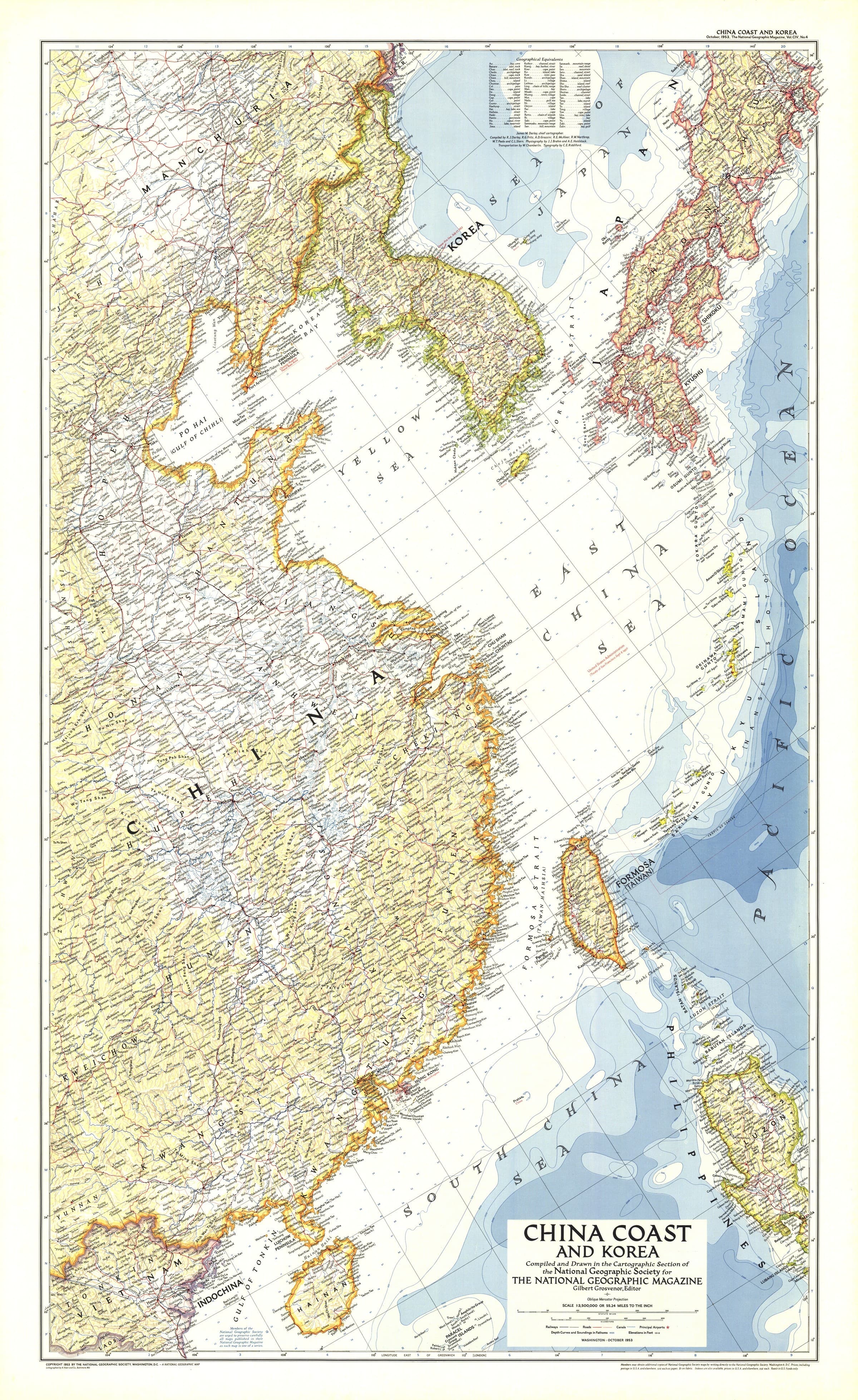
Published by National Geographic in October 1953, just months after the Korean War armistice, this sheet captures the Chinese littoral and the Korean Peninsula at a pivotal moment in modern history. Issued to accompany “Our Navy in the Far East,” it presents a crisp coastal portrait—cities and ports, islands, shorelines, and key transport corridors—rendered with the clean, authoritative cartography that defined the era.
More Than a Map – A Post-War Time Capsule
Beyond décor, this is a reference to shifting post-war realities across East Asia. It rewards close study of coastlines, settlements, and maritime approach routes, and is ideal for historians, educators, designers, naval enthusiasts, and collectors seeking a faithful 1953 vantage on the region.
Premium Materials & Finishes
🌟 Archival Paper Print
Printed on heavyweight 160gsm archival paper.
Matte surface reduces glare and keeps fine labels crisp—perfect for framing under glass.
💎 Laminated Edition
Encapsulated in two sheets of 80-micron gloss laminate (true thermal bonding, not surface film).
Wipe-clean, moisture-resistant—great for classrooms and busy reference spaces.
Optional Natural Timber Hang Rails: lacquered rails with a fitted hanging cord for a ready-to-hang finish. (Please allow up to 10 working days with hang rails.)
🏆 Museum-Quality Canvas
Printed on 395gsm HP Professional Matte Canvas for rich texture and strength.
Pigment-based, fade-resistant inks preserve deep tone and sharp typography for decades.
Optional Natural Timber Hang Rails: lacquered to highlight the grain; top cord for effortless hanging. (Please allow up to 10 working days with hang rails.)
Specifications
| Feature | Details |
|---|---|
| Title | China Coast & Korea Wall Map |
| Publisher | National Geographic |
| Original Publication | October 1953 |
| Scale | 1:3,500,000 |
| Cartographic Content | Chinese coast & Korean Peninsula; cities/ports; islands; shorelines; major transport; relief & hydrography |
| Map Size | 659 mm (W) × 1074 mm (H) |
| Available Formats | Paper, Laminated, Canvas |
| Paper Weight | 160gsm archival-quality |
| Laminate | 2 × 80-micron gloss sheets (encapsulated) |
| Canvas Weight | 395gsm HP Professional Matte Canvas |
| Inks | Pigment-based, fade-resistant |
| Optional Hang Rails | Available on Laminated & Canvas (lead time up to 10 working days) |
| Origin | Made in Australia |
Why Choose This Map
✔ Historic Snapshot: View the post-armistice (1953) coastal theatre as it was mapped at the time.
✔ Clarity & Authority: Classic National Geographic styling—balanced colour, legible labels, precise coastline.
✔ Decorative & Scholarly: Striking on the wall; richly informative up close.
✔ Archival Build: Premium substrates and inks protect contrast, labels, and linework for years to come.
Our Commitment
Printed locally in Australia, each map is colour-checked, hand-inspected, and carefully packed. From press to wall, we focus on fidelity, durability, and beauty—so your map informs, inspires, and endures.
Bring a pivotal coastline into focus. Order the China Coast & Korea Wall Map (1953) today—a faithful, display-ready classic that turns a room into a conversation.
Original: $50.05
-65%$50.05
$17.52Product Information
Product Information
Shipping & Returns
Shipping & Returns
Description
Armistice Aftermath & Maritime Frontiers — China Coast & Korea Wall Map (1953)
Published by National Geographic in October 1953, just months after the Korean War armistice, this sheet captures the Chinese littoral and the Korean Peninsula at a pivotal moment in modern history. Issued to accompany “Our Navy in the Far East,” it presents a crisp coastal portrait—cities and ports, islands, shorelines, and key transport corridors—rendered with the clean, authoritative cartography that defined the era.
More Than a Map – A Post-War Time Capsule
Beyond décor, this is a reference to shifting post-war realities across East Asia. It rewards close study of coastlines, settlements, and maritime approach routes, and is ideal for historians, educators, designers, naval enthusiasts, and collectors seeking a faithful 1953 vantage on the region.
Premium Materials & Finishes
🌟 Archival Paper Print
Printed on heavyweight 160gsm archival paper.
Matte surface reduces glare and keeps fine labels crisp—perfect for framing under glass.
💎 Laminated Edition
Encapsulated in two sheets of 80-micron gloss laminate (true thermal bonding, not surface film).
Wipe-clean, moisture-resistant—great for classrooms and busy reference spaces.
Optional Natural Timber Hang Rails: lacquered rails with a fitted hanging cord for a ready-to-hang finish. (Please allow up to 10 working days with hang rails.)
🏆 Museum-Quality Canvas
Printed on 395gsm HP Professional Matte Canvas for rich texture and strength.
Pigment-based, fade-resistant inks preserve deep tone and sharp typography for decades.
Optional Natural Timber Hang Rails: lacquered to highlight the grain; top cord for effortless hanging. (Please allow up to 10 working days with hang rails.)
Specifications
| Feature | Details |
|---|---|
| Title | China Coast & Korea Wall Map |
| Publisher | National Geographic |
| Original Publication | October 1953 |
| Scale | 1:3,500,000 |
| Cartographic Content | Chinese coast & Korean Peninsula; cities/ports; islands; shorelines; major transport; relief & hydrography |
| Map Size | 659 mm (W) × 1074 mm (H) |
| Available Formats | Paper, Laminated, Canvas |
| Paper Weight | 160gsm archival-quality |
| Laminate | 2 × 80-micron gloss sheets (encapsulated) |
| Canvas Weight | 395gsm HP Professional Matte Canvas |
| Inks | Pigment-based, fade-resistant |
| Optional Hang Rails | Available on Laminated & Canvas (lead time up to 10 working days) |
| Origin | Made in Australia |
Why Choose This Map
✔ Historic Snapshot: View the post-armistice (1953) coastal theatre as it was mapped at the time.
✔ Clarity & Authority: Classic National Geographic styling—balanced colour, legible labels, precise coastline.
✔ Decorative & Scholarly: Striking on the wall; richly informative up close.
✔ Archival Build: Premium substrates and inks protect contrast, labels, and linework for years to come.
Our Commitment
Printed locally in Australia, each map is colour-checked, hand-inspected, and carefully packed. From press to wall, we focus on fidelity, durability, and beauty—so your map informs, inspires, and endures.
Bring a pivotal coastline into focus. Order the China Coast & Korea Wall Map (1953) today—a faithful, display-ready classic that turns a room into a conversation.


