China ITMB Map
Scale: 1:3,800,000 | Size: 690 mm × 1000 mm | Waterproof & Tear-Resistant
Publisher: ITMB – International Travel Maps
🇨🇳 A Comprehensive Map of Modern China
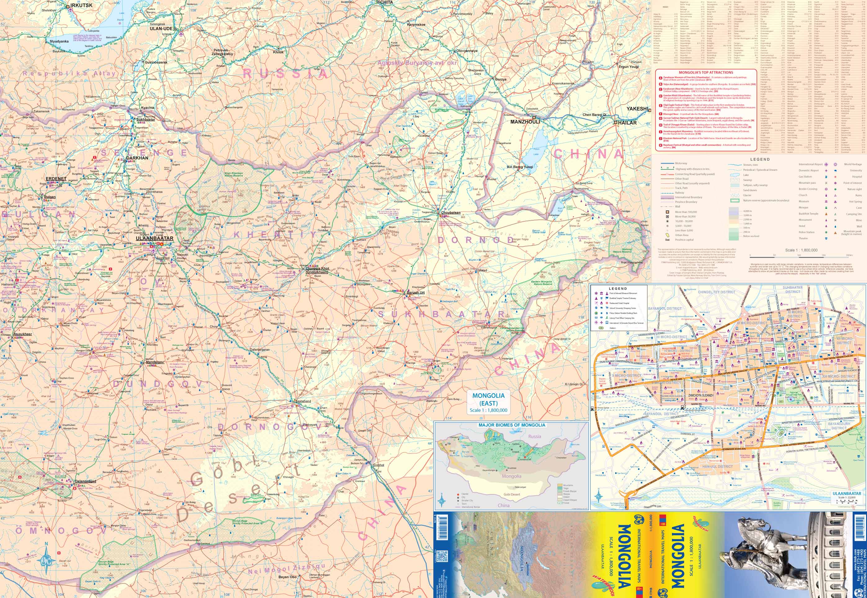
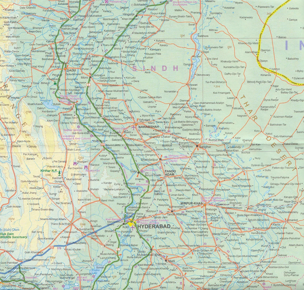
Explore the breadth of modern China with this up-to-date, waterproof edition of ITMB’s China map—designed to reflect the country’s rapidly evolving infrastructure. This detailed map includes China's vast expressway network, expansive high-speed rail system, and all the major cities, mountain ranges, rivers, and borders with accuracy and clarity.
Printed on tear-resistant synthetic paper, this map is ideal for both travel and reference—equally suited for the armchair geographer or the intrepid explorer navigating China’s landscapes firsthand.
🧭 Key Features:
-
All major roadways and motorways clearly marked, including completed and under-construction segments
-
Rapid rail lines shown in red dashed lines, reflecting China’s extensive high-speed rail network
-
Inset city maps for Beijing and Shanghai on the reverse side
-
List of Top Tourist Attractions to help guide your travels or studies
-
Mountain ranges, rivers, and lakes clearly illustrated for terrain orientation
-
All provinces, autonomous regions, and major cities labeled with English romanization
🗺️ Political Notes & Border Depictions
This map includes politically sensitive regions shown according to de facto administrative control:
-
Northeastern areas disputed with India are shown under Indian administration
-
Northwestern territories, such as Aksai Chin, are shown under Chinese control
-
Taiwan is included geographically, though ITMB takes a neutral stance on its political status
This pragmatic approach offers clarity for travelers and educators while acknowledging the complexity of geopolitical boundaries.
💧 Laminated Option Available
We offer an optional laminated version of this map, perfect for:
-
Drawing with whiteboard markers
-
Adding Map Dots to mark places visited or planned
-
Protecting the map from moisture, wear, and accidental tearing
Laminated versions are created by carefully flattening the folded map and encapsulating it in high-grade 80-micron gloss laminate. Slight fold lines may remain visible due to the original fold.
📐 Map Specifications
| Feature | Detail |
|---|---|
| Scale | 1:3,800,000 |
| Dimensions | 690 mm (W) × 1000 mm (H) |
| Format | Folded map (laminated optional) |
| Material | Waterproof synthetic paper |
| Publisher | International Travel Maps (ITMB) |
Ideal For:
✔️ Tourists visiting China’s cities or countryside
✔️ Business professionals working in regional planning or logistics
✔️ Students and educators studying modern China
✔️ Rail enthusiasts tracking high-speed lines
✔️ Map collectors and world travelers
Durable, practical, and remarkably informative—this is one of the most comprehensive maps of China in print today.
Original: $17.85
-65%$17.85
$6.25Product Information
Product Information
Shipping & Returns
Shipping & Returns
Description
Scale: 1:3,800,000 | Size: 690 mm × 1000 mm | Waterproof & Tear-Resistant
Publisher: ITMB – International Travel Maps
🇨🇳 A Comprehensive Map of Modern China
Explore the breadth of modern China with this up-to-date, waterproof edition of ITMB’s China map—designed to reflect the country’s rapidly evolving infrastructure. This detailed map includes China's vast expressway network, expansive high-speed rail system, and all the major cities, mountain ranges, rivers, and borders with accuracy and clarity.
Printed on tear-resistant synthetic paper, this map is ideal for both travel and reference—equally suited for the armchair geographer or the intrepid explorer navigating China’s landscapes firsthand.
🧭 Key Features:
-
All major roadways and motorways clearly marked, including completed and under-construction segments
-
Rapid rail lines shown in red dashed lines, reflecting China’s extensive high-speed rail network
-
Inset city maps for Beijing and Shanghai on the reverse side
-
List of Top Tourist Attractions to help guide your travels or studies
-
Mountain ranges, rivers, and lakes clearly illustrated for terrain orientation
-
All provinces, autonomous regions, and major cities labeled with English romanization
🗺️ Political Notes & Border Depictions
This map includes politically sensitive regions shown according to de facto administrative control:
-
Northeastern areas disputed with India are shown under Indian administration
-
Northwestern territories, such as Aksai Chin, are shown under Chinese control
-
Taiwan is included geographically, though ITMB takes a neutral stance on its political status
This pragmatic approach offers clarity for travelers and educators while acknowledging the complexity of geopolitical boundaries.
💧 Laminated Option Available
We offer an optional laminated version of this map, perfect for:
-
Drawing with whiteboard markers
-
Adding Map Dots to mark places visited or planned
-
Protecting the map from moisture, wear, and accidental tearing
Laminated versions are created by carefully flattening the folded map and encapsulating it in high-grade 80-micron gloss laminate. Slight fold lines may remain visible due to the original fold.
📐 Map Specifications
| Feature | Detail |
|---|---|
| Scale | 1:3,800,000 |
| Dimensions | 690 mm (W) × 1000 mm (H) |
| Format | Folded map (laminated optional) |
| Material | Waterproof synthetic paper |
| Publisher | International Travel Maps (ITMB) |
Ideal For:
✔️ Tourists visiting China’s cities or countryside
✔️ Business professionals working in regional planning or logistics
✔️ Students and educators studying modern China
✔️ Rail enthusiasts tracking high-speed lines
✔️ Map collectors and world travelers
Durable, practical, and remarkably informative—this is one of the most comprehensive maps of China in print today.