China, Journey of Rock and Water - Published 2008 by National Geographic
Physical Geography | Land Cover & Geological Story | Premium Finishes
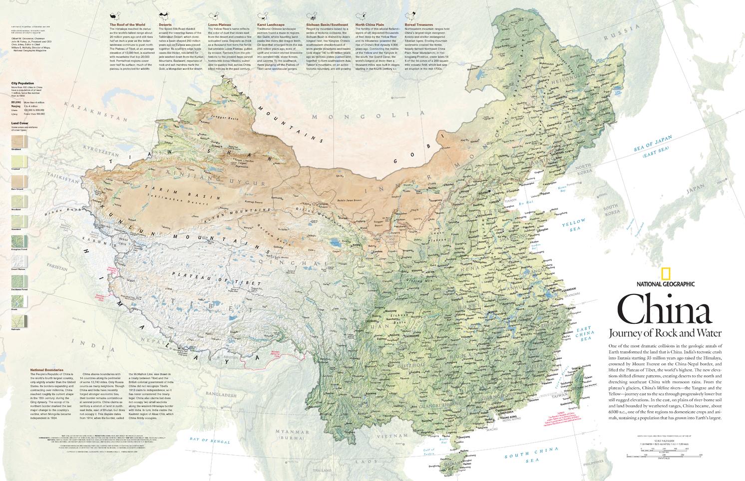
Discover the forces that shaped one of the world’s most varied landscapes with China, Journey of Rock and Water, published by National Geographic in May 2008. This detailed physical map explores the immense geological story behind modern China—where the collision of the Indian and Eurasian tectonic plates helped raise the Himalaya, lift the Tibetan Plateau, and reshape climate patterns across Asia.
The result is a map that is both scientifically rich and visually compelling. It reveals China’s extraordinary range of land cover—from forests and grasslands to croplands, deserts, and bare ground—offering a vivid portrait of a country shaped by uplift, erosion, monsoon systems, and deep geological time.
Issued as one half of a two-map set alongside “The Forbidden City,” this edition is an excellent wall reference for anyone interested in geology, physical geography, environmental change, and the natural history of China.
🗺️ Features & Highlights
-
A striking physical map of China focused on geology, terrain, and land cover
-
Shows the immense influence of the India–Eurasia tectonic collision on the formation of the Himalaya and Tibetan Plateau
-
Highlights a broad range of land-cover types, including:
-
Forests
-
Grasslands
-
Row crops
-
Bare ground
-
Deserts
-
and more
-
-
Helps explain how uplift and changing elevation altered climate patterns, contributing to:
-
arid northern deserts
-
monsoon rainfall in southeastern China
-
-
Published as part of a two-map set, paired with “The Forbidden City”
-
A superb resource for classrooms, libraries, studies, and anyone fascinated by Earth systems
✨ Available Finishes
| Format | Description |
|---|---|
| 📜 Paper (160 gsm) | Heavyweight matte-coated paper—perfect for framing under glass. |
| 🧼 Laminated (Encapsulated) | Fully sealed in 80-micron gloss laminate for a durable, wipe-clean surface. |
| 🪵 Laminated with Wooden Hang Rails | Laminated map mounted with lacquered natural timber rails (top & bottom) and a hanging cord—ready to display. |
| 🖼️ Canvas (395 gsm) | HP Professional Matte Canvas with archival pigment inks—rich texture, fade-resistant, gallery quality. |
| 🪵 Canvas with Wooden Hang Rails | Canvas mounted with timber rails and hanging cord—timeless, ready-to-display finish. |
🔨 Note: Hang-railed maps are professionally mounted—please allow up to 10 working days.
📐 Specifications
| Feature | Detail |
|---|---|
| Title | China, Journey of Rock and Water |
| Publisher | National Geographic |
| Published | 2008 |
| Scale | 1:8,250,000 |
| Page Size | 789 mm (W) × 510 mm (H) |
| Map Type | Physical / Geological / Land Cover Reference |
| Materials | Paper, Laminated, Canvas, with or without Timber Rails |
| Printing | Pigment-based, fade-resistant inks |
| Made In | Australia |
🎁 Perfect For
-
Students and educators studying geology, climate, and Asian geography
-
Collectors of National Geographic science and physical maps
-
Libraries, classrooms, and offices needing a visually engaging Earth-science reference
-
Home décor with an intellectual, natural-history focus
-
Gift-giving for geographers, geologists, and map enthusiasts
🚚 Delivery
-
Paper, Laminated, Canvas (rolled): Typically ship within 1–2 business days
-
Hang-Railed Maps: Made to order—please allow up to 10 working days
-
Protective Packaging: Securely packed to arrive in pristine condition
Bring the immense geological drama of China to your wall with this beautifully informative 2008 National Geographic edition—a map of uplift, climate, and landscape on a continental scale.
Original: $57.20
-65%$57.20
$20.02Product Information
Product Information
Shipping & Returns
Shipping & Returns
Description
Physical Geography | Land Cover & Geological Story | Premium Finishes
Discover the forces that shaped one of the world’s most varied landscapes with China, Journey of Rock and Water, published by National Geographic in May 2008. This detailed physical map explores the immense geological story behind modern China—where the collision of the Indian and Eurasian tectonic plates helped raise the Himalaya, lift the Tibetan Plateau, and reshape climate patterns across Asia.
The result is a map that is both scientifically rich and visually compelling. It reveals China’s extraordinary range of land cover—from forests and grasslands to croplands, deserts, and bare ground—offering a vivid portrait of a country shaped by uplift, erosion, monsoon systems, and deep geological time.
Issued as one half of a two-map set alongside “The Forbidden City,” this edition is an excellent wall reference for anyone interested in geology, physical geography, environmental change, and the natural history of China.
🗺️ Features & Highlights
-
A striking physical map of China focused on geology, terrain, and land cover
-
Shows the immense influence of the India–Eurasia tectonic collision on the formation of the Himalaya and Tibetan Plateau
-
Highlights a broad range of land-cover types, including:
-
Forests
-
Grasslands
-
Row crops
-
Bare ground
-
Deserts
-
and more
-
-
Helps explain how uplift and changing elevation altered climate patterns, contributing to:
-
arid northern deserts
-
monsoon rainfall in southeastern China
-
-
Published as part of a two-map set, paired with “The Forbidden City”
-
A superb resource for classrooms, libraries, studies, and anyone fascinated by Earth systems
✨ Available Finishes
| Format | Description |
|---|---|
| 📜 Paper (160 gsm) | Heavyweight matte-coated paper—perfect for framing under glass. |
| 🧼 Laminated (Encapsulated) | Fully sealed in 80-micron gloss laminate for a durable, wipe-clean surface. |
| 🪵 Laminated with Wooden Hang Rails | Laminated map mounted with lacquered natural timber rails (top & bottom) and a hanging cord—ready to display. |
| 🖼️ Canvas (395 gsm) | HP Professional Matte Canvas with archival pigment inks—rich texture, fade-resistant, gallery quality. |
| 🪵 Canvas with Wooden Hang Rails | Canvas mounted with timber rails and hanging cord—timeless, ready-to-display finish. |
🔨 Note: Hang-railed maps are professionally mounted—please allow up to 10 working days.
📐 Specifications
| Feature | Detail |
|---|---|
| Title | China, Journey of Rock and Water |
| Publisher | National Geographic |
| Published | 2008 |
| Scale | 1:8,250,000 |
| Page Size | 789 mm (W) × 510 mm (H) |
| Map Type | Physical / Geological / Land Cover Reference |
| Materials | Paper, Laminated, Canvas, with or without Timber Rails |
| Printing | Pigment-based, fade-resistant inks |
| Made In | Australia |
🎁 Perfect For
-
Students and educators studying geology, climate, and Asian geography
-
Collectors of National Geographic science and physical maps
-
Libraries, classrooms, and offices needing a visually engaging Earth-science reference
-
Home décor with an intellectual, natural-history focus
-
Gift-giving for geographers, geologists, and map enthusiasts
🚚 Delivery
-
Paper, Laminated, Canvas (rolled): Typically ship within 1–2 business days
-
Hang-Railed Maps: Made to order—please allow up to 10 working days
-
Protective Packaging: Securely packed to arrive in pristine condition
Bring the immense geological drama of China to your wall with this beautifully informative 2008 National Geographic edition—a map of uplift, climate, and landscape on a continental scale.


