City Characteristics: A Diverse Urban Landscape - Atlas of the World, 10th Edition by National Geographic
City Characteristics: A Diverse Urban Landscape - Atlas of the World, 10th Edition by National Geographic
National Geographic | 711 × 559 mm | Published 25 February 2015
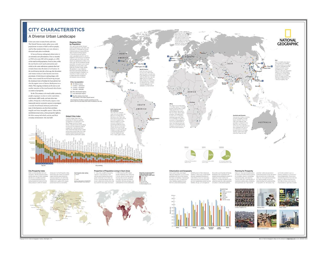
Explore the changing shape of the modern city with City Characteristics: A Diverse Urban Landscape, a thought-provoking thematic map plate from the 10th Edition of the National Geographic Atlas of the World. This visually rich reference examines how cities grow, function, and prosper, revealing the striking contrasts and common pressures that define urban life across the globe.
Rather than focusing on one country or region, this plate takes a global urban perspective—mapping population concentration, prosperity, inequality, and the geographic forces shaping cities in the 21st century. It is an outstanding resource for classrooms, libraries, planners, students, and anyone interested in the future of urban life.
🗺️ Features & Highlights
-
Mapping Cities by Population
Visualises the scale and distribution of urban populations across the world, highlighting the rise of major metropolitan centres. -
Global Cities Index
Examines the relative influence and importance of leading cities within the global network of trade, finance, culture, and governance. -
City Prosperity Index
Offers insight into how cities compare in terms of development, opportunity, and quality of life. -
Proportion of Population Living in Slum Areas
Presents a powerful picture of urban inequality and the challenges faced by rapidly growing cities. -
Urbanization and Geography
Explores how landforms, location, climate, and infrastructure affect the form and function of cities. -
Planning for Prosperity
Highlights the need for thoughtful urban planning in shaping more sustainable and equitable futures. -
A superb example of National Geographic’s thematic cartography, combining complex urban data with elegant design and strong readability.
✨ Available Finishes
| Format | Description |
|---|---|
| 📜 Paper (160 gsm) | Heavyweight matte-coated paper—perfect for framing under glass. |
| 🧼 Laminated (Encapsulated) | Fully sealed in 80-micron gloss laminate for a durable, wipe-clean surface. |
| 🪵 Laminated with Wooden Hang Rails | Laminated map mounted with lacquered natural timber rails (top & bottom) and a hanging cord—ready to display. |
| 🖼️ Canvas (395 gsm) | HP Professional Matte Canvas with archival pigment inks—rich texture, fade-resistant, gallery quality. |
| 🪵 Canvas with Wooden Hang Rails | Canvas mounted with timber rails and hanging cord—timeless, ready-to-display finish. |
🔨 Note: Hang-railed maps are professionally mounted—please allow up to 10 working days.
📐 Specifications
| Feature | Detail |
|---|---|
| Title | City Characteristics: A Diverse Urban Landscape |
| Publisher | National Geographic |
| Source | Atlas of the World, 10th Edition |
| Plate Number | 16 |
| Published | 25 February 2015 |
| Page Size | 711 mm (W) × 559 mm (H) |
| Map Type | Thematic / Urban Geography Reference |
| Tags | Mapping Cities by Population, Global Cities Index, City Prosperity Index, Proportion of Population Living in Slum Areas, Urbanization and Geography, Planning for Prosperity |
| Materials | Paper, Laminated, Canvas, with or without Timber Rails |
| Printing | Pigment-based, fade-resistant inks |
| Made In | Australia |
🎁 Perfect For
-
Geography, planning, and urban studies classrooms
-
Libraries and universities needing a strong thematic wall reference
-
Architects, planners, and policy professionals interested in the structure of cities
-
Collectors of National Geographic atlas plates
-
Home and office décor with an intellectual, global focus
🚚 Delivery
-
Paper, Laminated, Canvas (rolled): Typically ship within 1–2 business days
-
Hang-Railed Maps: Made to order—please allow up to 10 working days
-
Protective Packaging: Securely packed to arrive in pristine condition
Bring the complexity and energy of the world’s cities to your wall with this insightful National Geographic atlas plate—a compelling visual guide to how urban life is shaped, measured, and imagined.
Original: $57.20
-65%$57.20
$20.02Product Information
Product Information
Shipping & Returns
Shipping & Returns
Description
National Geographic | 711 × 559 mm | Published 25 February 2015
Explore the changing shape of the modern city with City Characteristics: A Diverse Urban Landscape, a thought-provoking thematic map plate from the 10th Edition of the National Geographic Atlas of the World. This visually rich reference examines how cities grow, function, and prosper, revealing the striking contrasts and common pressures that define urban life across the globe.
Rather than focusing on one country or region, this plate takes a global urban perspective—mapping population concentration, prosperity, inequality, and the geographic forces shaping cities in the 21st century. It is an outstanding resource for classrooms, libraries, planners, students, and anyone interested in the future of urban life.
🗺️ Features & Highlights
-
Mapping Cities by Population
Visualises the scale and distribution of urban populations across the world, highlighting the rise of major metropolitan centres. -
Global Cities Index
Examines the relative influence and importance of leading cities within the global network of trade, finance, culture, and governance. -
City Prosperity Index
Offers insight into how cities compare in terms of development, opportunity, and quality of life. -
Proportion of Population Living in Slum Areas
Presents a powerful picture of urban inequality and the challenges faced by rapidly growing cities. -
Urbanization and Geography
Explores how landforms, location, climate, and infrastructure affect the form and function of cities. -
Planning for Prosperity
Highlights the need for thoughtful urban planning in shaping more sustainable and equitable futures. -
A superb example of National Geographic’s thematic cartography, combining complex urban data with elegant design and strong readability.
✨ Available Finishes
| Format | Description |
|---|---|
| 📜 Paper (160 gsm) | Heavyweight matte-coated paper—perfect for framing under glass. |
| 🧼 Laminated (Encapsulated) | Fully sealed in 80-micron gloss laminate for a durable, wipe-clean surface. |
| 🪵 Laminated with Wooden Hang Rails | Laminated map mounted with lacquered natural timber rails (top & bottom) and a hanging cord—ready to display. |
| 🖼️ Canvas (395 gsm) | HP Professional Matte Canvas with archival pigment inks—rich texture, fade-resistant, gallery quality. |
| 🪵 Canvas with Wooden Hang Rails | Canvas mounted with timber rails and hanging cord—timeless, ready-to-display finish. |
🔨 Note: Hang-railed maps are professionally mounted—please allow up to 10 working days.
📐 Specifications
| Feature | Detail |
|---|---|
| Title | City Characteristics: A Diverse Urban Landscape |
| Publisher | National Geographic |
| Source | Atlas of the World, 10th Edition |
| Plate Number | 16 |
| Published | 25 February 2015 |
| Page Size | 711 mm (W) × 559 mm (H) |
| Map Type | Thematic / Urban Geography Reference |
| Tags | Mapping Cities by Population, Global Cities Index, City Prosperity Index, Proportion of Population Living in Slum Areas, Urbanization and Geography, Planning for Prosperity |
| Materials | Paper, Laminated, Canvas, with or without Timber Rails |
| Printing | Pigment-based, fade-resistant inks |
| Made In | Australia |
🎁 Perfect For
-
Geography, planning, and urban studies classrooms
-
Libraries and universities needing a strong thematic wall reference
-
Architects, planners, and policy professionals interested in the structure of cities
-
Collectors of National Geographic atlas plates
-
Home and office décor with an intellectual, global focus
🚚 Delivery
-
Paper, Laminated, Canvas (rolled): Typically ship within 1–2 business days
-
Hang-Railed Maps: Made to order—please allow up to 10 working days
-
Protective Packaging: Securely packed to arrive in pristine condition
Bring the complexity and energy of the world’s cities to your wall with this insightful National Geographic atlas plate—a compelling visual guide to how urban life is shaped, measured, and imagined.


