Close-up USA, Illinois, Indiana, Ohio, Kentucky - Published 1977 by National Geographic
Historic Regional Map | Great Lakes to the Ohio Valley | Large Wall Format (887 × 572 mm) | Premium Finishes
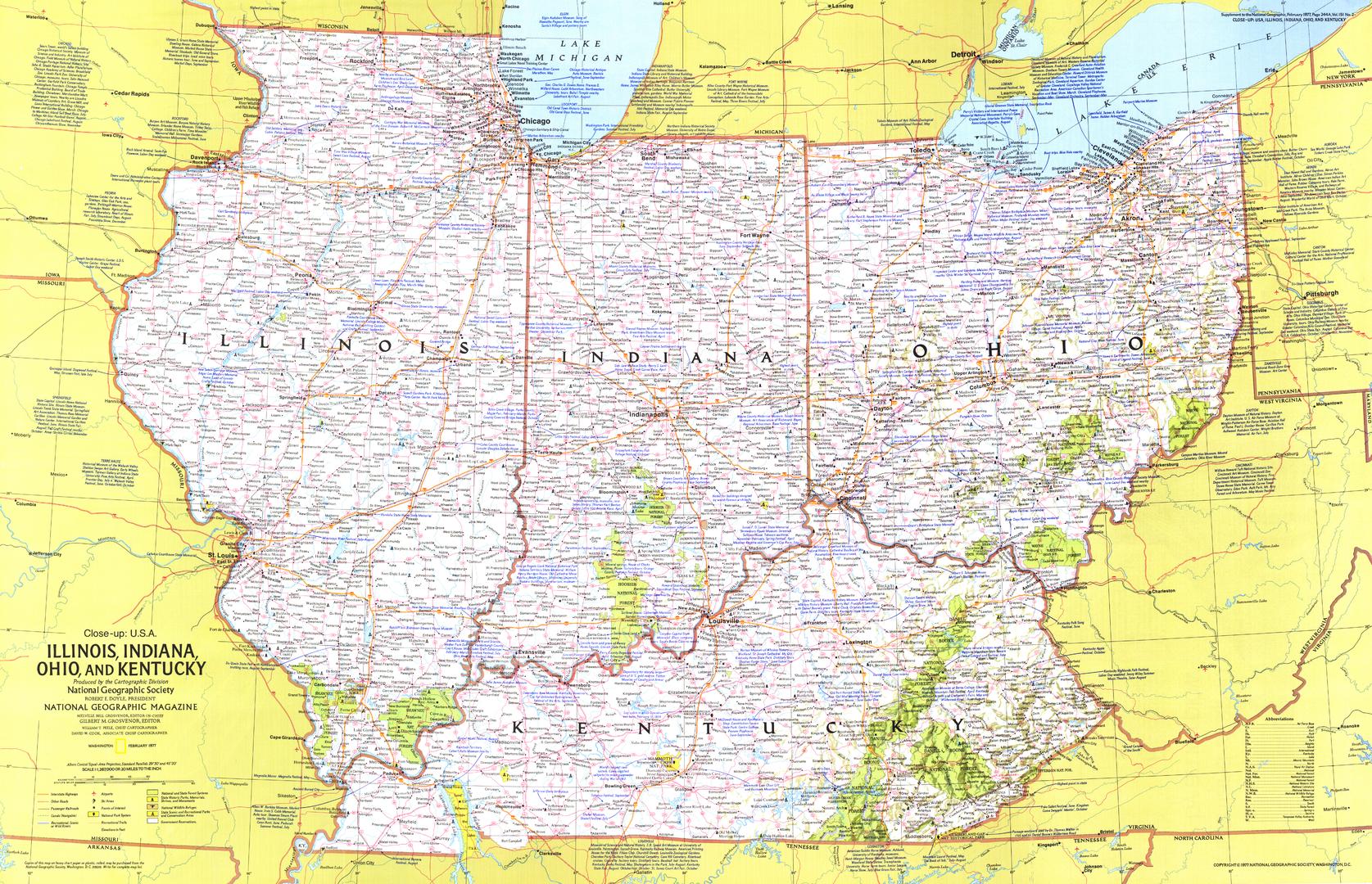
A richly detailed regional map capturing the heart of the American Midwest, this 1977 publication from National Geographic presents Illinois, Indiana, Ohio, and Kentucky with the clarity and visual balance that define the magazine’s classic cartography.
Part of the celebrated Close-up: U.S.A. series, this map focuses on a region shaped by industry, rivers, and innovation—stretching from the shores of the Great Lakes to the rolling hills of Kentucky. It offers a compelling snapshot of the landscape, infrastructure, and cultural geography of the late 20th century.
This is more than a map—it’s a window into a defining region of American history and identity.
Why This Map Stands Out
A focused regional perspective
Zooms in on four key states, offering far greater detail than broader national maps.
Classic National Geographic cartography
Clean typography, balanced colour, and precise labelling ensure clarity and visual appeal.
A snapshot of 1970s America
Captures infrastructure, cities, and geography as they appeared in the late 20th century.
Part of the iconic Close-up U.S.A. series
A collectible piece from one of National Geographic’s most respected map series.
Strong visual and historical appeal
Works equally well as a research reference or a decorative statement.
🗺️ What the Map Shows
- Detailed coverage of Illinois, Indiana, Ohio, and Kentucky
- Major cities including Chicago, Indianapolis, Columbus, Cincinnati, Cleveland, and Louisville
- Road networks, rivers, and regional infrastructure of the era
- The Great Lakes shoreline and inland river systems such as the Ohio River
- A geographic view connecting industrial centres, agricultural regions, and historic towns
- A layout designed for both navigation and regional understanding
📐 Size & Format
887 mm (W) × 572 mm (H)
Landscape orientation
A versatile wall size offering strong readability without overwhelming the space—ideal for:
- Home offices and studies
- Classrooms and history displays
- Libraries and research environments
- Americana or travel-themed interiors
✨ Premium Finishes
| Format | Description |
|---|---|
| 📜 Paper (160 gsm) | Heavyweight matte-coated paper—ideal for framing. Preserves crisp detail and vintage tones. |
| 🧼 Laminated (Encapsulated) | Sealed in 2 × 80-micron gloss laminate. Durable, wipe-clean, and suitable for frequent use. |
| 🪵 Laminated + Timber Hang Rails | Laminated map mounted with lacquered natural timber rails and hanging cord—ready to display. |
| 🖼️ Canvas (395 gsm HP Professional Matte) | Printed with archival pigment inks. Rich texture enhances the classic cartographic style. |
| 🪵 Canvas + Timber Hang Rails | Canvas paired with timber rails for a refined, gallery-style presentation. |
🔨 Please allow up to 10 working days for professionally mounted hang-railed finishes.
📊 Specifications
| Feature | Detail |
|---|---|
| Title | Close-up U.S.A. — Illinois, Indiana, Ohio & Kentucky |
| Publisher | National Geographic |
| Published | 1977 |
| Scale | 1:1,267,000 |
| Dimensions | 887 mm × 572 mm |
| Orientation | Landscape |
| Map Type | Regional / Historical |
| Series | Close-up: U.S.A. |
| Materials | 160 gsm matte paper / 2 × 80-micron laminate / 395 gsm HP Professional Matte Canvas |
| Printing | Pigment-based, fade-resistant inks |
| Origin | Printed in Australia |
🎯 Ideal For
- Collectors of National Geographic and historical maps
- Enthusiasts of American history and regional geography
- Educators teaching U.S. geography or cultural history
- Offices and interiors seeking a classic Americana aesthetic
- Gift buyers looking for a meaningful, location-specific map
🇺🇸 A Region of Innovation and Heritage
This region tells a powerful American story:
- The birthplace of Abraham Lincoln
- Home to aviation pioneers Wilbur Wright and Orville Wright
- Linked to space exploration through figures like Neil Armstrong and John Glenn
From river trade routes to industrial cities and agricultural heartlands, this map captures a region that helped shape modern America.
🤝 Our Commitment
- Printed in Australia using archival-quality production
- Faithful reproduction of original colours and cartographic detail
- Premium materials selected for durability and longevity
- Each map is hand-checked before dispatch
- Carefully packaged for safe delivery
🚚 Delivery
- Paper, Laminated, Canvas (rolled): Dispatch within 1–2 business days
- Hang-Railed Maps: Made to order—allow up to 10 working days
- Packaging: Securely rolled in protective tubing
Step into the geography and history of America’s Midwest—
a map that captures both place and legacy.
👉 Order now and own a classic piece of National Geographic cartography.
Product Information
Product Information
Shipping & Returns
Shipping & Returns
Description
Historic Regional Map | Great Lakes to the Ohio Valley | Large Wall Format (887 × 572 mm) | Premium Finishes
A richly detailed regional map capturing the heart of the American Midwest, this 1977 publication from National Geographic presents Illinois, Indiana, Ohio, and Kentucky with the clarity and visual balance that define the magazine’s classic cartography.
Part of the celebrated Close-up: U.S.A. series, this map focuses on a region shaped by industry, rivers, and innovation—stretching from the shores of the Great Lakes to the rolling hills of Kentucky. It offers a compelling snapshot of the landscape, infrastructure, and cultural geography of the late 20th century.
This is more than a map—it’s a window into a defining region of American history and identity.
Why This Map Stands Out
A focused regional perspective
Zooms in on four key states, offering far greater detail than broader national maps.
Classic National Geographic cartography
Clean typography, balanced colour, and precise labelling ensure clarity and visual appeal.
A snapshot of 1970s America
Captures infrastructure, cities, and geography as they appeared in the late 20th century.
Part of the iconic Close-up U.S.A. series
A collectible piece from one of National Geographic’s most respected map series.
Strong visual and historical appeal
Works equally well as a research reference or a decorative statement.
🗺️ What the Map Shows
- Detailed coverage of Illinois, Indiana, Ohio, and Kentucky
- Major cities including Chicago, Indianapolis, Columbus, Cincinnati, Cleveland, and Louisville
- Road networks, rivers, and regional infrastructure of the era
- The Great Lakes shoreline and inland river systems such as the Ohio River
- A geographic view connecting industrial centres, agricultural regions, and historic towns
- A layout designed for both navigation and regional understanding
📐 Size & Format
887 mm (W) × 572 mm (H)
Landscape orientation
A versatile wall size offering strong readability without overwhelming the space—ideal for:
- Home offices and studies
- Classrooms and history displays
- Libraries and research environments
- Americana or travel-themed interiors
✨ Premium Finishes
| Format | Description |
|---|---|
| 📜 Paper (160 gsm) | Heavyweight matte-coated paper—ideal for framing. Preserves crisp detail and vintage tones. |
| 🧼 Laminated (Encapsulated) | Sealed in 2 × 80-micron gloss laminate. Durable, wipe-clean, and suitable for frequent use. |
| 🪵 Laminated + Timber Hang Rails | Laminated map mounted with lacquered natural timber rails and hanging cord—ready to display. |
| 🖼️ Canvas (395 gsm HP Professional Matte) | Printed with archival pigment inks. Rich texture enhances the classic cartographic style. |
| 🪵 Canvas + Timber Hang Rails | Canvas paired with timber rails for a refined, gallery-style presentation. |
🔨 Please allow up to 10 working days for professionally mounted hang-railed finishes.
📊 Specifications
| Feature | Detail |
|---|---|
| Title | Close-up U.S.A. — Illinois, Indiana, Ohio & Kentucky |
| Publisher | National Geographic |
| Published | 1977 |
| Scale | 1:1,267,000 |
| Dimensions | 887 mm × 572 mm |
| Orientation | Landscape |
| Map Type | Regional / Historical |
| Series | Close-up: U.S.A. |
| Materials | 160 gsm matte paper / 2 × 80-micron laminate / 395 gsm HP Professional Matte Canvas |
| Printing | Pigment-based, fade-resistant inks |
| Origin | Printed in Australia |
🎯 Ideal For
- Collectors of National Geographic and historical maps
- Enthusiasts of American history and regional geography
- Educators teaching U.S. geography or cultural history
- Offices and interiors seeking a classic Americana aesthetic
- Gift buyers looking for a meaningful, location-specific map
🇺🇸 A Region of Innovation and Heritage
This region tells a powerful American story:
- The birthplace of Abraham Lincoln
- Home to aviation pioneers Wilbur Wright and Orville Wright
- Linked to space exploration through figures like Neil Armstrong and John Glenn
From river trade routes to industrial cities and agricultural heartlands, this map captures a region that helped shape modern America.
🤝 Our Commitment
- Printed in Australia using archival-quality production
- Faithful reproduction of original colours and cartographic detail
- Premium materials selected for durability and longevity
- Each map is hand-checked before dispatch
- Carefully packaged for safe delivery
🚚 Delivery
- Paper, Laminated, Canvas (rolled): Dispatch within 1–2 business days
- Hang-Railed Maps: Made to order—allow up to 10 working days
- Packaging: Securely rolled in protective tubing
Step into the geography and history of America’s Midwest—
a map that captures both place and legacy.
👉 Order now and own a classic piece of National Geographic cartography.


