Close-up USA, Maine - Published 1975 by National Geographic
Historic Regional Map | New England to Atlantic Canada | Large Wall Format (890 × 577 mm) | Premium Finishes
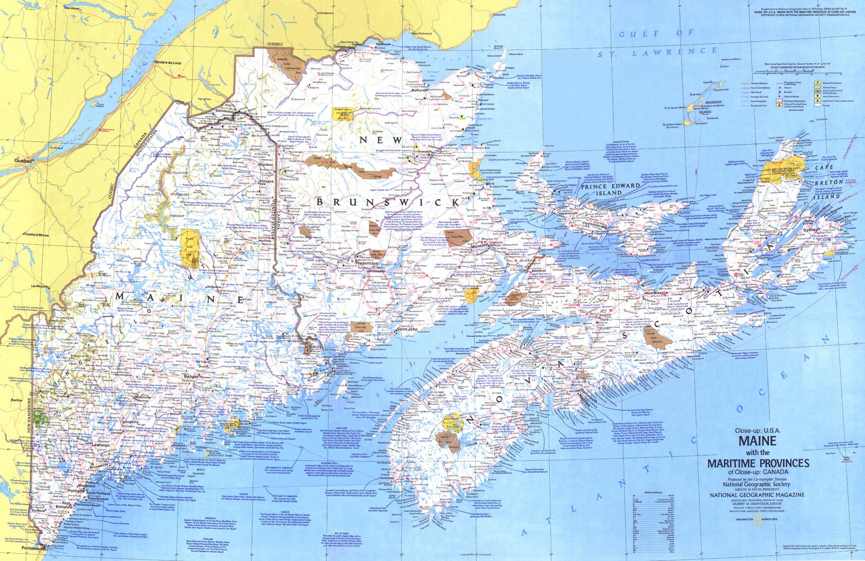
A beautifully detailed regional map capturing the rugged coastline and maritime culture of the northeastern United States and Atlantic Canada. Published by National Geographic in 1975, this Close-up: U.S.A. edition focuses on Maine and the neighbouring Canadian provinces—New Brunswick, Nova Scotia, and Prince Edward Island—presenting the region with clarity, character, and classic cartographic style.
From rocky headlands and fishing harbours to inland forests and historic towns, this map offers a rich snapshot of a region defined by ocean, heritage, and seasonal travel.
Why This Map Stands Out
A coastal region in full detail
Zooms in on Maine and the Canadian Maritimes—revealing far more detail than broader national maps.
Classic National Geographic design
Clean typography, balanced colour, and precise labelling deliver both readability and visual appeal.
A travel-era snapshot of 1975
Captures the region’s roads, towns, and attractions as they appeared in the mid-20th century.
Part of the Close-up U.S.A. series
A collectible map from one of National Geographic’s most respected regional series.
Rich with travel context
Includes notes on festivals, events, and historical sites—bringing the map to life beyond geography.
🗺️ What the Map Shows
- Detailed coverage of Maine and the surrounding Canadian provinces
- Coastal geography including the Gulf of Maine, bays, islands, and harbours
- Major towns and cities across New England and Atlantic Canada
- Road networks and regional connections of the era
- Locations of historic sites, festivals, and points of interest
- A geographic framework linking the U.S. Northeast with the Canadian Maritimes
📐 Size & Format
890 mm (W) × 577 mm (H)
Landscape orientation
A versatile wall size that offers strong readability—ideal for:
- Home offices and studies
- Travel-themed interiors
- Classrooms and history displays
- Coastal or maritime-inspired spaces
✨ Premium Finishes
| Format | Description |
|---|---|
| 📜 Paper (160 gsm) | Heavyweight matte-coated paper—ideal for framing. Preserves fine detail and vintage tones. |
| 🧼 Laminated (Encapsulated) | Sealed in 2 × 80-micron gloss laminate. Durable, wipe-clean, and suitable for frequent use. |
| 🪵 Laminated + Timber Hang Rails | Laminated map mounted with lacquered natural timber rails and hanging cord—ready to display. |
| 🖼️ Canvas (395 gsm HP Professional Matte) | Printed with archival pigment inks. Rich texture enhances the classic cartographic style. |
| 🪵 Canvas + Timber Hang Rails | Canvas paired with timber rails for a refined, gallery-style presentation. |
🔨 Please allow up to 10 working days for professionally mounted hang-railed finishes.
📊 Specifications
| Feature | Detail |
|---|---|
| Title | Close-up U.S.A. — Maine & the Canadian Maritimes |
| Publisher | National Geographic |
| Published | 1975 |
| Scale | 1:1,050,000 |
| Dimensions | 890 mm × 577 mm |
| Orientation | Landscape |
| Map Type | Regional / Historical / Political |
| Coverage | Maine, New Brunswick, Nova Scotia, Prince Edward Island |
| Series | Close-up: U.S.A. |
| Materials | 160 gsm matte paper / 2 × 80-micron laminate / 395 gsm HP Professional Matte Canvas |
| Printing | Pigment-based, fade-resistant inks |
| Origin | Printed in Australia |
🎯 Ideal For
- Collectors of National Geographic and historical maps
- Enthusiasts of New England and Atlantic Canada
- Educators teaching regional geography and history
- Coastal and maritime-themed interiors
- Travellers and gift buyers drawn to scenic and cultural destinations
🌊 A Region Shaped by Coastline and Culture
This map captures a region where land meets ocean:
- Rugged coastlines and fishing communities
- Historic towns tied to maritime trade and exploration
- Seasonal festivals and cultural traditions
- Strong connections between the U.S. Northeast and Canada
It’s a place defined by water, weather, and history—and this map brings it all together.
🤝 Our Commitment
- Printed in Australia using archival-quality production
- Faithfully reproduced to preserve original colour and detail
- Premium materials selected for durability and longevity
- Each map is hand-checked before dispatch
- Carefully packaged for safe delivery
🚚 Delivery
- Paper, Laminated, Canvas (rolled): Dispatch within 1–2 business days
- Hang-Railed Maps: Made to order—allow up to 10 working days
- Packaging: Securely rolled in protective tubing
Discover the character and coastline of the North Atlantic—
a map that captures both place and experience.
👉 Order now and bring Maine and the Maritimes to your wall.
Product Information
Product Information
Shipping & Returns
Shipping & Returns
Description
Historic Regional Map | New England to Atlantic Canada | Large Wall Format (890 × 577 mm) | Premium Finishes
A beautifully detailed regional map capturing the rugged coastline and maritime culture of the northeastern United States and Atlantic Canada. Published by National Geographic in 1975, this Close-up: U.S.A. edition focuses on Maine and the neighbouring Canadian provinces—New Brunswick, Nova Scotia, and Prince Edward Island—presenting the region with clarity, character, and classic cartographic style.
From rocky headlands and fishing harbours to inland forests and historic towns, this map offers a rich snapshot of a region defined by ocean, heritage, and seasonal travel.
Why This Map Stands Out
A coastal region in full detail
Zooms in on Maine and the Canadian Maritimes—revealing far more detail than broader national maps.
Classic National Geographic design
Clean typography, balanced colour, and precise labelling deliver both readability and visual appeal.
A travel-era snapshot of 1975
Captures the region’s roads, towns, and attractions as they appeared in the mid-20th century.
Part of the Close-up U.S.A. series
A collectible map from one of National Geographic’s most respected regional series.
Rich with travel context
Includes notes on festivals, events, and historical sites—bringing the map to life beyond geography.
🗺️ What the Map Shows
- Detailed coverage of Maine and the surrounding Canadian provinces
- Coastal geography including the Gulf of Maine, bays, islands, and harbours
- Major towns and cities across New England and Atlantic Canada
- Road networks and regional connections of the era
- Locations of historic sites, festivals, and points of interest
- A geographic framework linking the U.S. Northeast with the Canadian Maritimes
📐 Size & Format
890 mm (W) × 577 mm (H)
Landscape orientation
A versatile wall size that offers strong readability—ideal for:
- Home offices and studies
- Travel-themed interiors
- Classrooms and history displays
- Coastal or maritime-inspired spaces
✨ Premium Finishes
| Format | Description |
|---|---|
| 📜 Paper (160 gsm) | Heavyweight matte-coated paper—ideal for framing. Preserves fine detail and vintage tones. |
| 🧼 Laminated (Encapsulated) | Sealed in 2 × 80-micron gloss laminate. Durable, wipe-clean, and suitable for frequent use. |
| 🪵 Laminated + Timber Hang Rails | Laminated map mounted with lacquered natural timber rails and hanging cord—ready to display. |
| 🖼️ Canvas (395 gsm HP Professional Matte) | Printed with archival pigment inks. Rich texture enhances the classic cartographic style. |
| 🪵 Canvas + Timber Hang Rails | Canvas paired with timber rails for a refined, gallery-style presentation. |
🔨 Please allow up to 10 working days for professionally mounted hang-railed finishes.
📊 Specifications
| Feature | Detail |
|---|---|
| Title | Close-up U.S.A. — Maine & the Canadian Maritimes |
| Publisher | National Geographic |
| Published | 1975 |
| Scale | 1:1,050,000 |
| Dimensions | 890 mm × 577 mm |
| Orientation | Landscape |
| Map Type | Regional / Historical / Political |
| Coverage | Maine, New Brunswick, Nova Scotia, Prince Edward Island |
| Series | Close-up: U.S.A. |
| Materials | 160 gsm matte paper / 2 × 80-micron laminate / 395 gsm HP Professional Matte Canvas |
| Printing | Pigment-based, fade-resistant inks |
| Origin | Printed in Australia |
🎯 Ideal For
- Collectors of National Geographic and historical maps
- Enthusiasts of New England and Atlantic Canada
- Educators teaching regional geography and history
- Coastal and maritime-themed interiors
- Travellers and gift buyers drawn to scenic and cultural destinations
🌊 A Region Shaped by Coastline and Culture
This map captures a region where land meets ocean:
- Rugged coastlines and fishing communities
- Historic towns tied to maritime trade and exploration
- Seasonal festivals and cultural traditions
- Strong connections between the U.S. Northeast and Canada
It’s a place defined by water, weather, and history—and this map brings it all together.
🤝 Our Commitment
- Printed in Australia using archival-quality production
- Faithfully reproduced to preserve original colour and detail
- Premium materials selected for durability and longevity
- Each map is hand-checked before dispatch
- Carefully packaged for safe delivery
🚚 Delivery
- Paper, Laminated, Canvas (rolled): Dispatch within 1–2 business days
- Hang-Railed Maps: Made to order—allow up to 10 working days
- Packaging: Securely rolled in protective tubing
Discover the character and coastline of the North Atlantic—
a map that captures both place and experience.
👉 Order now and bring Maine and the Maritimes to your wall.


