Close-up USA, North Central States - Published 1974 by National Geographic
Historic Regional Map | America’s Heartland | Large Wall Format (578 × 886 mm) | Premium Finishes
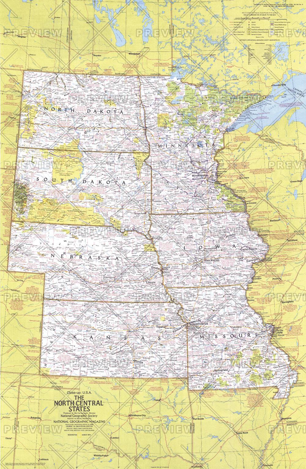
A richly detailed regional map capturing the vast landscapes and cultural depth of the American heartland. Published by National Geographic in 1974, this Close-up: U.S.A. edition explores the North Central United States—a region defined by open plains, agricultural strength, and deep-rooted history.
Covering states across the Midwest and Great Plains, this map offers more than geography. It’s a travel companion and historical snapshot, highlighting the people, places, and experiences that define the centre of the nation.
Why This Map Stands Out
A true heartland perspective
Focuses on the central states of the U.S., offering depth and clarity often lost in national maps.
Rich travel and cultural detail
Includes extensive information on parks, festivals, events, and historic sites.
Classic National Geographic cartography
Clean design, balanced colour, and precise labelling ensure both readability and visual appeal.
A snapshot of 1970s America
Captures infrastructure, regional connections, and cultural highlights of the era.
Part of the Close-up U.S.A. series
A collectible piece from one of National Geographic’s most respected regional map collections.
🗺️ What the Map Shows
- Coverage of the North Central United States, including the Great Plains and Midwest regions
- States such as North Dakota, South Dakota, Nebraska, Kansas, Minnesota, Iowa, and Missouri
- Major cities, transport routes, and regional infrastructure
- Locations of national and state parks, festivals, and key attractions
- Historic sites and notes that bring regional stories to life
- A geographic framework highlighting plains, river systems, and agricultural landscapes
📐 Size & Format
578 mm (W) × 886 mm (H)
Portrait orientation
A tall, elegant format ideal for:
- Home offices and studies
- Classrooms and history displays
- Libraries and research environments
- Americana or rural-themed interiors
✨ Premium Finishes
| Format | Description |
|---|---|
| 📜 Paper (160 gsm) | Heavyweight matte-coated paper—ideal for framing. Preserves crisp detail and vintage tones. |
| 🧼 Laminated (Encapsulated) | Sealed in 2 × 80-micron gloss laminate. Durable, wipe-clean, and suitable for frequent use. |
| 🪵 Laminated + Timber Hang Rails | Laminated map mounted with lacquered natural timber rails and hanging cord—ready to display. |
| 🖼️ Canvas (395 gsm HP Professional Matte) | Printed with archival pigment inks. Rich texture enhances the classic cartographic style. |
| 🪵 Canvas + Timber Hang Rails | Canvas paired with timber rails for a refined, gallery-style presentation. |
🔨 Please allow up to 10 working days for professionally mounted hang-railed finishes.
📊 Specifications
| Feature | Detail |
|---|---|
| Title | Close-up U.S.A. — North Central States |
| Publisher | National Geographic |
| Published | 1974 |
| Dimensions | 578 mm × 886 mm |
| Orientation | Portrait |
| Map Type | Regional / Historical |
| Series | Close-up: U.S.A. |
| Coverage | North Central United States (Midwest & Great Plains) |
| Materials | 160 gsm matte paper / 2 × 80-micron laminate / 395 gsm HP Professional Matte Canvas |
| Printing | Pigment-based, fade-resistant inks |
| Origin | Printed in Australia |
🎯 Ideal For
- Collectors of National Geographic and historical maps
- Enthusiasts of Midwestern and Great Plains geography
- Educators teaching U.S. regions and cultural landscapes
- Offices and interiors seeking a classic Americana aesthetic
- Gift buyers looking for a meaningful and region-specific map
🌾 The Landscape of America’s Heartland
This map captures a region defined by openness and scale:
- Vast plains stretching to the horizon
- River systems supporting agriculture and settlement
- Small towns and cities tied to industry and farming
- A strong connection between land, livelihood, and identity
It’s a portrait of a region where space, movement, and tradition shape everyday life.
🤝 Our Commitment
- Printed in Australia using archival-quality production
- Faithfully reproduced to preserve original colour and detail
- Premium materials selected for durability and longevity
- Each map is hand-checked before dispatch
- Carefully packaged for safe delivery
🚚 Delivery
- Paper, Laminated, Canvas (rolled): Dispatch within 1–2 business days
- Hang-Railed Maps: Made to order—allow up to 10 working days
- Packaging: Securely rolled in protective tubing
Explore the breadth and character of America’s heartland—
a map that captures both place and way of life.
👉 Order now and own a classic piece of National Geographic cartography.
Original: $57.20
-65%$57.20
$20.02Product Information
Product Information
Shipping & Returns
Shipping & Returns
Description
Historic Regional Map | America’s Heartland | Large Wall Format (578 × 886 mm) | Premium Finishes
A richly detailed regional map capturing the vast landscapes and cultural depth of the American heartland. Published by National Geographic in 1974, this Close-up: U.S.A. edition explores the North Central United States—a region defined by open plains, agricultural strength, and deep-rooted history.
Covering states across the Midwest and Great Plains, this map offers more than geography. It’s a travel companion and historical snapshot, highlighting the people, places, and experiences that define the centre of the nation.
Why This Map Stands Out
A true heartland perspective
Focuses on the central states of the U.S., offering depth and clarity often lost in national maps.
Rich travel and cultural detail
Includes extensive information on parks, festivals, events, and historic sites.
Classic National Geographic cartography
Clean design, balanced colour, and precise labelling ensure both readability and visual appeal.
A snapshot of 1970s America
Captures infrastructure, regional connections, and cultural highlights of the era.
Part of the Close-up U.S.A. series
A collectible piece from one of National Geographic’s most respected regional map collections.
🗺️ What the Map Shows
- Coverage of the North Central United States, including the Great Plains and Midwest regions
- States such as North Dakota, South Dakota, Nebraska, Kansas, Minnesota, Iowa, and Missouri
- Major cities, transport routes, and regional infrastructure
- Locations of national and state parks, festivals, and key attractions
- Historic sites and notes that bring regional stories to life
- A geographic framework highlighting plains, river systems, and agricultural landscapes
📐 Size & Format
578 mm (W) × 886 mm (H)
Portrait orientation
A tall, elegant format ideal for:
- Home offices and studies
- Classrooms and history displays
- Libraries and research environments
- Americana or rural-themed interiors
✨ Premium Finishes
| Format | Description |
|---|---|
| 📜 Paper (160 gsm) | Heavyweight matte-coated paper—ideal for framing. Preserves crisp detail and vintage tones. |
| 🧼 Laminated (Encapsulated) | Sealed in 2 × 80-micron gloss laminate. Durable, wipe-clean, and suitable for frequent use. |
| 🪵 Laminated + Timber Hang Rails | Laminated map mounted with lacquered natural timber rails and hanging cord—ready to display. |
| 🖼️ Canvas (395 gsm HP Professional Matte) | Printed with archival pigment inks. Rich texture enhances the classic cartographic style. |
| 🪵 Canvas + Timber Hang Rails | Canvas paired with timber rails for a refined, gallery-style presentation. |
🔨 Please allow up to 10 working days for professionally mounted hang-railed finishes.
📊 Specifications
| Feature | Detail |
|---|---|
| Title | Close-up U.S.A. — North Central States |
| Publisher | National Geographic |
| Published | 1974 |
| Dimensions | 578 mm × 886 mm |
| Orientation | Portrait |
| Map Type | Regional / Historical |
| Series | Close-up: U.S.A. |
| Coverage | North Central United States (Midwest & Great Plains) |
| Materials | 160 gsm matte paper / 2 × 80-micron laminate / 395 gsm HP Professional Matte Canvas |
| Printing | Pigment-based, fade-resistant inks |
| Origin | Printed in Australia |
🎯 Ideal For
- Collectors of National Geographic and historical maps
- Enthusiasts of Midwestern and Great Plains geography
- Educators teaching U.S. regions and cultural landscapes
- Offices and interiors seeking a classic Americana aesthetic
- Gift buyers looking for a meaningful and region-specific map
🌾 The Landscape of America’s Heartland
This map captures a region defined by openness and scale:
- Vast plains stretching to the horizon
- River systems supporting agriculture and settlement
- Small towns and cities tied to industry and farming
- A strong connection between land, livelihood, and identity
It’s a portrait of a region where space, movement, and tradition shape everyday life.
🤝 Our Commitment
- Printed in Australia using archival-quality production
- Faithfully reproduced to preserve original colour and detail
- Premium materials selected for durability and longevity
- Each map is hand-checked before dispatch
- Carefully packaged for safe delivery
🚚 Delivery
- Paper, Laminated, Canvas (rolled): Dispatch within 1–2 business days
- Hang-Railed Maps: Made to order—allow up to 10 working days
- Packaging: Securely rolled in protective tubing
Explore the breadth and character of America’s heartland—
a map that captures both place and way of life.
👉 Order now and own a classic piece of National Geographic cartography.


