Close-up USA, Northeast - Published 1978 by National Geographic
Historic Regional Map | Cities, Mountains & Countryside | Large Wall Format (884 × 574 mm) | Premium Finishes
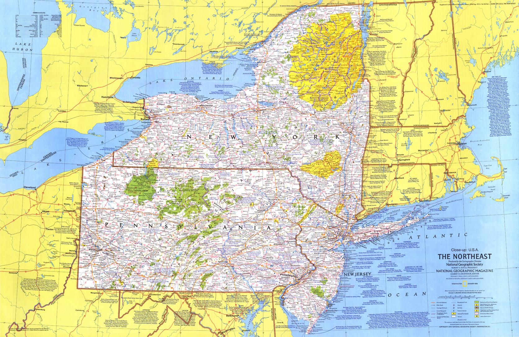
A richly detailed regional map capturing the diversity and energy of the northeastern United States. Published by National Geographic in 1978, this Close-up: U.S.A. edition focuses on New York, New Jersey, and Pennsylvania—a region where global cities, mountain landscapes, and rural traditions meet.
From the urban intensity of New York City and Philadelphia to the forested ranges of the Adirondacks and Catskills, this map offers a compelling snapshot of a region defined by contrast, movement, and cultural depth.
Why This Map Stands Out
A region of contrasts in one view
Combines major metropolitan centres with wilderness, farmland, and historic regions.
Classic National Geographic cartography
Clean typography, balanced colour, and precise detail ensure clarity and visual appeal.
A snapshot of 1978 America
Captures transport networks, cities, and regional connections of the late 20th century.
Part of the Close-up U.S.A. series
A collectible piece from one of National Geographic’s most respected regional map collections.
Strong visual and storytelling appeal
Works equally well as a reference map or a decorative wall feature.
🗺️ What the Map Shows
- Detailed coverage of New York, New Jersey, and Pennsylvania
- Major urban centres including New York City and Philadelphia
- Mountain regions such as the Adirondacks and Catskills
- Rural landscapes including Pennsylvania Dutch country
- Transport routes, rivers, and regional infrastructure
- A geographic framework linking cities, forests, farmland, and recreation areas
📐 Size & Format
884 mm (W) × 574 mm (H)
Landscape orientation
A versatile wall size that offers strong readability—ideal for:
- Home offices and studies
- Classrooms and geography displays
- Libraries and research environments
- Interiors with a travel or Americana theme
✨ Premium Finishes
| Format | Description |
|---|---|
| 📜 Paper (160 gsm) | Heavyweight matte-coated paper—ideal for framing. Preserves crisp detail and vintage tones. |
| 🧼 Laminated (Encapsulated) | Sealed in 2 × 80-micron gloss laminate. Durable, wipe-clean, and suitable for frequent use. |
| 🪵 Laminated + Timber Hang Rails | Laminated map mounted with lacquered natural timber rails and hanging cord—ready to display. |
| 🖼️ Canvas (395 gsm HP Professional Matte) | Printed with archival pigment inks. Rich texture enhances the classic cartographic style. |
| 🪵 Canvas + Timber Hang Rails | Canvas paired with timber rails for a refined, gallery-style presentation. |
🔨 Please allow up to 10 working days for professionally mounted hang-railed finishes.
📊 Specifications
| Feature | Detail |
|---|---|
| Title | Close-up U.S.A. — Northeast (New York, New Jersey, Pennsylvania) |
| Publisher | National Geographic |
| Published | 1978 |
| Scale | 1:1,215,000 |
| Dimensions | 884 mm × 574 mm |
| Orientation | Landscape |
| Map Type | Regional / Historical |
| Series | Close-up: U.S.A. |
| Coverage | New York, New Jersey, Pennsylvania |
| Materials | 160 gsm matte paper / 2 × 80-micron laminate / 395 gsm HP Professional Matte Canvas |
| Printing | Pigment-based, fade-resistant inks |
| Origin | Printed in Australia |
🎯 Ideal For
- Collectors of National Geographic and historical maps
- Enthusiasts of U.S. Northeast geography and culture
- Educators teaching regional geography and urban development
- Offices and interiors seeking a classic Americana aesthetic
- Gift buyers looking for a location-specific and meaningful map
🌆 Cities, Wilderness & Heritage
This region captures a unique American balance:
- Global cities driving culture, finance, and movement
- Mountain landscapes offering recreation and escape
- Rural traditions preserved in farming communities
- A dense network of connections shaping everyday life
It’s a map of a region where urban energy meets natural quiet—and history sits just beneath the surface.
🤝 Our Commitment
- Printed in Australia using archival-quality production
- Faithfully reproduced to preserve original colour and detail
- Premium materials selected for durability and longevity
- Each map is hand-checked before dispatch
- Carefully packaged for safe delivery
🚚 Delivery
- Paper, Laminated, Canvas (rolled): Dispatch within 1–2 business days
- Hang-Railed Maps: Made to order—allow up to 10 working days
- Packaging: Securely rolled in protective tubing
Explore one of America’s most dynamic regions—
a map that captures both energy and landscape.
👉 Order now and own a classic piece of National Geographic cartography.
Original: $57.20
-65%$57.20
$20.02Product Information
Product Information
Shipping & Returns
Shipping & Returns
Description
Historic Regional Map | Cities, Mountains & Countryside | Large Wall Format (884 × 574 mm) | Premium Finishes
A richly detailed regional map capturing the diversity and energy of the northeastern United States. Published by National Geographic in 1978, this Close-up: U.S.A. edition focuses on New York, New Jersey, and Pennsylvania—a region where global cities, mountain landscapes, and rural traditions meet.
From the urban intensity of New York City and Philadelphia to the forested ranges of the Adirondacks and Catskills, this map offers a compelling snapshot of a region defined by contrast, movement, and cultural depth.
Why This Map Stands Out
A region of contrasts in one view
Combines major metropolitan centres with wilderness, farmland, and historic regions.
Classic National Geographic cartography
Clean typography, balanced colour, and precise detail ensure clarity and visual appeal.
A snapshot of 1978 America
Captures transport networks, cities, and regional connections of the late 20th century.
Part of the Close-up U.S.A. series
A collectible piece from one of National Geographic’s most respected regional map collections.
Strong visual and storytelling appeal
Works equally well as a reference map or a decorative wall feature.
🗺️ What the Map Shows
- Detailed coverage of New York, New Jersey, and Pennsylvania
- Major urban centres including New York City and Philadelphia
- Mountain regions such as the Adirondacks and Catskills
- Rural landscapes including Pennsylvania Dutch country
- Transport routes, rivers, and regional infrastructure
- A geographic framework linking cities, forests, farmland, and recreation areas
📐 Size & Format
884 mm (W) × 574 mm (H)
Landscape orientation
A versatile wall size that offers strong readability—ideal for:
- Home offices and studies
- Classrooms and geography displays
- Libraries and research environments
- Interiors with a travel or Americana theme
✨ Premium Finishes
| Format | Description |
|---|---|
| 📜 Paper (160 gsm) | Heavyweight matte-coated paper—ideal for framing. Preserves crisp detail and vintage tones. |
| 🧼 Laminated (Encapsulated) | Sealed in 2 × 80-micron gloss laminate. Durable, wipe-clean, and suitable for frequent use. |
| 🪵 Laminated + Timber Hang Rails | Laminated map mounted with lacquered natural timber rails and hanging cord—ready to display. |
| 🖼️ Canvas (395 gsm HP Professional Matte) | Printed with archival pigment inks. Rich texture enhances the classic cartographic style. |
| 🪵 Canvas + Timber Hang Rails | Canvas paired with timber rails for a refined, gallery-style presentation. |
🔨 Please allow up to 10 working days for professionally mounted hang-railed finishes.
📊 Specifications
| Feature | Detail |
|---|---|
| Title | Close-up U.S.A. — Northeast (New York, New Jersey, Pennsylvania) |
| Publisher | National Geographic |
| Published | 1978 |
| Scale | 1:1,215,000 |
| Dimensions | 884 mm × 574 mm |
| Orientation | Landscape |
| Map Type | Regional / Historical |
| Series | Close-up: U.S.A. |
| Coverage | New York, New Jersey, Pennsylvania |
| Materials | 160 gsm matte paper / 2 × 80-micron laminate / 395 gsm HP Professional Matte Canvas |
| Printing | Pigment-based, fade-resistant inks |
| Origin | Printed in Australia |
🎯 Ideal For
- Collectors of National Geographic and historical maps
- Enthusiasts of U.S. Northeast geography and culture
- Educators teaching regional geography and urban development
- Offices and interiors seeking a classic Americana aesthetic
- Gift buyers looking for a location-specific and meaningful map
🌆 Cities, Wilderness & Heritage
This region captures a unique American balance:
- Global cities driving culture, finance, and movement
- Mountain landscapes offering recreation and escape
- Rural traditions preserved in farming communities
- A dense network of connections shaping everyday life
It’s a map of a region where urban energy meets natural quiet—and history sits just beneath the surface.
🤝 Our Commitment
- Printed in Australia using archival-quality production
- Faithfully reproduced to preserve original colour and detail
- Premium materials selected for durability and longevity
- Each map is hand-checked before dispatch
- Carefully packaged for safe delivery
🚚 Delivery
- Paper, Laminated, Canvas (rolled): Dispatch within 1–2 business days
- Hang-Railed Maps: Made to order—allow up to 10 working days
- Packaging: Securely rolled in protective tubing
Explore one of America’s most dynamic regions—
a map that captures both energy and landscape.
👉 Order now and own a classic piece of National Geographic cartography.


