Close-up USA, Northwest - Published 1973 by National Geographic
Historic Regional Map | Mountains, Forests & National Parks | Large Wall Format (888 × 573 mm) | Premium Finishes
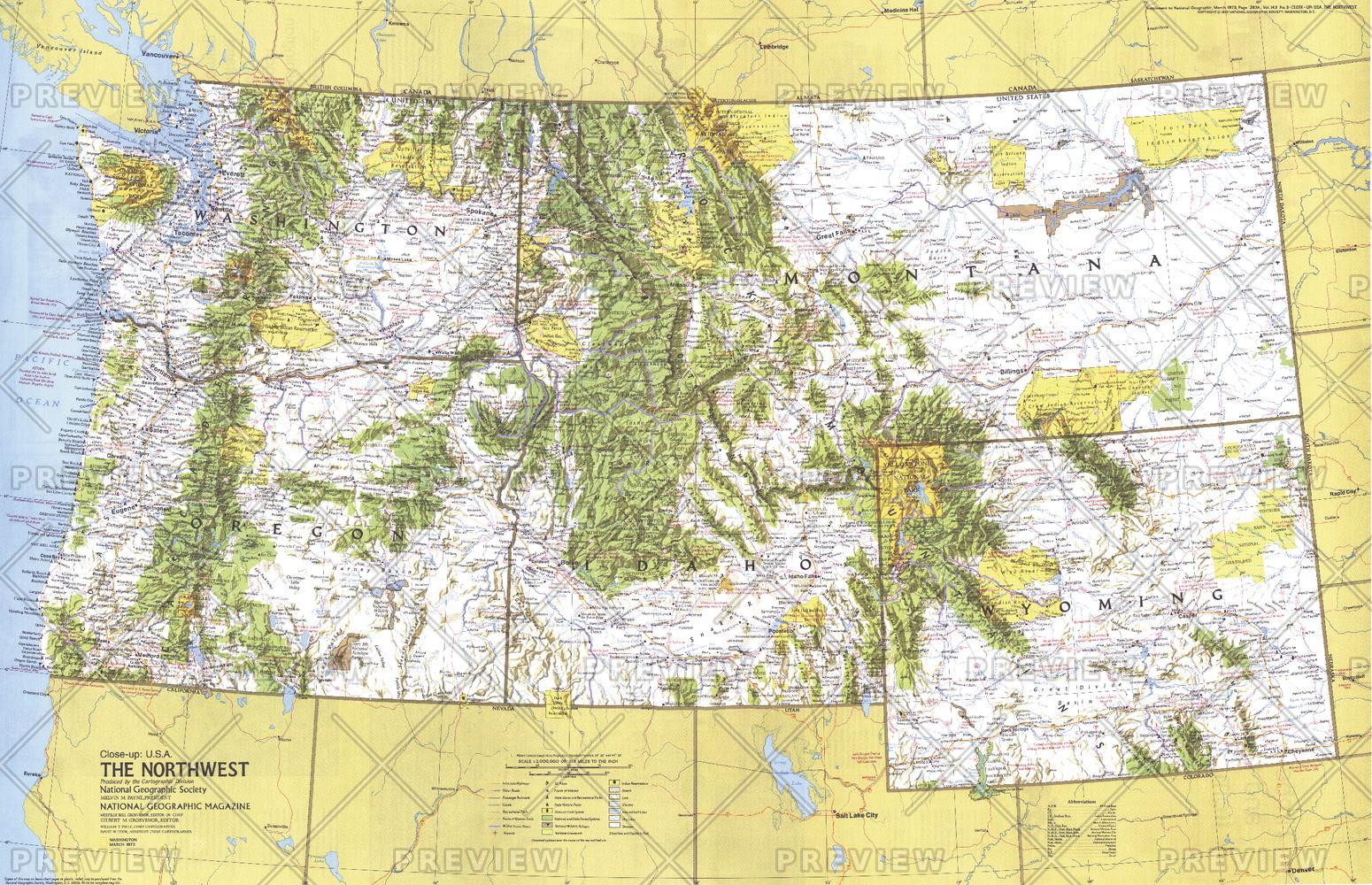
A richly detailed regional map capturing the scale and natural grandeur of the northwestern United States. Published by National Geographic in 1973, this Close-up: U.S.A. edition explores a region defined by mountain ranges, dense forests, and some of America’s most iconic national parks.
From the misty Pacific coastline to inland peaks and open ranges, this map offers a compelling snapshot of a landscape shaped by wilderness, water, and wide-open space—as it appeared in the early 1970s.
Why This Map Stands Out
A region defined by nature
Focuses on the Pacific Northwest and Northern Rockies—areas rich in national parks, forests, and scenic landscapes.
Classic National Geographic cartography
Clean typography, balanced colour, and precise detail ensure clarity and visual appeal.
A snapshot of 1970s America
Captures infrastructure, travel routes, and regional connections of the era.
Part of the Close-up U.S.A. series
A collectible piece from one of National Geographic’s most respected regional map collections.
Strong visual and storytelling appeal
Works equally well as a geographic reference or a striking wall display.
🗺️ What the Map Shows
- Coverage of the Northwest United States, including Washington, Oregon, Idaho, Montana, and Wyoming
- Major cities, transport routes, and regional connections
- Extensive national parks and forest systems, highlighting key recreational areas
- Mountain ranges including the Cascades and Rocky Mountains
- Rivers, valleys, and coastal features shaping the region
- Historical notes and travel insights that bring the landscape to life
📐 Size & Format
888 mm (W) × 573 mm (H)
Landscape orientation
A versatile wall size offering strong readability—ideal for:
- Home offices and studies
- Classrooms and geography displays
- Libraries and research environments
- Interiors inspired by wilderness and outdoor travel
✨ Premium Finishes
| Format | Description |
|---|---|
| 📜 Paper (160 gsm) | Heavyweight matte-coated paper—ideal for framing. Preserves crisp detail and vintage tones. |
| 🧼 Laminated (Encapsulated) | Sealed in 2 × 80-micron gloss laminate. Durable, wipe-clean, and suitable for frequent use. |
| 🪵 Laminated + Timber Hang Rails | Laminated map mounted with lacquered natural timber rails and hanging cord—ready to display. |
| 🖼️ Canvas (395 gsm HP Professional Matte) | Printed with archival pigment inks. Rich texture enhances the classic cartographic style. |
| 🪵 Canvas + Timber Hang Rails | Canvas paired with timber rails for a refined, gallery-style presentation. |
🔨 Please allow up to 10 working days for professionally mounted hang-railed finishes.
📊 Specifications
| Feature | Detail |
|---|---|
| Title | Close-up U.S.A. — Northwest (Washington, Oregon, Idaho, Montana, Wyoming) |
| Publisher | National Geographic |
| Published | 1973 |
| Dimensions | 888 mm × 573 mm |
| Orientation | Landscape |
| Map Type | Regional / Historical |
| Series | Close-up: U.S.A. |
| Coverage | Northwest United States |
| Materials | 160 gsm matte paper / 2 × 80-micron laminate / 395 gsm HP Professional Matte Canvas |
| Printing | Pigment-based, fade-resistant inks |
| Origin | Printed in Australia |
🎯 Ideal For
- Collectors of National Geographic and historical maps
- Enthusiasts of Pacific Northwest and Rocky Mountain landscapes
- Educators teaching U.S. regional geography and natural environments
- Outdoor lovers and travellers inspired by national parks and wilderness
- Gift buyers seeking a meaningful and visually striking map
🌲 A Landscape of Wilderness and Scale
This region is defined by its natural power:
- Mountain ranges rising sharply from coast to interior
- Dense forests and protected wilderness areas
- Rivers and valleys shaping travel and settlement
- A strong connection between land, climate, and lifestyle
It’s a map of a region where nature dominates—and human activity adapts to it.
🤝 Our Commitment
- Printed in Australia using archival-quality production
- Faithfully reproduced to preserve original colour and detail
- Premium materials selected for durability and longevity
- Each map is hand-checked before dispatch
- Carefully packaged for safe delivery
🚚 Delivery
- Paper, Laminated, Canvas (rolled): Dispatch within 1–2 business days
- Hang-Railed Maps: Made to order—allow up to 10 working days
- Packaging: Securely rolled in protective tubing
Explore the wild beauty of the American Northwest—
a map that captures both landscape and legacy.
👉 Order now and own a classic piece of National Geographic cartography.
Original: $57.20
-65%$57.20
$20.02Product Information
Product Information
Shipping & Returns
Shipping & Returns
Description
Historic Regional Map | Mountains, Forests & National Parks | Large Wall Format (888 × 573 mm) | Premium Finishes
A richly detailed regional map capturing the scale and natural grandeur of the northwestern United States. Published by National Geographic in 1973, this Close-up: U.S.A. edition explores a region defined by mountain ranges, dense forests, and some of America’s most iconic national parks.
From the misty Pacific coastline to inland peaks and open ranges, this map offers a compelling snapshot of a landscape shaped by wilderness, water, and wide-open space—as it appeared in the early 1970s.
Why This Map Stands Out
A region defined by nature
Focuses on the Pacific Northwest and Northern Rockies—areas rich in national parks, forests, and scenic landscapes.
Classic National Geographic cartography
Clean typography, balanced colour, and precise detail ensure clarity and visual appeal.
A snapshot of 1970s America
Captures infrastructure, travel routes, and regional connections of the era.
Part of the Close-up U.S.A. series
A collectible piece from one of National Geographic’s most respected regional map collections.
Strong visual and storytelling appeal
Works equally well as a geographic reference or a striking wall display.
🗺️ What the Map Shows
- Coverage of the Northwest United States, including Washington, Oregon, Idaho, Montana, and Wyoming
- Major cities, transport routes, and regional connections
- Extensive national parks and forest systems, highlighting key recreational areas
- Mountain ranges including the Cascades and Rocky Mountains
- Rivers, valleys, and coastal features shaping the region
- Historical notes and travel insights that bring the landscape to life
📐 Size & Format
888 mm (W) × 573 mm (H)
Landscape orientation
A versatile wall size offering strong readability—ideal for:
- Home offices and studies
- Classrooms and geography displays
- Libraries and research environments
- Interiors inspired by wilderness and outdoor travel
✨ Premium Finishes
| Format | Description |
|---|---|
| 📜 Paper (160 gsm) | Heavyweight matte-coated paper—ideal for framing. Preserves crisp detail and vintage tones. |
| 🧼 Laminated (Encapsulated) | Sealed in 2 × 80-micron gloss laminate. Durable, wipe-clean, and suitable for frequent use. |
| 🪵 Laminated + Timber Hang Rails | Laminated map mounted with lacquered natural timber rails and hanging cord—ready to display. |
| 🖼️ Canvas (395 gsm HP Professional Matte) | Printed with archival pigment inks. Rich texture enhances the classic cartographic style. |
| 🪵 Canvas + Timber Hang Rails | Canvas paired with timber rails for a refined, gallery-style presentation. |
🔨 Please allow up to 10 working days for professionally mounted hang-railed finishes.
📊 Specifications
| Feature | Detail |
|---|---|
| Title | Close-up U.S.A. — Northwest (Washington, Oregon, Idaho, Montana, Wyoming) |
| Publisher | National Geographic |
| Published | 1973 |
| Dimensions | 888 mm × 573 mm |
| Orientation | Landscape |
| Map Type | Regional / Historical |
| Series | Close-up: U.S.A. |
| Coverage | Northwest United States |
| Materials | 160 gsm matte paper / 2 × 80-micron laminate / 395 gsm HP Professional Matte Canvas |
| Printing | Pigment-based, fade-resistant inks |
| Origin | Printed in Australia |
🎯 Ideal For
- Collectors of National Geographic and historical maps
- Enthusiasts of Pacific Northwest and Rocky Mountain landscapes
- Educators teaching U.S. regional geography and natural environments
- Outdoor lovers and travellers inspired by national parks and wilderness
- Gift buyers seeking a meaningful and visually striking map
🌲 A Landscape of Wilderness and Scale
This region is defined by its natural power:
- Mountain ranges rising sharply from coast to interior
- Dense forests and protected wilderness areas
- Rivers and valleys shaping travel and settlement
- A strong connection between land, climate, and lifestyle
It’s a map of a region where nature dominates—and human activity adapts to it.
🤝 Our Commitment
- Printed in Australia using archival-quality production
- Faithfully reproduced to preserve original colour and detail
- Premium materials selected for durability and longevity
- Each map is hand-checked before dispatch
- Carefully packaged for safe delivery
🚚 Delivery
- Paper, Laminated, Canvas (rolled): Dispatch within 1–2 business days
- Hang-Railed Maps: Made to order—allow up to 10 working days
- Packaging: Securely rolled in protective tubing
Explore the wild beauty of the American Northwest—
a map that captures both landscape and legacy.
👉 Order now and own a classic piece of National Geographic cartography.


