Close-up USA, South Central States - Published 1974 by National Geographic
Historic Regional Map | Plains, Bayous & the Southern Frontier | Large Wall Format (888 × 578 mm) | Premium Finishes
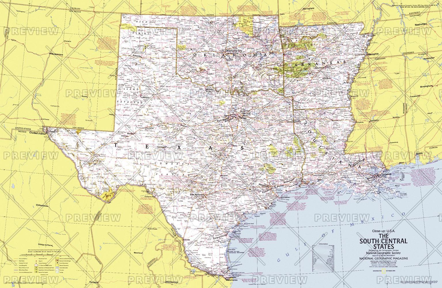
A richly detailed regional map capturing the diversity and cultural depth of the American South Central states. Published by National Geographic in 1974, this Close-up: U.S.A. edition explores a region where open plains, river deltas, and vibrant traditions come together.
Covering Arkansas, Oklahoma, Louisiana, and Texas, this map reveals a landscape shaped by cattle country, river systems, and coastal wetlands—alongside a rich blend of cultures and histories. It’s both a geographic reference and a cultural snapshot of the region as it appeared in the mid-1970s.
Why This Map Stands Out
A region of striking diversity
From prairie lands and ranching country to bayous and river deltas, the South Central states offer remarkable contrast.
Classic National Geographic cartography
Clean typography, balanced colour, and precise detail ensure clarity and enduring visual appeal.
A snapshot of 1970s America
Captures infrastructure, cities, and regional connections of the era.
Part of the Close-up U.S.A. series
A collectible piece from one of National Geographic’s most respected regional map collections.
Rich travel and historical context
Includes extensive notes on attractions, cultural sites, and regional history.
🗺️ What the Map Shows
- Detailed coverage of Arkansas, Oklahoma, Louisiana, and Texas
- Major cities, transport routes, and regional infrastructure
- Landscapes ranging from Great Plains and ranchlands to Mississippi Delta and Gulf Coast wetlands
- Cultural highlights including Indigenous centres, Cajun regions, and historic towns
- Locations tied to festivals, traditions, and regional heritage
- A geographic framework linking plains, rivers, coastlines, and cultural regions
📐 Size & Format
888 mm (W) × 578 mm (H)
Landscape orientation
A versatile wall size offering strong readability—ideal for:
- Home offices and studies
- Classrooms and history displays
- Libraries and research environments
- Interiors inspired by Americana and regional heritage
✨ Premium Finishes
| Format | Description |
|---|---|
| 📜 Paper (160 gsm) | Heavyweight matte-coated paper—ideal for framing. Preserves crisp detail and vintage tones. |
| 🧼 Laminated (Encapsulated) | Sealed in 2 × 80-micron gloss laminate. Durable, wipe-clean, and suitable for frequent use. |
| 🪵 Laminated + Timber Hang Rails | Laminated map mounted with lacquered natural timber rails and hanging cord—ready to display. |
| 🖼️ Canvas (395 gsm HP Professional Matte) | Printed with archival pigment inks. Rich texture enhances the classic cartographic style. |
| 🪵 Canvas + Timber Hang Rails | Canvas paired with timber rails for a refined, gallery-style presentation. |
🔨 Please allow up to 10 working days for professionally mounted hang-railed finishes.
📊 Specifications
| Feature | Detail |
|---|---|
| Title | Close-up U.S.A. — South Central States |
| Publisher | National Geographic |
| Published | 1974 |
| Dimensions | 888 mm × 578 mm |
| Orientation | Landscape |
| Map Type | Regional / Historical |
| Series | Close-up: U.S.A. |
| Coverage | Arkansas, Oklahoma, Louisiana, Texas |
| Materials | 160 gsm matte paper / 2 × 80-micron laminate / 395 gsm HP Professional Matte Canvas |
| Printing | Pigment-based, fade-resistant inks |
| Origin | Printed in Australia |
🎯 Ideal For
- Collectors of National Geographic and historical maps
- Enthusiasts of Southern U.S. geography and culture
- Educators teaching regional landscapes and cultural diversity
- Offices and interiors seeking a classic Americana aesthetic
- Gift buyers looking for a meaningful and region-specific map
🌾 Land, Culture & Frontier Spirit
The South Central region tells a layered story:
- Vast plains shaped by cattle and agriculture
- River systems defining trade, settlement, and culture
- Coastal bayous rich in biodiversity and tradition
- A blend of Indigenous heritage, frontier history, and Southern identity
This map reveals a region where landscape and culture are inseparable.
🤝 Our Commitment
- Printed in Australia using archival-quality production
- Faithfully reproduced to preserve original colour and detail
- Premium materials selected for durability and longevity
- Each map is hand-checked before dispatch
- Carefully packaged for safe delivery
🚚 Delivery
- Paper, Laminated, Canvas (rolled): Dispatch within 1–2 business days
- Hang-Railed Maps: Made to order—allow up to 10 working days
- Packaging: Securely rolled in protective tubing
Explore the depth and diversity of America’s southern heartland—
a map that captures both landscape and culture.
👉 Order now and own a classic piece of National Geographic cartography.
Original: $57.20
-65%$57.20
$20.02Product Information
Product Information
Shipping & Returns
Shipping & Returns
Description
Historic Regional Map | Plains, Bayous & the Southern Frontier | Large Wall Format (888 × 578 mm) | Premium Finishes
A richly detailed regional map capturing the diversity and cultural depth of the American South Central states. Published by National Geographic in 1974, this Close-up: U.S.A. edition explores a region where open plains, river deltas, and vibrant traditions come together.
Covering Arkansas, Oklahoma, Louisiana, and Texas, this map reveals a landscape shaped by cattle country, river systems, and coastal wetlands—alongside a rich blend of cultures and histories. It’s both a geographic reference and a cultural snapshot of the region as it appeared in the mid-1970s.
Why This Map Stands Out
A region of striking diversity
From prairie lands and ranching country to bayous and river deltas, the South Central states offer remarkable contrast.
Classic National Geographic cartography
Clean typography, balanced colour, and precise detail ensure clarity and enduring visual appeal.
A snapshot of 1970s America
Captures infrastructure, cities, and regional connections of the era.
Part of the Close-up U.S.A. series
A collectible piece from one of National Geographic’s most respected regional map collections.
Rich travel and historical context
Includes extensive notes on attractions, cultural sites, and regional history.
🗺️ What the Map Shows
- Detailed coverage of Arkansas, Oklahoma, Louisiana, and Texas
- Major cities, transport routes, and regional infrastructure
- Landscapes ranging from Great Plains and ranchlands to Mississippi Delta and Gulf Coast wetlands
- Cultural highlights including Indigenous centres, Cajun regions, and historic towns
- Locations tied to festivals, traditions, and regional heritage
- A geographic framework linking plains, rivers, coastlines, and cultural regions
📐 Size & Format
888 mm (W) × 578 mm (H)
Landscape orientation
A versatile wall size offering strong readability—ideal for:
- Home offices and studies
- Classrooms and history displays
- Libraries and research environments
- Interiors inspired by Americana and regional heritage
✨ Premium Finishes
| Format | Description |
|---|---|
| 📜 Paper (160 gsm) | Heavyweight matte-coated paper—ideal for framing. Preserves crisp detail and vintage tones. |
| 🧼 Laminated (Encapsulated) | Sealed in 2 × 80-micron gloss laminate. Durable, wipe-clean, and suitable for frequent use. |
| 🪵 Laminated + Timber Hang Rails | Laminated map mounted with lacquered natural timber rails and hanging cord—ready to display. |
| 🖼️ Canvas (395 gsm HP Professional Matte) | Printed with archival pigment inks. Rich texture enhances the classic cartographic style. |
| 🪵 Canvas + Timber Hang Rails | Canvas paired with timber rails for a refined, gallery-style presentation. |
🔨 Please allow up to 10 working days for professionally mounted hang-railed finishes.
📊 Specifications
| Feature | Detail |
|---|---|
| Title | Close-up U.S.A. — South Central States |
| Publisher | National Geographic |
| Published | 1974 |
| Dimensions | 888 mm × 578 mm |
| Orientation | Landscape |
| Map Type | Regional / Historical |
| Series | Close-up: U.S.A. |
| Coverage | Arkansas, Oklahoma, Louisiana, Texas |
| Materials | 160 gsm matte paper / 2 × 80-micron laminate / 395 gsm HP Professional Matte Canvas |
| Printing | Pigment-based, fade-resistant inks |
| Origin | Printed in Australia |
🎯 Ideal For
- Collectors of National Geographic and historical maps
- Enthusiasts of Southern U.S. geography and culture
- Educators teaching regional landscapes and cultural diversity
- Offices and interiors seeking a classic Americana aesthetic
- Gift buyers looking for a meaningful and region-specific map
🌾 Land, Culture & Frontier Spirit
The South Central region tells a layered story:
- Vast plains shaped by cattle and agriculture
- River systems defining trade, settlement, and culture
- Coastal bayous rich in biodiversity and tradition
- A blend of Indigenous heritage, frontier history, and Southern identity
This map reveals a region where landscape and culture are inseparable.
🤝 Our Commitment
- Printed in Australia using archival-quality production
- Faithfully reproduced to preserve original colour and detail
- Premium materials selected for durability and longevity
- Each map is hand-checked before dispatch
- Carefully packaged for safe delivery
🚚 Delivery
- Paper, Laminated, Canvas (rolled): Dispatch within 1–2 business days
- Hang-Railed Maps: Made to order—allow up to 10 working days
- Packaging: Securely rolled in protective tubing
Explore the depth and diversity of America’s southern heartland—
a map that captures both landscape and culture.
👉 Order now and own a classic piece of National Geographic cartography.


