Close-up USA, the Southeast - Published 1975 by National Geographic
Historic Regional Map | Coastlines, Rivers & Southern Heritage | Large Wall Format (888 × 577 mm) | Premium Finishes
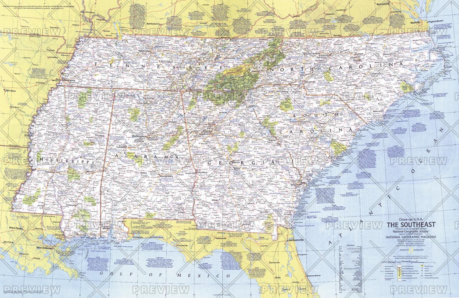
A richly detailed regional map capturing the character, history, and landscapes of the southeastern United States. Published by National Geographic in 1975, this Close-up: U.S.A. edition explores a region stretching from the Atlantic seaboard to the Mississippi River—a landscape shaped by waterways, agriculture, and deep cultural roots.
From coastal plains and barrier islands to inland mountains and river valleys, this map offers a compelling snapshot of the Southeast as it appeared in the mid-1970s—revealing a region defined by history, movement, and identity.
Why This Map Stands Out
A region rich in heritage
Highlights the Southeast’s deep historical significance—from early settlements to cultural traditions that continue today.
Classic National Geographic cartography
Clean typography, balanced colour, and precise detail ensure clarity and visual appeal.
A snapshot of 1970s America
Captures infrastructure, cities, and regional connections of the era.
Part of the Close-up U.S.A. series
A collectible piece from one of National Geographic’s most respected regional map collections.
Balanced visual and educational appeal
Works equally well as a reference map or a striking wall display.
🗺️ What the Map Shows
- Coverage of the Southeastern United States, including Tennessee, North Carolina, South Carolina, Georgia, Alabama, and Mississippi
- Major cities, transport routes, and regional infrastructure
- Coastal landscapes along the Atlantic Ocean and inland river systems including the Mississippi River
- Mountain regions such as the Appalachians alongside plains and agricultural areas
- Locations tied to historical sites, cultural regions, and regional traditions
- A geographic framework linking coastlines, rivers, forests, and inland communities
📐 Size & Format
888 mm (W) × 577 mm (H)
Landscape orientation
A versatile wall size offering strong readability—ideal for:
- Home offices and studies
- Classrooms and history displays
- Libraries and research environments
- Interiors inspired by Americana and Southern heritage
✨ Premium Finishes
| Format | Description |
|---|---|
| 📜 Paper (160 gsm) | Heavyweight matte-coated paper—ideal for framing. Preserves crisp detail and vintage tones. |
| 🧼 Laminated (Encapsulated) | Sealed in 2 × 80-micron gloss laminate. Durable, wipe-clean, and suitable for frequent use. |
| 🪵 Laminated + Timber Hang Rails | Laminated map mounted with lacquered natural timber rails and hanging cord—ready to display. |
| 🖼️ Canvas (395 gsm HP Professional Matte) | Printed with archival pigment inks. Rich texture enhances the classic cartographic style. |
| 🪵 Canvas + Timber Hang Rails | Canvas paired with timber rails for a refined, gallery-style presentation. |
🔨 Please allow up to 10 working days for professionally mounted hang-railed finishes.
📊 Specifications
| Feature | Detail |
|---|---|
| Title | Close-up U.S.A. — Southeast |
| Publisher | National Geographic |
| Published | 1975 |
| Dimensions | 888 mm × 577 mm |
| Orientation | Landscape |
| Map Type | Regional / Historical |
| Series | Close-up: U.S.A. |
| Coverage | Southeastern United States |
| Materials | 160 gsm matte paper / 2 × 80-micron laminate / 395 gsm HP Professional Matte Canvas |
| Printing | Pigment-based, fade-resistant inks |
| Origin | Printed in Australia |
🎯 Ideal For
- Collectors of National Geographic and historical maps
- Enthusiasts of Southern U.S. geography and culture
- Educators teaching regional landscapes and history
- Offices and interiors seeking a classic Americana aesthetic
- Gift buyers looking for a meaningful and region-specific map
🌿 A Region Shaped by Land and Legacy
The Southeast tells a layered story:
- Coastlines and rivers guiding settlement and trade
- Agricultural landscapes shaping communities and economies
- Mountain regions providing contrast and natural beauty
- Cultural traditions deeply rooted in place and history
This map reveals a region where geography and heritage are inseparable.
🤝 Our Commitment
- Printed in Australia using archival-quality production
- Faithfully reproduced to preserve original colour and detail
- Premium materials selected for durability and longevity
- Each map is hand-checked before dispatch
- Carefully packaged for safe delivery
🚚 Delivery
- Paper, Laminated, Canvas (rolled): Dispatch within 1–2 business days
- Hang-Railed Maps: Made to order—allow up to 10 working days
- Packaging: Securely rolled in protective tubing
Explore the richness and depth of the American Southeast—
a map that captures both landscape and legacy.
👉 Order now and own a classic piece of National Geographic cartography.
Original: $57.20
-65%$57.20
$20.02Product Information
Product Information
Shipping & Returns
Shipping & Returns
Description
Historic Regional Map | Coastlines, Rivers & Southern Heritage | Large Wall Format (888 × 577 mm) | Premium Finishes
A richly detailed regional map capturing the character, history, and landscapes of the southeastern United States. Published by National Geographic in 1975, this Close-up: U.S.A. edition explores a region stretching from the Atlantic seaboard to the Mississippi River—a landscape shaped by waterways, agriculture, and deep cultural roots.
From coastal plains and barrier islands to inland mountains and river valleys, this map offers a compelling snapshot of the Southeast as it appeared in the mid-1970s—revealing a region defined by history, movement, and identity.
Why This Map Stands Out
A region rich in heritage
Highlights the Southeast’s deep historical significance—from early settlements to cultural traditions that continue today.
Classic National Geographic cartography
Clean typography, balanced colour, and precise detail ensure clarity and visual appeal.
A snapshot of 1970s America
Captures infrastructure, cities, and regional connections of the era.
Part of the Close-up U.S.A. series
A collectible piece from one of National Geographic’s most respected regional map collections.
Balanced visual and educational appeal
Works equally well as a reference map or a striking wall display.
🗺️ What the Map Shows
- Coverage of the Southeastern United States, including Tennessee, North Carolina, South Carolina, Georgia, Alabama, and Mississippi
- Major cities, transport routes, and regional infrastructure
- Coastal landscapes along the Atlantic Ocean and inland river systems including the Mississippi River
- Mountain regions such as the Appalachians alongside plains and agricultural areas
- Locations tied to historical sites, cultural regions, and regional traditions
- A geographic framework linking coastlines, rivers, forests, and inland communities
📐 Size & Format
888 mm (W) × 577 mm (H)
Landscape orientation
A versatile wall size offering strong readability—ideal for:
- Home offices and studies
- Classrooms and history displays
- Libraries and research environments
- Interiors inspired by Americana and Southern heritage
✨ Premium Finishes
| Format | Description |
|---|---|
| 📜 Paper (160 gsm) | Heavyweight matte-coated paper—ideal for framing. Preserves crisp detail and vintage tones. |
| 🧼 Laminated (Encapsulated) | Sealed in 2 × 80-micron gloss laminate. Durable, wipe-clean, and suitable for frequent use. |
| 🪵 Laminated + Timber Hang Rails | Laminated map mounted with lacquered natural timber rails and hanging cord—ready to display. |
| 🖼️ Canvas (395 gsm HP Professional Matte) | Printed with archival pigment inks. Rich texture enhances the classic cartographic style. |
| 🪵 Canvas + Timber Hang Rails | Canvas paired with timber rails for a refined, gallery-style presentation. |
🔨 Please allow up to 10 working days for professionally mounted hang-railed finishes.
📊 Specifications
| Feature | Detail |
|---|---|
| Title | Close-up U.S.A. — Southeast |
| Publisher | National Geographic |
| Published | 1975 |
| Dimensions | 888 mm × 577 mm |
| Orientation | Landscape |
| Map Type | Regional / Historical |
| Series | Close-up: U.S.A. |
| Coverage | Southeastern United States |
| Materials | 160 gsm matte paper / 2 × 80-micron laminate / 395 gsm HP Professional Matte Canvas |
| Printing | Pigment-based, fade-resistant inks |
| Origin | Printed in Australia |
🎯 Ideal For
- Collectors of National Geographic and historical maps
- Enthusiasts of Southern U.S. geography and culture
- Educators teaching regional landscapes and history
- Offices and interiors seeking a classic Americana aesthetic
- Gift buyers looking for a meaningful and region-specific map
🌿 A Region Shaped by Land and Legacy
The Southeast tells a layered story:
- Coastlines and rivers guiding settlement and trade
- Agricultural landscapes shaping communities and economies
- Mountain regions providing contrast and natural beauty
- Cultural traditions deeply rooted in place and history
This map reveals a region where geography and heritage are inseparable.
🤝 Our Commitment
- Printed in Australia using archival-quality production
- Faithfully reproduced to preserve original colour and detail
- Premium materials selected for durability and longevity
- Each map is hand-checked before dispatch
- Carefully packaged for safe delivery
🚚 Delivery
- Paper, Laminated, Canvas (rolled): Dispatch within 1–2 business days
- Hang-Railed Maps: Made to order—allow up to 10 working days
- Packaging: Securely rolled in protective tubing
Explore the richness and depth of the American Southeast—
a map that captures both landscape and legacy.
👉 Order now and own a classic piece of National Geographic cartography.


