Close-up USA, Western New England - Published 1975 by National Geographic
Historic Regional Map | Mountains, Seacoast & Heritage Landscapes | Large Wall Format (575 × 886 mm) | Premium Finishes
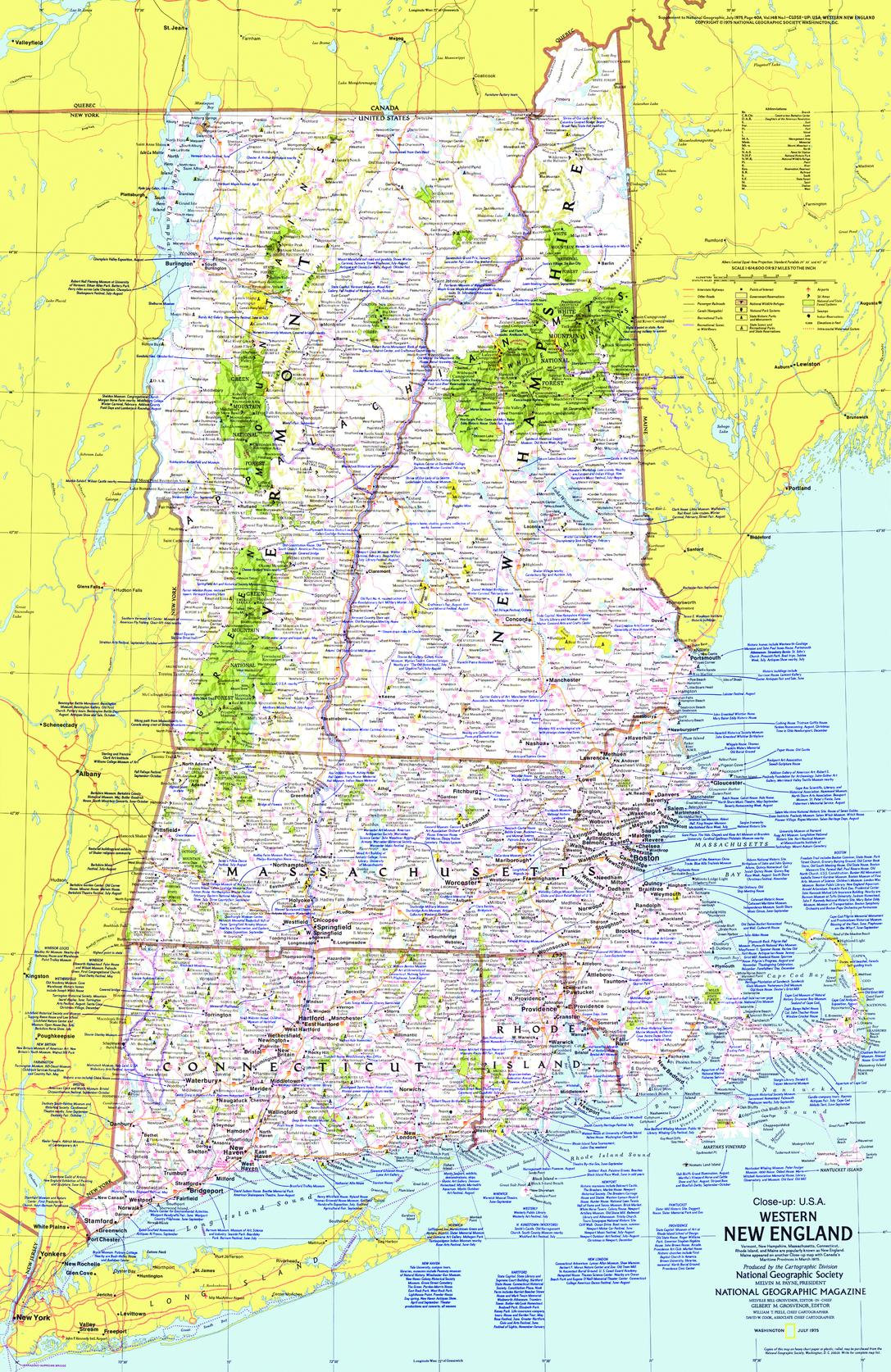
A finely detailed regional map capturing the character and heritage of New England’s western and inland regions. Published by National Geographic in July 1975, this Close-up: U.S.A. edition explores a landscape shaped by mountains, coastlines, historic towns, and enduring cultural traditions.
Covering the broader New England area—including New Hampshire, Vermont, Massachusetts, Rhode Island, and Connecticut—this map offers a richly layered view of a region where history is deeply embedded in the land.
Why This Map Stands Out
A region steeped in history
Highlights one of America’s oldest settled regions—rich in heritage, architecture, and tradition.
Classic National Geographic cartography
Clean typography, balanced colour, and precise detail ensure clarity and visual appeal.
A snapshot of 1970s New England
Captures towns, transport routes, and regional connections of the era.
Part of the Close-up U.S.A. series
A collectible piece from one of National Geographic’s most respected regional map collections.
Rich travel and cultural context
Includes extensive notes on attractions, landscapes, and historic sites.
🗺️ What the Map Shows
- Coverage of Western New England and surrounding states, including New Hampshire, Vermont, Massachusetts, Rhode Island, and Connecticut
- Major towns, cities, and regional transport routes
- Mountain regions such as the Green Mountains and White Mountains
- Coastal features along the New England seaboard, including connections to Cape Cod
- Locations of historic sites, cultural landmarks, and tourist attractions
- A geographic framework linking mountains, forests, coastline, and historic settlements
📐 Size & Format
575 mm (W) × 886 mm (H)
Portrait orientation
A tall, elegant format ideal for:
- Home offices and studies
- Classrooms and history displays
- Libraries and research environments
- Interiors inspired by heritage and coastal New England
✨ Premium Finishes
| Format | Description |
|---|---|
| 📜 Paper (160 gsm) | Heavyweight matte-coated paper—ideal for framing. Preserves crisp detail and vintage tones. |
| 🧼 Laminated (Encapsulated) | Sealed in 2 × 80-micron gloss laminate. Durable, wipe-clean, and suitable for frequent use. |
| 🪵 Laminated + Timber Hang Rails | Laminated map mounted with lacquered natural timber rails and hanging cord—ready to display. |
| 🖼️ Canvas (395 gsm HP Professional Matte) | Printed with archival pigment inks. Rich texture enhances the classic cartographic style. |
| 🪵 Canvas + Timber Hang Rails | Canvas paired with timber rails for a refined, gallery-style presentation. |
🔨 Please allow up to 10 working days for professionally mounted hang-railed finishes.
📊 Specifications
| Feature | Detail |
|---|---|
| Title | Close-up U.S.A. — Western New England |
| Publisher | National Geographic |
| Published | 1975 |
| Scale | 1:614,600 |
| Dimensions | 575 mm × 886 mm |
| Orientation | Portrait |
| Map Type | Regional / Historical |
| Series | Close-up: U.S.A. |
| Coverage | Western New England (NH, VT, MA, RI, CT) |
| Materials | 160 gsm matte paper / 2 × 80-micron laminate / 395 gsm HP Professional Matte Canvas |
| Printing | Pigment-based, fade-resistant inks |
| Origin | Printed in Australia |
🎯 Ideal For
- Collectors of National Geographic and historical maps
- Enthusiasts of New England geography and heritage
- Educators teaching regional U.S. history and landscapes
- Interiors inspired by coastal, rural, or heritage themes
- Gift buyers seeking a meaningful and location-specific map
🍁 A Living Legacy of Place
New England is a region where past and present coexist:
- Mountain landscapes shaped by seasons and tradition
- Coastal towns connected to maritime history
- Villages and cities reflecting centuries of settlement
- A strong cultural identity rooted in land and community
This map captures that essence—revealing a region where history is part of the everyday landscape.
🤝 Our Commitment
- Printed in Australia using archival-quality production
- Faithfully reproduced to preserve original colour and detail
- Premium materials selected for durability and longevity
- Each map is hand-checked before dispatch
- Carefully packaged for safe delivery
🚚 Delivery
- Paper, Laminated, Canvas (rolled): Dispatch within 1–2 business days
- Hang-Railed Maps: Made to order—allow up to 10 working days
- Packaging: Securely rolled in protective tubing
Explore the heritage and landscapes of New England—
a map that captures both place and legacy.
👉 Order now and own a classic piece of National Geographic cartography.
Original: $57.20
-65%$57.20
$20.02Product Information
Product Information
Shipping & Returns
Shipping & Returns
Description
Historic Regional Map | Mountains, Seacoast & Heritage Landscapes | Large Wall Format (575 × 886 mm) | Premium Finishes
A finely detailed regional map capturing the character and heritage of New England’s western and inland regions. Published by National Geographic in July 1975, this Close-up: U.S.A. edition explores a landscape shaped by mountains, coastlines, historic towns, and enduring cultural traditions.
Covering the broader New England area—including New Hampshire, Vermont, Massachusetts, Rhode Island, and Connecticut—this map offers a richly layered view of a region where history is deeply embedded in the land.
Why This Map Stands Out
A region steeped in history
Highlights one of America’s oldest settled regions—rich in heritage, architecture, and tradition.
Classic National Geographic cartography
Clean typography, balanced colour, and precise detail ensure clarity and visual appeal.
A snapshot of 1970s New England
Captures towns, transport routes, and regional connections of the era.
Part of the Close-up U.S.A. series
A collectible piece from one of National Geographic’s most respected regional map collections.
Rich travel and cultural context
Includes extensive notes on attractions, landscapes, and historic sites.
🗺️ What the Map Shows
- Coverage of Western New England and surrounding states, including New Hampshire, Vermont, Massachusetts, Rhode Island, and Connecticut
- Major towns, cities, and regional transport routes
- Mountain regions such as the Green Mountains and White Mountains
- Coastal features along the New England seaboard, including connections to Cape Cod
- Locations of historic sites, cultural landmarks, and tourist attractions
- A geographic framework linking mountains, forests, coastline, and historic settlements
📐 Size & Format
575 mm (W) × 886 mm (H)
Portrait orientation
A tall, elegant format ideal for:
- Home offices and studies
- Classrooms and history displays
- Libraries and research environments
- Interiors inspired by heritage and coastal New England
✨ Premium Finishes
| Format | Description |
|---|---|
| 📜 Paper (160 gsm) | Heavyweight matte-coated paper—ideal for framing. Preserves crisp detail and vintage tones. |
| 🧼 Laminated (Encapsulated) | Sealed in 2 × 80-micron gloss laminate. Durable, wipe-clean, and suitable for frequent use. |
| 🪵 Laminated + Timber Hang Rails | Laminated map mounted with lacquered natural timber rails and hanging cord—ready to display. |
| 🖼️ Canvas (395 gsm HP Professional Matte) | Printed with archival pigment inks. Rich texture enhances the classic cartographic style. |
| 🪵 Canvas + Timber Hang Rails | Canvas paired with timber rails for a refined, gallery-style presentation. |
🔨 Please allow up to 10 working days for professionally mounted hang-railed finishes.
📊 Specifications
| Feature | Detail |
|---|---|
| Title | Close-up U.S.A. — Western New England |
| Publisher | National Geographic |
| Published | 1975 |
| Scale | 1:614,600 |
| Dimensions | 575 mm × 886 mm |
| Orientation | Portrait |
| Map Type | Regional / Historical |
| Series | Close-up: U.S.A. |
| Coverage | Western New England (NH, VT, MA, RI, CT) |
| Materials | 160 gsm matte paper / 2 × 80-micron laminate / 395 gsm HP Professional Matte Canvas |
| Printing | Pigment-based, fade-resistant inks |
| Origin | Printed in Australia |
🎯 Ideal For
- Collectors of National Geographic and historical maps
- Enthusiasts of New England geography and heritage
- Educators teaching regional U.S. history and landscapes
- Interiors inspired by coastal, rural, or heritage themes
- Gift buyers seeking a meaningful and location-specific map
🍁 A Living Legacy of Place
New England is a region where past and present coexist:
- Mountain landscapes shaped by seasons and tradition
- Coastal towns connected to maritime history
- Villages and cities reflecting centuries of settlement
- A strong cultural identity rooted in land and community
This map captures that essence—revealing a region where history is part of the everyday landscape.
🤝 Our Commitment
- Printed in Australia using archival-quality production
- Faithfully reproduced to preserve original colour and detail
- Premium materials selected for durability and longevity
- Each map is hand-checked before dispatch
- Carefully packaged for safe delivery
🚚 Delivery
- Paper, Laminated, Canvas (rolled): Dispatch within 1–2 business days
- Hang-Railed Maps: Made to order—allow up to 10 working days
- Packaging: Securely rolled in protective tubing
Explore the heritage and landscapes of New England—
a map that captures both place and legacy.
👉 Order now and own a classic piece of National Geographic cartography.


