Close-up USA, Wisconsin, Michigan, and the Great Lakes - Published 1973 by National Geographic
Close-up USA, Wisconsin, Michigan, and the Great Lakes - Published 1973 by National Geographic
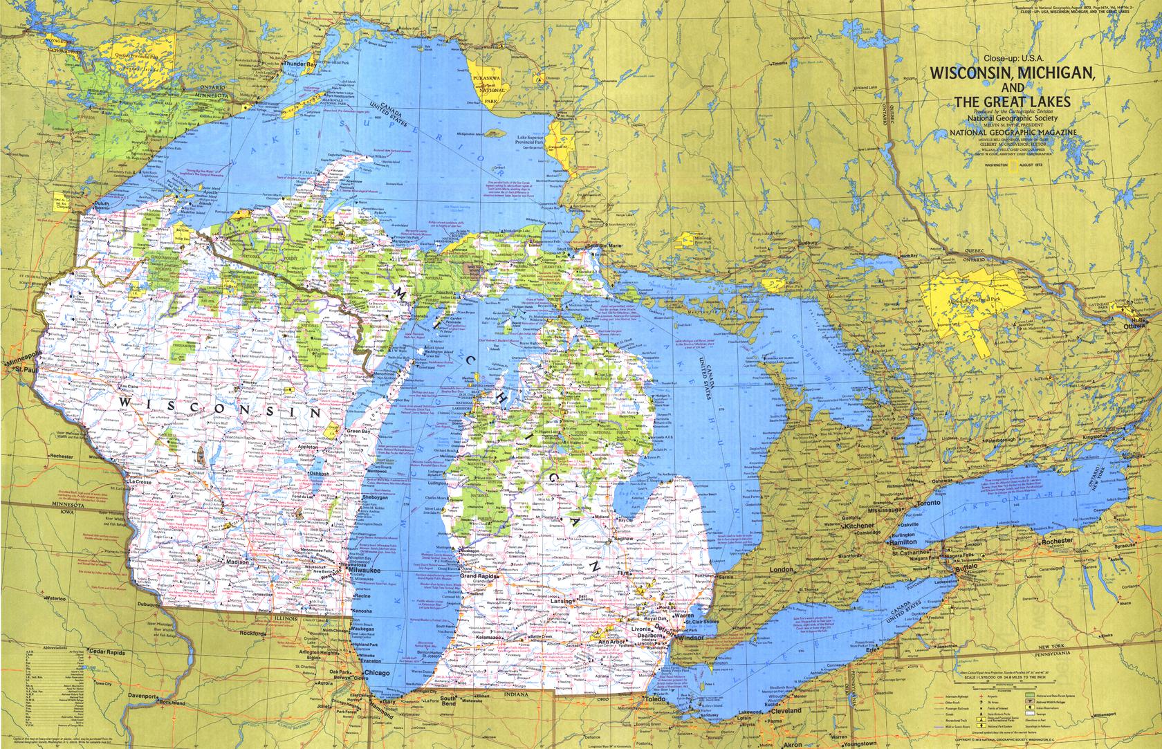
Historic Regional Map | Inland Seas & Northern Landscapes | Large Wall Format (889 × 573 mm) | Premium Finishes
A beautifully detailed regional map capturing the character and natural beauty of the western Great Lakes region. Published by National Geographic in 1973, this Close-up: U.S.A. edition focuses on Wisconsin and Michigan, revealing a landscape defined by vast freshwater coastlines, forests, and lakes.
Centred on the American side of the Great Lakes, this map offers a compelling snapshot of a region where water shapes life, travel, and identity—from shoreline communities to inland wilderness.
Why This Map Stands Out
A region shaped by water
Highlights the Great Lakes as defining geographic features—linking landscapes, economies, and communities.
Classic National Geographic cartography
Clean typography, balanced colour, and precise detail ensure clarity and visual appeal.
A snapshot of 1970s America
Captures transport routes, towns, and regional connections of the era.
Part of the Close-up U.S.A. series
A collectible piece from one of National Geographic’s most respected regional map collections.
Strong travel and visual appeal
Perfect as both a planning reference and a decorative wall map.
🗺️ What the Map Shows
- Detailed coverage of Wisconsin and Michigan, including both the Upper and Lower Peninsulas
- The western Great Lakes system, including Lakes Michigan and Superior
- Major cities, towns, and transport routes across the region
- Coastal features, inland lakes, forests, and recreational areas
- Key vacation destinations and points of interest
- A geographic framework showing the relationship between land, water, and settlement
📐 Size & Format
889 mm (W) × 573 mm (H)
Landscape orientation
A versatile wall size offering strong readability—ideal for:
- Home offices and studies
- Classrooms and geography displays
- Libraries and research environments
- Coastal or lake-inspired interiors
✨ Premium Finishes
| Format | Description |
|---|---|
| 📜 Paper (160 gsm) | Heavyweight matte-coated paper—ideal for framing. Preserves crisp detail and vintage tones. |
| 🧼 Laminated (Encapsulated) | Sealed in 2 × 80-micron gloss laminate. Durable, wipe-clean, and suitable for frequent use. |
| 🪵 Laminated + Timber Hang Rails | Laminated map mounted with lacquered natural timber rails and hanging cord—ready to display. |
| 🖼️ Canvas (395 gsm HP Professional Matte) | Printed with archival pigment inks. Rich texture enhances the classic cartographic style. |
| 🪵 Canvas + Timber Hang Rails | Canvas paired with timber rails for a refined, gallery-style presentation. |
🔨 Please allow up to 10 working days for professionally mounted hang-railed finishes.
📊 Specifications
| Feature | Detail |
|---|---|
| Title | Close-up U.S.A. — Wisconsin, Michigan & the Great Lakes |
| Publisher | National Geographic |
| Published | 1973 |
| Scale | 1:1,570,000 |
| Dimensions | 889 mm × 573 mm |
| Orientation | Landscape |
| Map Type | Regional / Historical |
| Series | Close-up: U.S.A. |
| Coverage | Wisconsin, Michigan, Western Great Lakes |
| Materials | 160 gsm matte paper / 2 × 80-micron laminate / 395 gsm HP Professional Matte Canvas |
| Printing | Pigment-based, fade-resistant inks |
| Origin | Printed in Australia |
🎯 Ideal For
- Collectors of National Geographic and historical maps
- Enthusiasts of Great Lakes geography and regional travel
- Educators teaching U.S. physical geography and water systems
- Interiors inspired by coastal, lake, or northern landscapes
- Gift buyers seeking a distinctive and meaningful regional map
🌊 Land Between the Waters
This region is defined by its unique geography:
- Vast freshwater lakes shaping climate and settlement
- Forested landscapes rich in wildlife and recreation
- Shoreline communities connected by water routes
- A balance between wilderness and human activity
It’s a place where water is not just a feature—but the defining force of the landscape.
🤝 Our Commitment
- Printed in Australia using archival-quality production
- Faithfully reproduced to preserve original colour and detail
- Premium materials selected for durability and longevity
- Each map is hand-checked before dispatch
- Carefully packaged for safe delivery
🚚 Delivery
- Paper, Laminated, Canvas (rolled): Dispatch within 1–2 business days
- Hang-Railed Maps: Made to order—allow up to 10 working days
- Packaging: Securely rolled in protective tubing
Explore the landscapes shaped by the Great Lakes—
a map that captures both water and land in balance.
👉 Order now and own a classic piece of National Geographic cartography.
Product Information
Product Information
Shipping & Returns
Shipping & Returns
Description
Historic Regional Map | Inland Seas & Northern Landscapes | Large Wall Format (889 × 573 mm) | Premium Finishes
A beautifully detailed regional map capturing the character and natural beauty of the western Great Lakes region. Published by National Geographic in 1973, this Close-up: U.S.A. edition focuses on Wisconsin and Michigan, revealing a landscape defined by vast freshwater coastlines, forests, and lakes.
Centred on the American side of the Great Lakes, this map offers a compelling snapshot of a region where water shapes life, travel, and identity—from shoreline communities to inland wilderness.
Why This Map Stands Out
A region shaped by water
Highlights the Great Lakes as defining geographic features—linking landscapes, economies, and communities.
Classic National Geographic cartography
Clean typography, balanced colour, and precise detail ensure clarity and visual appeal.
A snapshot of 1970s America
Captures transport routes, towns, and regional connections of the era.
Part of the Close-up U.S.A. series
A collectible piece from one of National Geographic’s most respected regional map collections.
Strong travel and visual appeal
Perfect as both a planning reference and a decorative wall map.
🗺️ What the Map Shows
- Detailed coverage of Wisconsin and Michigan, including both the Upper and Lower Peninsulas
- The western Great Lakes system, including Lakes Michigan and Superior
- Major cities, towns, and transport routes across the region
- Coastal features, inland lakes, forests, and recreational areas
- Key vacation destinations and points of interest
- A geographic framework showing the relationship between land, water, and settlement
📐 Size & Format
889 mm (W) × 573 mm (H)
Landscape orientation
A versatile wall size offering strong readability—ideal for:
- Home offices and studies
- Classrooms and geography displays
- Libraries and research environments
- Coastal or lake-inspired interiors
✨ Premium Finishes
| Format | Description |
|---|---|
| 📜 Paper (160 gsm) | Heavyweight matte-coated paper—ideal for framing. Preserves crisp detail and vintage tones. |
| 🧼 Laminated (Encapsulated) | Sealed in 2 × 80-micron gloss laminate. Durable, wipe-clean, and suitable for frequent use. |
| 🪵 Laminated + Timber Hang Rails | Laminated map mounted with lacquered natural timber rails and hanging cord—ready to display. |
| 🖼️ Canvas (395 gsm HP Professional Matte) | Printed with archival pigment inks. Rich texture enhances the classic cartographic style. |
| 🪵 Canvas + Timber Hang Rails | Canvas paired with timber rails for a refined, gallery-style presentation. |
🔨 Please allow up to 10 working days for professionally mounted hang-railed finishes.
📊 Specifications
| Feature | Detail |
|---|---|
| Title | Close-up U.S.A. — Wisconsin, Michigan & the Great Lakes |
| Publisher | National Geographic |
| Published | 1973 |
| Scale | 1:1,570,000 |
| Dimensions | 889 mm × 573 mm |
| Orientation | Landscape |
| Map Type | Regional / Historical |
| Series | Close-up: U.S.A. |
| Coverage | Wisconsin, Michigan, Western Great Lakes |
| Materials | 160 gsm matte paper / 2 × 80-micron laminate / 395 gsm HP Professional Matte Canvas |
| Printing | Pigment-based, fade-resistant inks |
| Origin | Printed in Australia |
🎯 Ideal For
- Collectors of National Geographic and historical maps
- Enthusiasts of Great Lakes geography and regional travel
- Educators teaching U.S. physical geography and water systems
- Interiors inspired by coastal, lake, or northern landscapes
- Gift buyers seeking a distinctive and meaningful regional map
🌊 Land Between the Waters
This region is defined by its unique geography:
- Vast freshwater lakes shaping climate and settlement
- Forested landscapes rich in wildlife and recreation
- Shoreline communities connected by water routes
- A balance between wilderness and human activity
It’s a place where water is not just a feature—but the defining force of the landscape.
🤝 Our Commitment
- Printed in Australia using archival-quality production
- Faithfully reproduced to preserve original colour and detail
- Premium materials selected for durability and longevity
- Each map is hand-checked before dispatch
- Carefully packaged for safe delivery
🚚 Delivery
- Paper, Laminated, Canvas (rolled): Dispatch within 1–2 business days
- Hang-Railed Maps: Made to order—allow up to 10 working days
- Packaging: Securely rolled in protective tubing
Explore the landscapes shaped by the Great Lakes—
a map that captures both water and land in balance.
👉 Order now and own a classic piece of National Geographic cartography.


