Colorado Wall Map by National Geographic
Detailed State Reference | Physical Relief, Roads & Recreation | Large Wall Format (1029 × 768 mm) | Premium Finishes
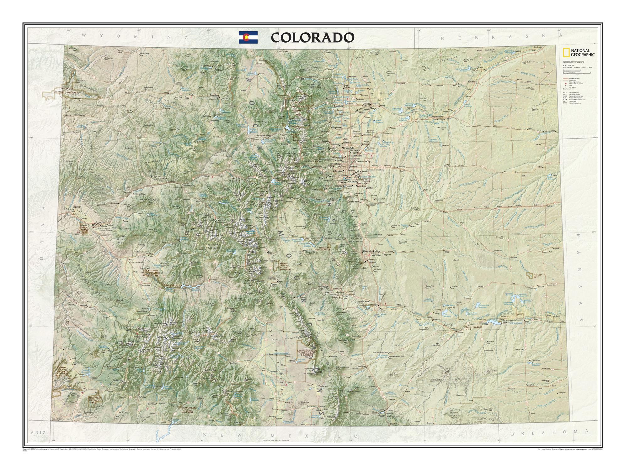
A bold and beautifully detailed portrait of the Centennial State, this Colorado wall map from National Geographic brings the state’s extraordinary terrain into sharp focus. From the high spine of the Rockies to broad plains, plateaus, rivers, and reservoirs, it presents Colorado with the clarity, balance, and authority that define National Geographic cartography.
Part of National Geographic’s acclaimed State Wall Maps series, this edition combines physical richness with practical reference detail. Mountain ranges, prominent summits, lakes, road networks, railways, protected lands, and recreation features are all carefully placed—making this map as useful for planning and study as it is striking on the wall.
This is a map for people who want to see Colorado properly: as landscape, as network, and as destination.
Why This Map Stands Out
A true state-wide overview
Captures Colorado in one clear, comprehensive view—ideal for understanding how mountains, plains, cities, and protected lands fit together.
National Geographic clarity
Combines strong visual design with precise cartographic detail, making it both attractive and highly usable.
Physical landscape rendered beautifully
Mountain ranges, peaks, rivers, lakes, and reservoirs are shown in remarkable detail, revealing the structure of the state.
Built for reference and recreation
Roads, railways, parks, ski areas, and major trails are all included—making this more than a decorative map.
A strong wall presence
At over a metre wide, it has the scale to work beautifully in studies, offices, classrooms, and mountain homes.
🗺️ What the Map Shows
- The full state of Colorado in detailed physical and reference mapping
- Major mountain systems, prominent peaks, high country terrain, and plains
- Lakes, rivers, reservoirs, and other key hydrological features
- Cities, towns, and hundreds of place names across the state
- Major roadways, railways, and airports
- Military installations and other important infrastructure
- Federal and state parks, protected lands, and recreation areas
- Notable outdoor features including the Colorado Trail, Continental Divide Trail, and ski areas
📐 Size & Format
1029 mm (W) × 768 mm (H)
Landscape orientation
A substantial wall format that offers excellent readability and visual presence—ideal for:
- Studies and home offices
- Classrooms and geography rooms
- Lodges, cabins, and mountain homes
- Planning spaces, tourism offices, and boardrooms
✨ Premium Finishes
| Format | Description |
|---|---|
| 📜 Paper (160 gsm) | Heavyweight matte-coated paper—ideal for framing. Crisp detail with a clean, low-glare finish. |
| 🧼 Laminated (Encapsulated) | Sealed in 2 × 80-micron gloss laminate. Durable, wipe-clean, and ideal for repeated reference or annotation. |
| 🪵 Laminated + Timber Hang Rails | Laminated map mounted with lacquered natural timber rails and hanging cord—ready to display. |
| 🖼️ Canvas (395 gsm HP Professional Matte) | Printed with archival pigment inks. Rich texture, reduced glare, and gallery-quality presentation. |
| 🪵 Canvas + Timber Hang Rails | Canvas paired with timber rails for a refined, frame-free display solution. |
🔨 Please allow up to 10 working days for professionally mounted hang-railed finishes.
📊 Specifications
| Feature | Detail |
|---|---|
| Title | Colorado — National Geographic Wall Map |
| Publisher | National Geographic |
| Published | 2021 |
| Scale | 1:705,686 |
| Dimensions | 1029 mm × 768 mm |
| Orientation | Landscape |
| Map Type | Physical / Reference |
| Features | Terrain, peaks, roads, railways, airports, parks, trails, ski areas, reservoirs |
| Materials | 160 gsm matte paper / 2 × 80-micron laminate / 395 gsm HP Professional Matte Canvas |
| Printing | Pigment-based, fade-resistant inks |
| Origin | Printed in Australia |
🎯 Ideal For
- Colorado residents wanting a beautiful, large-format state reference
- Outdoor enthusiasts interested in trails, parks, ski areas, and mountain geography
- Educators and students studying state geography and landforms
- Offices, lodges, and interiors seeking a strong regional focal point
- Gift buyers looking for a thoughtful and practical Colorado map
🏔️ A State Defined by Elevation and Movement
Colorado’s identity is written into its landscape:
- Mountain chains shaping climate, travel, and recreation
- River systems and reservoirs supporting communities and agriculture
- Plains and high plateaus balancing the dramatic western relief
- Protected lands preserving some of the most celebrated scenery in the United States
This map makes those relationships visible. It shows Colorado not simply as a political boundary, but as a living terrain of routes, watersheds, peaks, and destinations.
🤝 Our Commitment
- Printed in Australia using archival-quality production
- Faithfully reproduced for strong colour, clarity, and long-term durability
- Premium materials selected for both display and practical use
- Each map is hand-checked before dispatch
- Carefully packed to arrive in excellent condition
🚚 Delivery
- Paper, Laminated, Canvas (rolled): Dispatch within 1–2 business days
- Hang-Railed Maps: Made to order—allow up to 10 working days
- Packaging: Securely rolled in protective tubing
Bring Colorado’s peaks, trails, parks, and vast geography into clear focus—
a map that is both beautiful on the wall and genuinely useful every day.
👉 Order now and experience Colorado at full scale.
Product Information
Product Information
Shipping & Returns
Shipping & Returns
Description
Detailed State Reference | Physical Relief, Roads & Recreation | Large Wall Format (1029 × 768 mm) | Premium Finishes
A bold and beautifully detailed portrait of the Centennial State, this Colorado wall map from National Geographic brings the state’s extraordinary terrain into sharp focus. From the high spine of the Rockies to broad plains, plateaus, rivers, and reservoirs, it presents Colorado with the clarity, balance, and authority that define National Geographic cartography.
Part of National Geographic’s acclaimed State Wall Maps series, this edition combines physical richness with practical reference detail. Mountain ranges, prominent summits, lakes, road networks, railways, protected lands, and recreation features are all carefully placed—making this map as useful for planning and study as it is striking on the wall.
This is a map for people who want to see Colorado properly: as landscape, as network, and as destination.
Why This Map Stands Out
A true state-wide overview
Captures Colorado in one clear, comprehensive view—ideal for understanding how mountains, plains, cities, and protected lands fit together.
National Geographic clarity
Combines strong visual design with precise cartographic detail, making it both attractive and highly usable.
Physical landscape rendered beautifully
Mountain ranges, peaks, rivers, lakes, and reservoirs are shown in remarkable detail, revealing the structure of the state.
Built for reference and recreation
Roads, railways, parks, ski areas, and major trails are all included—making this more than a decorative map.
A strong wall presence
At over a metre wide, it has the scale to work beautifully in studies, offices, classrooms, and mountain homes.
🗺️ What the Map Shows
- The full state of Colorado in detailed physical and reference mapping
- Major mountain systems, prominent peaks, high country terrain, and plains
- Lakes, rivers, reservoirs, and other key hydrological features
- Cities, towns, and hundreds of place names across the state
- Major roadways, railways, and airports
- Military installations and other important infrastructure
- Federal and state parks, protected lands, and recreation areas
- Notable outdoor features including the Colorado Trail, Continental Divide Trail, and ski areas
📐 Size & Format
1029 mm (W) × 768 mm (H)
Landscape orientation
A substantial wall format that offers excellent readability and visual presence—ideal for:
- Studies and home offices
- Classrooms and geography rooms
- Lodges, cabins, and mountain homes
- Planning spaces, tourism offices, and boardrooms
✨ Premium Finishes
| Format | Description |
|---|---|
| 📜 Paper (160 gsm) | Heavyweight matte-coated paper—ideal for framing. Crisp detail with a clean, low-glare finish. |
| 🧼 Laminated (Encapsulated) | Sealed in 2 × 80-micron gloss laminate. Durable, wipe-clean, and ideal for repeated reference or annotation. |
| 🪵 Laminated + Timber Hang Rails | Laminated map mounted with lacquered natural timber rails and hanging cord—ready to display. |
| 🖼️ Canvas (395 gsm HP Professional Matte) | Printed with archival pigment inks. Rich texture, reduced glare, and gallery-quality presentation. |
| 🪵 Canvas + Timber Hang Rails | Canvas paired with timber rails for a refined, frame-free display solution. |
🔨 Please allow up to 10 working days for professionally mounted hang-railed finishes.
📊 Specifications
| Feature | Detail |
|---|---|
| Title | Colorado — National Geographic Wall Map |
| Publisher | National Geographic |
| Published | 2021 |
| Scale | 1:705,686 |
| Dimensions | 1029 mm × 768 mm |
| Orientation | Landscape |
| Map Type | Physical / Reference |
| Features | Terrain, peaks, roads, railways, airports, parks, trails, ski areas, reservoirs |
| Materials | 160 gsm matte paper / 2 × 80-micron laminate / 395 gsm HP Professional Matte Canvas |
| Printing | Pigment-based, fade-resistant inks |
| Origin | Printed in Australia |
🎯 Ideal For
- Colorado residents wanting a beautiful, large-format state reference
- Outdoor enthusiasts interested in trails, parks, ski areas, and mountain geography
- Educators and students studying state geography and landforms
- Offices, lodges, and interiors seeking a strong regional focal point
- Gift buyers looking for a thoughtful and practical Colorado map
🏔️ A State Defined by Elevation and Movement
Colorado’s identity is written into its landscape:
- Mountain chains shaping climate, travel, and recreation
- River systems and reservoirs supporting communities and agriculture
- Plains and high plateaus balancing the dramatic western relief
- Protected lands preserving some of the most celebrated scenery in the United States
This map makes those relationships visible. It shows Colorado not simply as a political boundary, but as a living terrain of routes, watersheds, peaks, and destinations.
🤝 Our Commitment
- Printed in Australia using archival-quality production
- Faithfully reproduced for strong colour, clarity, and long-term durability
- Premium materials selected for both display and practical use
- Each map is hand-checked before dispatch
- Carefully packed to arrive in excellent condition
🚚 Delivery
- Paper, Laminated, Canvas (rolled): Dispatch within 1–2 business days
- Hang-Railed Maps: Made to order—allow up to 10 working days
- Packaging: Securely rolled in protective tubing
Bring Colorado’s peaks, trails, parks, and vast geography into clear focus—
a map that is both beautiful on the wall and genuinely useful every day.
👉 Order now and experience Colorado at full scale.


