Continental Divide Trail by National Geographic
Epic Long-Distance Trail Map | Mexico to Canada | Panoramic Format (1219 × 457 mm) | Premium Finishes
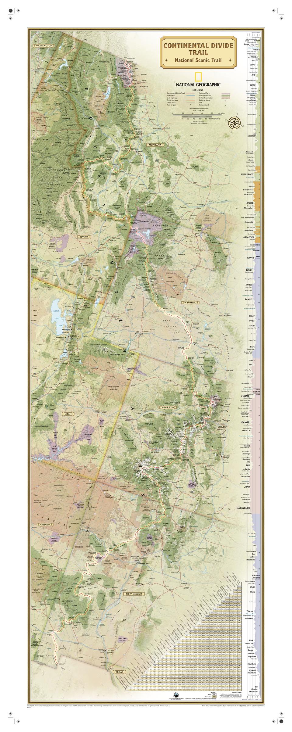
A sweeping, panoramic map of one of the world’s great wilderness journeys. Published by National Geographic, this detailed wall map traces the full length of the Continental Divide Trail—stretching over 3,100 miles from Mexico to Canada along the backbone of the Rocky Mountains.
From desert basins to alpine ridgelines, this map captures the scale, elevation, and challenge of the trail in one continuous view. Whether you’re planning a thru-hike, tracking progress, or simply drawn to the grandeur of the Divide, it offers both practical insight and visual impact.
Why This Map Stands Out
Full trail, end to end
Follows the entire Continental Divide Trail across five states—an uninterrupted view of one of the longest hiking routes in the world.
Built for planning and progress tracking
Ideal for mapping sections, marking milestones, and visualising the full journey.
Elevation profile included
Clearly shows the trail’s peaks, passes, and valleys—essential for understanding terrain and effort.
National Geographic precision
Clean, authoritative cartography ensures readability across vast distances.
Panoramic wall presence
At over 1.2 metres wide, it’s both a functional tool and a dramatic display piece.
🗺️ What the Map Shows
- The full route of the Continental Divide Trail from Mexico to Canada
- Coverage across New Mexico, Colorado, Wyoming, Idaho, and Montana
- A detailed elevation profile highlighting major climbs and descents
- A mileage chart showing distances between key locations
- Major passes, peaks, and watershed divides along the route
- National forests, national parks, and protected wilderness areas
- State parks and Indigenous lands along the trail corridor
- Nearby lodges, campgrounds, and access points
📐 Size & Format
1219 mm (W) × 457 mm (H)
Panoramic landscape orientation
A long-format layout ideal for:
- Planning walls and expedition prep spaces
- Home offices and studies
- Outdoor and adventure-themed interiors
- Tracking progress across the full trail
✨ Premium Finishes
| Format | Description |
|---|---|
| 📜 Paper (160 gsm) | Heavyweight matte-coated paper—ideal for framing. Crisp detail with a low-glare finish. |
| 🧼 Laminated (Encapsulated) | Sealed in 2 × 80-micron gloss laminate. Durable, wipe-clean, and perfect for marking routes or progress. |
| 🪵 Laminated + Timber Hang Rails | Laminated map mounted with lacquered natural timber rails and hanging cord—ready to display. |
| 🖼️ Canvas (395 gsm HP Professional Matte) | Printed with archival pigment inks. Rich texture and reduced glare for a premium finish. |
| 🪵 Canvas + Timber Hang Rails | Canvas paired with timber rails for a refined, gallery-style presentation. |
🔨 Please allow up to 10 working days for professionally mounted hang-railed finishes.
📊 Specifications
| Feature | Detail |
|---|---|
| Title | Continental Divide Trail — National Geographic Map |
| Publisher | National Geographic |
| Published | 2017 |
| Scale | 1:1,900,000 |
| Dimensions | 1219 mm × 457 mm |
| Orientation | Panoramic (Landscape) |
| Map Type | Trail / Physical |
| Features | Trail route, elevation profile, mileage chart, parks, peaks, passes, campgrounds |
| Materials | 160 gsm matte paper / 2 × 80-micron laminate / 395 gsm HP Professional Matte Canvas |
| Printing | Pigment-based, fade-resistant inks |
| Origin | Printed in Australia |
🎯 Ideal For
- Thru-hikers and section hikers of the Continental Divide Trail
- Outdoor enthusiasts and long-distance trekking planners
- Educators exploring terrain, watersheds, and trail systems
- Cabins, gear rooms, and adventure-focused interiors
- Gift buyers seeking a meaningful and inspiring map
🏔️ Following the Spine of a Continent
The Continental Divide Trail is a journey of extremes:
- High alpine passes and remote wilderness
- Watersheds that separate the flow of two oceans
- Landscapes ranging from desert to snow-covered peaks
- A route defined by distance, elevation, and endurance
This map captures that journey—transforming thousands of miles into a clear, continuous story of land and movement.
🤝 Our Commitment
- Printed in Australia using archival-quality production
- Colour-managed for clarity across long-format detail
- Premium materials selected for durability and repeated use
- Each map is hand-checked before dispatch
- Carefully packaged to arrive in excellent condition
🚚 Delivery
- Paper, Laminated, Canvas (rolled): Dispatch within 1–2 business days
- Hang-Railed Maps: Made to order—allow up to 10 working days
- Packaging: Securely rolled in protective tubing
Follow the backbone of North America—
a map that lets you plan it, track it, and experience it from end to end.
👉 Order now and bring the Continental Divide Trail to your wall.
Original: $57.20
-65%$57.20
$20.02Product Information
Product Information
Shipping & Returns
Shipping & Returns
Description
Epic Long-Distance Trail Map | Mexico to Canada | Panoramic Format (1219 × 457 mm) | Premium Finishes
A sweeping, panoramic map of one of the world’s great wilderness journeys. Published by National Geographic, this detailed wall map traces the full length of the Continental Divide Trail—stretching over 3,100 miles from Mexico to Canada along the backbone of the Rocky Mountains.
From desert basins to alpine ridgelines, this map captures the scale, elevation, and challenge of the trail in one continuous view. Whether you’re planning a thru-hike, tracking progress, or simply drawn to the grandeur of the Divide, it offers both practical insight and visual impact.
Why This Map Stands Out
Full trail, end to end
Follows the entire Continental Divide Trail across five states—an uninterrupted view of one of the longest hiking routes in the world.
Built for planning and progress tracking
Ideal for mapping sections, marking milestones, and visualising the full journey.
Elevation profile included
Clearly shows the trail’s peaks, passes, and valleys—essential for understanding terrain and effort.
National Geographic precision
Clean, authoritative cartography ensures readability across vast distances.
Panoramic wall presence
At over 1.2 metres wide, it’s both a functional tool and a dramatic display piece.
🗺️ What the Map Shows
- The full route of the Continental Divide Trail from Mexico to Canada
- Coverage across New Mexico, Colorado, Wyoming, Idaho, and Montana
- A detailed elevation profile highlighting major climbs and descents
- A mileage chart showing distances between key locations
- Major passes, peaks, and watershed divides along the route
- National forests, national parks, and protected wilderness areas
- State parks and Indigenous lands along the trail corridor
- Nearby lodges, campgrounds, and access points
📐 Size & Format
1219 mm (W) × 457 mm (H)
Panoramic landscape orientation
A long-format layout ideal for:
- Planning walls and expedition prep spaces
- Home offices and studies
- Outdoor and adventure-themed interiors
- Tracking progress across the full trail
✨ Premium Finishes
| Format | Description |
|---|---|
| 📜 Paper (160 gsm) | Heavyweight matte-coated paper—ideal for framing. Crisp detail with a low-glare finish. |
| 🧼 Laminated (Encapsulated) | Sealed in 2 × 80-micron gloss laminate. Durable, wipe-clean, and perfect for marking routes or progress. |
| 🪵 Laminated + Timber Hang Rails | Laminated map mounted with lacquered natural timber rails and hanging cord—ready to display. |
| 🖼️ Canvas (395 gsm HP Professional Matte) | Printed with archival pigment inks. Rich texture and reduced glare for a premium finish. |
| 🪵 Canvas + Timber Hang Rails | Canvas paired with timber rails for a refined, gallery-style presentation. |
🔨 Please allow up to 10 working days for professionally mounted hang-railed finishes.
📊 Specifications
| Feature | Detail |
|---|---|
| Title | Continental Divide Trail — National Geographic Map |
| Publisher | National Geographic |
| Published | 2017 |
| Scale | 1:1,900,000 |
| Dimensions | 1219 mm × 457 mm |
| Orientation | Panoramic (Landscape) |
| Map Type | Trail / Physical |
| Features | Trail route, elevation profile, mileage chart, parks, peaks, passes, campgrounds |
| Materials | 160 gsm matte paper / 2 × 80-micron laminate / 395 gsm HP Professional Matte Canvas |
| Printing | Pigment-based, fade-resistant inks |
| Origin | Printed in Australia |
🎯 Ideal For
- Thru-hikers and section hikers of the Continental Divide Trail
- Outdoor enthusiasts and long-distance trekking planners
- Educators exploring terrain, watersheds, and trail systems
- Cabins, gear rooms, and adventure-focused interiors
- Gift buyers seeking a meaningful and inspiring map
🏔️ Following the Spine of a Continent
The Continental Divide Trail is a journey of extremes:
- High alpine passes and remote wilderness
- Watersheds that separate the flow of two oceans
- Landscapes ranging from desert to snow-covered peaks
- A route defined by distance, elevation, and endurance
This map captures that journey—transforming thousands of miles into a clear, continuous story of land and movement.
🤝 Our Commitment
- Printed in Australia using archival-quality production
- Colour-managed for clarity across long-format detail
- Premium materials selected for durability and repeated use
- Each map is hand-checked before dispatch
- Carefully packaged to arrive in excellent condition
🚚 Delivery
- Paper, Laminated, Canvas (rolled): Dispatch within 1–2 business days
- Hang-Railed Maps: Made to order—allow up to 10 working days
- Packaging: Securely rolled in protective tubing
Follow the backbone of North America—
a map that lets you plan it, track it, and experience it from end to end.
👉 Order now and bring the Continental Divide Trail to your wall.


