County Map of Ayreshire 900 x 900 mm
Discover the Rugged Coastlines and Rolling Farmland of Historic Ayrshire — Beautifully Mapped for Home, Office, or Classroom
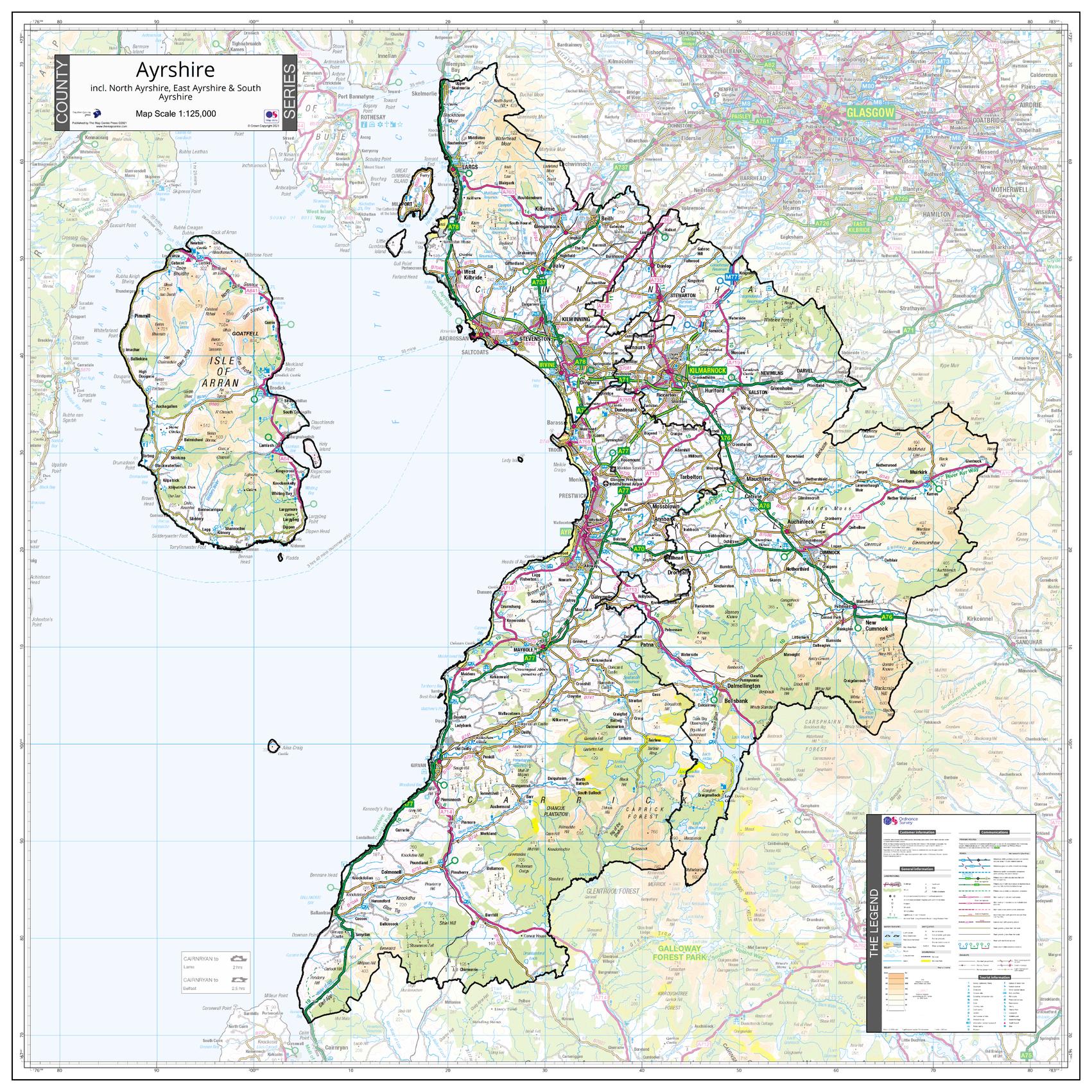
Capture the sweeping charm of Ayrshire with this expertly crafted county wall map, created using detailed Ordnance Survey data. From the elegant seaside town of Ayr to the windswept beauty of the Isle of Arran, this map provides a complete and authoritative view of one of Scotland’s most storied counties.
The map shows the entire county boundary, including applicable Unitary Authority areas, with the surrounding areas gently faded out to maintain a strong visual focus on Ayrshire itself. Part of a visually consistent series covering all counties of England, Scotland, and Wales, this map blends accuracy, design, and regional pride in one timeless display.
🧭 Highlights Include:
| Region | Highlights |
|---|---|
| Ayr | Historic county town with beautiful beaches and golf heritage |
| Isle of Arran | A microcosm of Scottish landscapes — mountains, coastline, castles, and glens |
| Kilmarnock | Birthplace of Johnnie Walker, historic textile industry |
| Irvine & Troon | Bustling harbours, ferry terminals, and sandy shores |
| Girvan & Largs | Gateway to the Firth of Clyde and island adventures |
The map clearly marks major towns, villages, roads, rivers, and natural features, all using trusted OS cartographic standards.
📐 Map Specifications
| Feature | Details |
|---|---|
| Dimensions | 900 mm (wide) x 900 mm (high) |
| Cartography | Ordnance Survey |
| County Coverage | Full Ayrshire incl. Unitary Authorities |
| Surrounding Mapping | Soft fade beyond county boundary |
| Series Consistency | Part of the UK Counties Wall Map Series |
| Latest Edition | 2021 |
🖨️ Available Format Options
| 📄 Format | 📝 Details |
|---|---|
| Paper (160 gsm) | High-quality matte finish — ideal for framing under glass |
| Laminated | Durable and waterproof — fully encapsulated in 80-micron gloss laminate |
| Laminated with Hang Rails | Ready-to-hang format with smooth timber rails and a top cord — stylish and simple |
| Canvas (395 gsm) | Printed on heavyweight HP matte canvas with pigment inks — rich and fade-resistant |
| Canvas with Hang Rails | A bold statement piece — canvas with natural timber hang rails, ready to display |
📦 Please allow up to 10 working days for hang-railed formats due to custom finishing.
🎯 Perfect For:
-
🏢 Council and planning offices
-
🏡 Home decorators with regional ties
-
🎓 Teachers and students studying Scottish geography
-
🎁 Proud locals, history buffs, and travel enthusiasts
-
🧭 Genealogy and ancestry researchers
Bring the rich landscapes, coastal towns, and cultural heritage of Ayrshire into focus with a map that’s as practical as it is beautiful — a perfect blend of precision, pride, and presentation.
Original: $50.05
-65%$50.05
$17.52Product Information
Product Information
Shipping & Returns
Shipping & Returns
Description
Discover the Rugged Coastlines and Rolling Farmland of Historic Ayrshire — Beautifully Mapped for Home, Office, or Classroom
Capture the sweeping charm of Ayrshire with this expertly crafted county wall map, created using detailed Ordnance Survey data. From the elegant seaside town of Ayr to the windswept beauty of the Isle of Arran, this map provides a complete and authoritative view of one of Scotland’s most storied counties.
The map shows the entire county boundary, including applicable Unitary Authority areas, with the surrounding areas gently faded out to maintain a strong visual focus on Ayrshire itself. Part of a visually consistent series covering all counties of England, Scotland, and Wales, this map blends accuracy, design, and regional pride in one timeless display.
🧭 Highlights Include:
| Region | Highlights |
|---|---|
| Ayr | Historic county town with beautiful beaches and golf heritage |
| Isle of Arran | A microcosm of Scottish landscapes — mountains, coastline, castles, and glens |
| Kilmarnock | Birthplace of Johnnie Walker, historic textile industry |
| Irvine & Troon | Bustling harbours, ferry terminals, and sandy shores |
| Girvan & Largs | Gateway to the Firth of Clyde and island adventures |
The map clearly marks major towns, villages, roads, rivers, and natural features, all using trusted OS cartographic standards.
📐 Map Specifications
| Feature | Details |
|---|---|
| Dimensions | 900 mm (wide) x 900 mm (high) |
| Cartography | Ordnance Survey |
| County Coverage | Full Ayrshire incl. Unitary Authorities |
| Surrounding Mapping | Soft fade beyond county boundary |
| Series Consistency | Part of the UK Counties Wall Map Series |
| Latest Edition | 2021 |
🖨️ Available Format Options
| 📄 Format | 📝 Details |
|---|---|
| Paper (160 gsm) | High-quality matte finish — ideal for framing under glass |
| Laminated | Durable and waterproof — fully encapsulated in 80-micron gloss laminate |
| Laminated with Hang Rails | Ready-to-hang format with smooth timber rails and a top cord — stylish and simple |
| Canvas (395 gsm) | Printed on heavyweight HP matte canvas with pigment inks — rich and fade-resistant |
| Canvas with Hang Rails | A bold statement piece — canvas with natural timber hang rails, ready to display |
📦 Please allow up to 10 working days for hang-railed formats due to custom finishing.
🎯 Perfect For:
-
🏢 Council and planning offices
-
🏡 Home decorators with regional ties
-
🎓 Teachers and students studying Scottish geography
-
🎁 Proud locals, history buffs, and travel enthusiasts
-
🧭 Genealogy and ancestry researchers
Bring the rich landscapes, coastal towns, and cultural heritage of Ayrshire into focus with a map that’s as practical as it is beautiful — a perfect blend of precision, pride, and presentation.