County Map of Durham 1160 x 880mm
A Striking Ordnance Survey Wall Map Highlighting County Durham and Its Surrounds
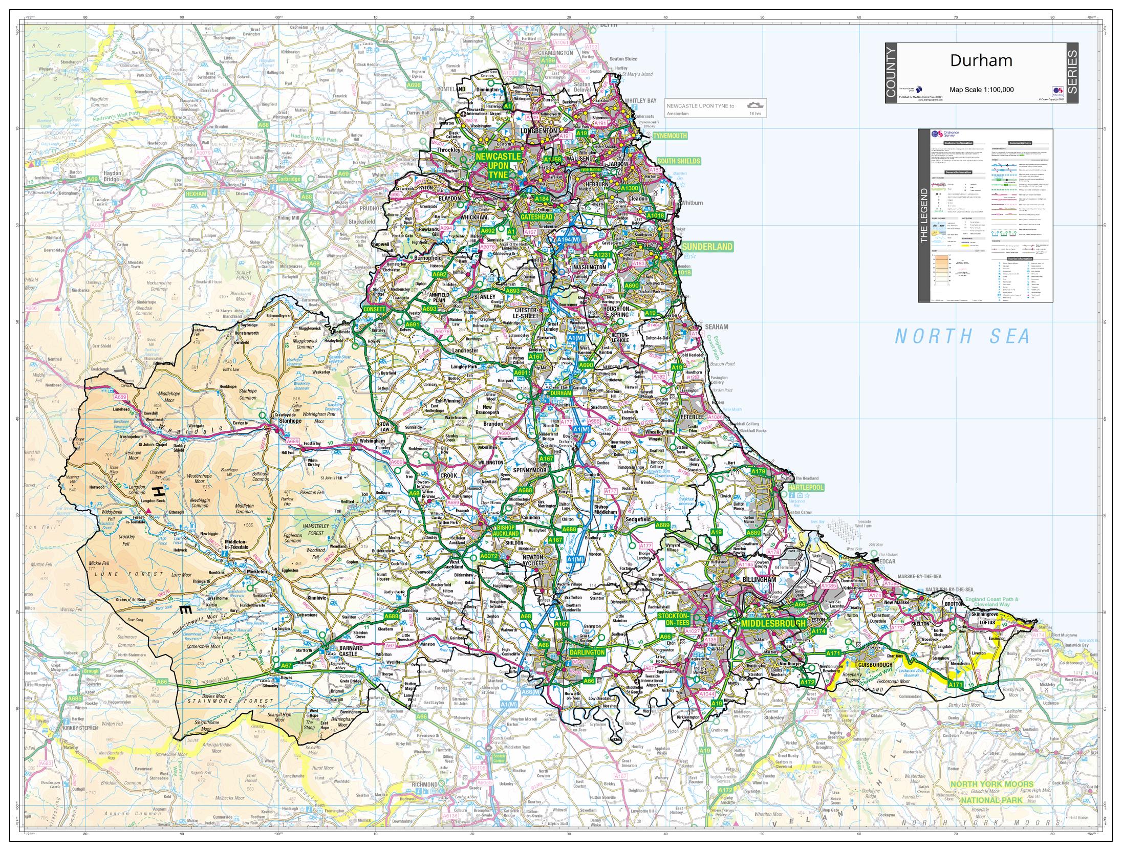
Celebrate the rich heritage and varied landscape of County Durham with this beautifully detailed wall map based on official Ordnance Survey mapping. Whether you're exploring the ancient cathedral city of Durham, the dynamic urban centres of Newcastle upon Tyne and Sunderland, or the rolling countryside of the Durham Dales, this map presents the region with clarity and precision.
Designed to highlight County Durham in full, this map outlines county and Unitary Authority boundaries, with neighbouring areas subtly faded — ensuring the county remains the visual focus. As part of a cohesive UK Counties Map Series, it can be seamlessly paired with other counties for a professional or decorative display.
🗝️ Key Features
-
✅ Complete coverage of County Durham, including key urban centres
-
🗺️ Official Ordnance Survey cartography ensures accuracy and detail
-
🛣️ Shows roads, towns, villages, rivers, railways, parks, and elevation
-
🌐 Clearly marked county and Unitary Authority boundaries
-
🌄 Mapping beyond the county boundary is faded to enhance regional focus
-
🧩 Matches other titles in the England, Scotland & Wales County Series
📍 Includes Prominent Areas Such As:
| Location | Key Features |
|---|---|
| Durham | World Heritage cathedral and university city |
| Newcastle upon Tyne | Historic riverfront, vibrant arts and culture scene |
| Sunderland | Coastal city with maritime heritage and green spaces |
| Bishop Auckland | Auckland Castle, heritage railways, historic market town |
| Durham Dales & Weardale | Countryside, walking trails, and rural villages |
📐 Map Specifications
| Specification | Details |
|---|---|
| Dimensions | 1160 mm (wide) x 880 mm (high) |
| Map Edition | 2021 |
| Source | Ordnance Survey |
| Series | UK County Wall Map Series |
🖨️ Available Format Options
| 📄 Format | 📋 Description |
|---|---|
| Paper | Printed on 160 gsm matte-coated paper — ideal for framing or mounting |
| Laminated | Encapsulated in 80-micron gloss laminate — waterproof, durable, and wipe-clean |
| Laminated with Hang Rails | Fitted with timber rails and hanging cord — ready to display |
| Canvas | Printed on 395 gsm HP Matte Canvas — fade-resistant with vivid, archival-quality inks |
| Canvas with Hang Rails | Supplied with natural timber hangers — premium wall decor with practical appeal |
🛠️ Please allow up to 10 working days for canvas and rail-mounted formats, as each is custom-finished by our in-house framer.
🎯 Ideal For:
-
🏠 Residents and local history enthusiasts in County Durham
-
🏛️ Councils, town planners, and local authorities
-
🎓 Educational institutions and geography classrooms
-
🧭 Tourist centres, B&Bs, and hospitality venues
-
🎁 A thoughtful gift for anyone with ties to the region
Celebrate the diversity of the North East and its historic heartland with this refined County Durham wall map — a timeless and informative addition to homes, schools, and offices alike.
Original: $50.05
-65%$50.05
$17.52Product Information
Product Information
Shipping & Returns
Shipping & Returns
Description
A Striking Ordnance Survey Wall Map Highlighting County Durham and Its Surrounds
Celebrate the rich heritage and varied landscape of County Durham with this beautifully detailed wall map based on official Ordnance Survey mapping. Whether you're exploring the ancient cathedral city of Durham, the dynamic urban centres of Newcastle upon Tyne and Sunderland, or the rolling countryside of the Durham Dales, this map presents the region with clarity and precision.
Designed to highlight County Durham in full, this map outlines county and Unitary Authority boundaries, with neighbouring areas subtly faded — ensuring the county remains the visual focus. As part of a cohesive UK Counties Map Series, it can be seamlessly paired with other counties for a professional or decorative display.
🗝️ Key Features
-
✅ Complete coverage of County Durham, including key urban centres
-
🗺️ Official Ordnance Survey cartography ensures accuracy and detail
-
🛣️ Shows roads, towns, villages, rivers, railways, parks, and elevation
-
🌐 Clearly marked county and Unitary Authority boundaries
-
🌄 Mapping beyond the county boundary is faded to enhance regional focus
-
🧩 Matches other titles in the England, Scotland & Wales County Series
📍 Includes Prominent Areas Such As:
| Location | Key Features |
|---|---|
| Durham | World Heritage cathedral and university city |
| Newcastle upon Tyne | Historic riverfront, vibrant arts and culture scene |
| Sunderland | Coastal city with maritime heritage and green spaces |
| Bishop Auckland | Auckland Castle, heritage railways, historic market town |
| Durham Dales & Weardale | Countryside, walking trails, and rural villages |
📐 Map Specifications
| Specification | Details |
|---|---|
| Dimensions | 1160 mm (wide) x 880 mm (high) |
| Map Edition | 2021 |
| Source | Ordnance Survey |
| Series | UK County Wall Map Series |
🖨️ Available Format Options
| 📄 Format | 📋 Description |
|---|---|
| Paper | Printed on 160 gsm matte-coated paper — ideal for framing or mounting |
| Laminated | Encapsulated in 80-micron gloss laminate — waterproof, durable, and wipe-clean |
| Laminated with Hang Rails | Fitted with timber rails and hanging cord — ready to display |
| Canvas | Printed on 395 gsm HP Matte Canvas — fade-resistant with vivid, archival-quality inks |
| Canvas with Hang Rails | Supplied with natural timber hangers — premium wall decor with practical appeal |
🛠️ Please allow up to 10 working days for canvas and rail-mounted formats, as each is custom-finished by our in-house framer.
🎯 Ideal For:
-
🏠 Residents and local history enthusiasts in County Durham
-
🏛️ Councils, town planners, and local authorities
-
🎓 Educational institutions and geography classrooms
-
🧭 Tourist centres, B&Bs, and hospitality venues
-
🎁 A thoughtful gift for anyone with ties to the region
Celebrate the diversity of the North East and its historic heartland with this refined County Durham wall map — a timeless and informative addition to homes, schools, and offices alike.