County Map of Glamorgan 1200 x 800mm
An Elegant Ordnance Survey Wall Map Highlighting the Historic Heart of South Wales
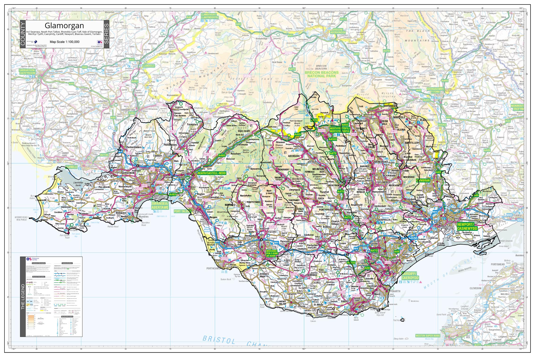
Step into the dynamic landscapes and cultural depth of Glamorgan with this large-format, finely detailed wall map, built on authoritative Ordnance Survey data. From the cosmopolitan waterfront of Cardiff Bay to the rugged coastlines of the Vale of Glamorgan and the industrial roots of Swansea and the Valleys, this map showcases the full breadth of this iconic South Wales county.
Carefully designed for visual clarity, the map distinctly outlines Glamorgan’s county boundaries, including Unitary Authorities such as Cardiff, Swansea, and Newport. To keep focus on the county, the surrounding areas are gently faded, creating a beautiful visual effect ideal for wall display.
Part of a matching series of County Maps covering England, Scotland, and Wales, this piece brings cartographic harmony and regional pride to any setting — be it the classroom, boardroom, or living room.
🧭 Map Highlights
-
✅ Covers the entire historic county of Glamorgan
-
📍 Clearly shows Unitary Authority boundaries for Cardiff, Swansea, and Newport
-
🏞️ Depicts roads, rivers, forests, and settlement patterns in rich detail
-
🌍 Background mapping fades beyond county borders to maintain regional focus
-
🎯 Consistent with all maps in the UK County Series using Ordnance Survey cartography
📍 Key Towns and Features Included
| Location | What You’ll Find |
|---|---|
| Cardiff | Capital of Wales, Cardiff Castle, Principality Stadium |
| Swansea | Swansea Bay, Maritime Quarter, nearby Gower Peninsula |
| Newport | Transporter Bridge, cultural centres, access to the Wye Valley |
| Bridgend | Mid-Glamorgan market town, gateway to the coast and uplands |
| Barry | Heritage coastline, Barry Island, family attractions |
📐 Map Specifications
| Attribute | Details |
|---|---|
| Map Dimensions | 1200 mm (wide) x 800 mm (high) |
| Edition | 2021 |
| Data Source | Ordnance Survey (UK) |
| Map Series | County Map Series – UK Wide Coverage |
🖨️ Format & Finish Options
| 📄 Format | 📋 Details |
|---|---|
| Paper | 160 gsm matte-coated stock – ideal for framing under glass |
| Laminated | 80-micron gloss-laminated (true encapsulation) – waterproof and wipeable |
| Laminated with Hang Rails | Supplied ready-to-hang with natural timber rails and cord |
| Canvas | Printed on 395 gsm HP Matte Canvas – archival pigment inks, vibrant & durable |
| Canvas with Hang Rails | Premium canvas finish with hand-mounted timber rails – stylish and timeless |
⏳ Please allow up to 10 working days for rail-mounted options, as these are made to order by our specialist framer.
🎯 Who Is This Map For?
-
🏡 Proud Glamorganshire residents wanting a striking feature wall piece
-
🗂️ Business offices, council chambers, and planning departments
-
🎓 Geography teachers, students, and history enthusiasts
-
🧭 Travel lovers, heritage collectors, and genealogists
-
🎁 A thoughtful gift for anyone connected to South Wales
Celebrate the landscapes, cities, and rich industrial heritage of Glamorgan with this stunning county map — a meaningful and visually captivating tribute to one of Wales’s most storied regions.
Original: $50.05
-65%$50.05
$17.52Product Information
Product Information
Shipping & Returns
Shipping & Returns
Description
An Elegant Ordnance Survey Wall Map Highlighting the Historic Heart of South Wales
Step into the dynamic landscapes and cultural depth of Glamorgan with this large-format, finely detailed wall map, built on authoritative Ordnance Survey data. From the cosmopolitan waterfront of Cardiff Bay to the rugged coastlines of the Vale of Glamorgan and the industrial roots of Swansea and the Valleys, this map showcases the full breadth of this iconic South Wales county.
Carefully designed for visual clarity, the map distinctly outlines Glamorgan’s county boundaries, including Unitary Authorities such as Cardiff, Swansea, and Newport. To keep focus on the county, the surrounding areas are gently faded, creating a beautiful visual effect ideal for wall display.
Part of a matching series of County Maps covering England, Scotland, and Wales, this piece brings cartographic harmony and regional pride to any setting — be it the classroom, boardroom, or living room.
🧭 Map Highlights
-
✅ Covers the entire historic county of Glamorgan
-
📍 Clearly shows Unitary Authority boundaries for Cardiff, Swansea, and Newport
-
🏞️ Depicts roads, rivers, forests, and settlement patterns in rich detail
-
🌍 Background mapping fades beyond county borders to maintain regional focus
-
🎯 Consistent with all maps in the UK County Series using Ordnance Survey cartography
📍 Key Towns and Features Included
| Location | What You’ll Find |
|---|---|
| Cardiff | Capital of Wales, Cardiff Castle, Principality Stadium |
| Swansea | Swansea Bay, Maritime Quarter, nearby Gower Peninsula |
| Newport | Transporter Bridge, cultural centres, access to the Wye Valley |
| Bridgend | Mid-Glamorgan market town, gateway to the coast and uplands |
| Barry | Heritage coastline, Barry Island, family attractions |
📐 Map Specifications
| Attribute | Details |
|---|---|
| Map Dimensions | 1200 mm (wide) x 800 mm (high) |
| Edition | 2021 |
| Data Source | Ordnance Survey (UK) |
| Map Series | County Map Series – UK Wide Coverage |
🖨️ Format & Finish Options
| 📄 Format | 📋 Details |
|---|---|
| Paper | 160 gsm matte-coated stock – ideal for framing under glass |
| Laminated | 80-micron gloss-laminated (true encapsulation) – waterproof and wipeable |
| Laminated with Hang Rails | Supplied ready-to-hang with natural timber rails and cord |
| Canvas | Printed on 395 gsm HP Matte Canvas – archival pigment inks, vibrant & durable |
| Canvas with Hang Rails | Premium canvas finish with hand-mounted timber rails – stylish and timeless |
⏳ Please allow up to 10 working days for rail-mounted options, as these are made to order by our specialist framer.
🎯 Who Is This Map For?
-
🏡 Proud Glamorganshire residents wanting a striking feature wall piece
-
🗂️ Business offices, council chambers, and planning departments
-
🎓 Geography teachers, students, and history enthusiasts
-
🧭 Travel lovers, heritage collectors, and genealogists
-
🎁 A thoughtful gift for anyone connected to South Wales
Celebrate the landscapes, cities, and rich industrial heritage of Glamorgan with this stunning county map — a meaningful and visually captivating tribute to one of Wales’s most storied regions.