County Map of Norfolk 1060 x 800mm
A Beautifully Detailed Ordnance Survey Wall Map of Norfolk, England’s Iconic East Coast County
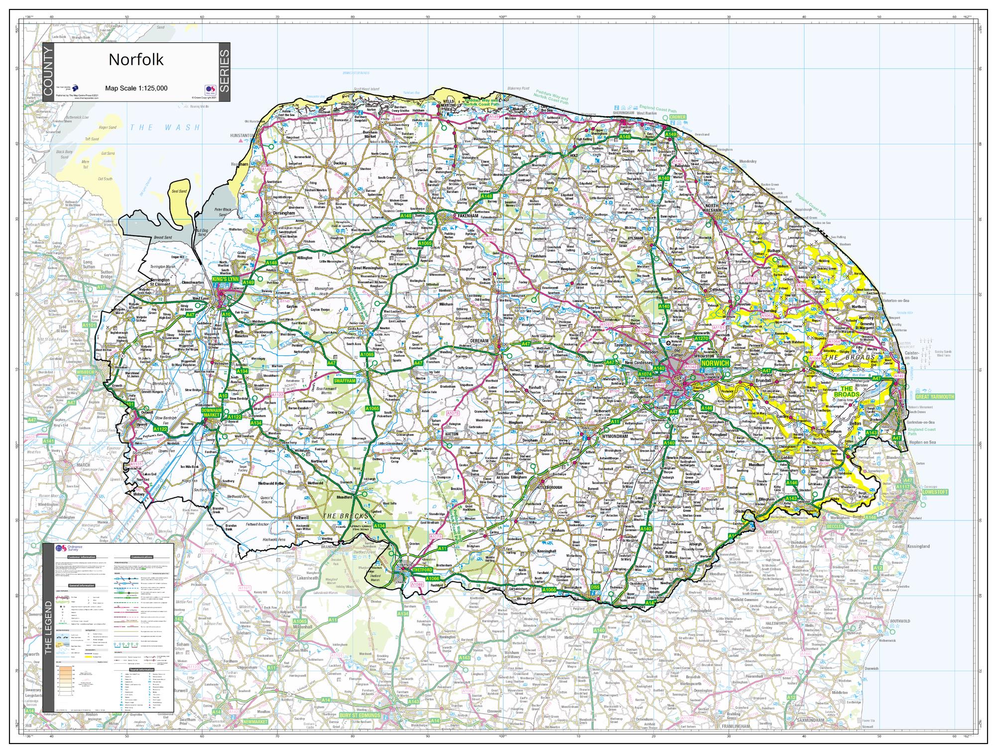
Celebrate the open skies, rich history, and sweeping rural landscapes of Norfolk with this elegant wall map, crafted using official Ordnance Survey data. Capturing the entirety of the county within a defined boundary, the surrounding areas are softly faded to keep Norfolk at the heart of the display. Whether you're planning journeys, teaching geography, or showcasing regional pride, this map provides clarity, precision, and aesthetic appeal.
Part of a cohesive County Map Series spanning England, Scotland, and Wales, this map aligns perfectly with others in the range, offering visual continuity and consistent cartographic quality — ideal for collectors, councils, educators, or business settings.
🌟 Key Features
-
🧭 Full coverage of Norfolk, including all relevant Unitary Authority boundaries
-
🗺️ High-resolution Ordnance Survey base mapping with town names, roads, rivers, and natural features
-
🎨 Surrounding regions faded to ensure Norfolk is clearly defined and centre-stage
-
🧩 Part of a wider UK County Map series using the same design template and scale
-
🏞️ Includes towns, roads, waterways, forests, national parks, and coastline detail
📍 Featured Locations on the Map
| Location | Highlights |
|---|---|
| Norwich | Historic city centre, cathedral, university, and riverside areas |
| Great Yarmouth | Seafront promenade, piers, and gateway to the Broads |
| The Norfolk Broads | Extensive network of rivers, lakes, and nature reserves |
| King’s Lynn | Medieval port town, market square, heritage buildings |
| Cromer & Sheringham | Coastal towns with beaches and access to walking trails |
| Thetford Forest | One of the largest lowland forests in Britain, with walking & cycling trails |
📐 Product Specifications
| Attribute | Details |
|---|---|
| Dimensions | 1060 mm (wide) x 800 mm (high) |
| Data Source | Ordnance Survey |
| Edition | 2021 |
| Map Series | County Series – England, Scotland & Wales |
🖨️ Available Format Options
| 📄 Format | 📝 Description |
|---|---|
| Paper | Printed on 160 gsm matte-coated paper — perfect for framing or display. |
| Laminated | Fully encapsulated in 80-micron gloss laminate — waterproof, tear-resistant, and wipeable. |
| Laminated with Hang Rails | Includes top and bottom timber rails and cord — ready to hang with ease. |
| Canvas | Printed on 395 gsm HP Matte Canvas with pigment inks — fade-resistant and richly textured. |
| Canvas with Hang Rails | Mounted on natural timber hang rails for a classic, display-ready look. |
🛠️ Please allow up to 10 working days for delivery of hang-railed versions, as each is hand-finished by our framing team.
🎯 Ideal For:
-
County councils, planning departments, and public institutions
-
Geography classrooms and history teachers
-
Holiday homes and accommodation providers across Norfolk
-
Proud residents and Norfolk-born collectors
-
Businesses needing a regional planning or display map
Embrace the beauty and structure of Norfolk with this professionally produced wall map — a statement piece that combines cartographic authority with timeless elegance.
📌 Accurate. Inspiring. Made to last.
Original: $50.05
-65%$50.05
$17.52Product Information
Product Information
Shipping & Returns
Shipping & Returns
Description
A Beautifully Detailed Ordnance Survey Wall Map of Norfolk, England’s Iconic East Coast County
Celebrate the open skies, rich history, and sweeping rural landscapes of Norfolk with this elegant wall map, crafted using official Ordnance Survey data. Capturing the entirety of the county within a defined boundary, the surrounding areas are softly faded to keep Norfolk at the heart of the display. Whether you're planning journeys, teaching geography, or showcasing regional pride, this map provides clarity, precision, and aesthetic appeal.
Part of a cohesive County Map Series spanning England, Scotland, and Wales, this map aligns perfectly with others in the range, offering visual continuity and consistent cartographic quality — ideal for collectors, councils, educators, or business settings.
🌟 Key Features
-
🧭 Full coverage of Norfolk, including all relevant Unitary Authority boundaries
-
🗺️ High-resolution Ordnance Survey base mapping with town names, roads, rivers, and natural features
-
🎨 Surrounding regions faded to ensure Norfolk is clearly defined and centre-stage
-
🧩 Part of a wider UK County Map series using the same design template and scale
-
🏞️ Includes towns, roads, waterways, forests, national parks, and coastline detail
📍 Featured Locations on the Map
| Location | Highlights |
|---|---|
| Norwich | Historic city centre, cathedral, university, and riverside areas |
| Great Yarmouth | Seafront promenade, piers, and gateway to the Broads |
| The Norfolk Broads | Extensive network of rivers, lakes, and nature reserves |
| King’s Lynn | Medieval port town, market square, heritage buildings |
| Cromer & Sheringham | Coastal towns with beaches and access to walking trails |
| Thetford Forest | One of the largest lowland forests in Britain, with walking & cycling trails |
📐 Product Specifications
| Attribute | Details |
|---|---|
| Dimensions | 1060 mm (wide) x 800 mm (high) |
| Data Source | Ordnance Survey |
| Edition | 2021 |
| Map Series | County Series – England, Scotland & Wales |
🖨️ Available Format Options
| 📄 Format | 📝 Description |
|---|---|
| Paper | Printed on 160 gsm matte-coated paper — perfect for framing or display. |
| Laminated | Fully encapsulated in 80-micron gloss laminate — waterproof, tear-resistant, and wipeable. |
| Laminated with Hang Rails | Includes top and bottom timber rails and cord — ready to hang with ease. |
| Canvas | Printed on 395 gsm HP Matte Canvas with pigment inks — fade-resistant and richly textured. |
| Canvas with Hang Rails | Mounted on natural timber hang rails for a classic, display-ready look. |
🛠️ Please allow up to 10 working days for delivery of hang-railed versions, as each is hand-finished by our framing team.
🎯 Ideal For:
-
County councils, planning departments, and public institutions
-
Geography classrooms and history teachers
-
Holiday homes and accommodation providers across Norfolk
-
Proud residents and Norfolk-born collectors
-
Businesses needing a regional planning or display map
Embrace the beauty and structure of Norfolk with this professionally produced wall map — a statement piece that combines cartographic authority with timeless elegance.
📌 Accurate. Inspiring. Made to last.